This item has been sold, but you can get on the Waitlist to be notified if another example becomes available, or purchase a digital scan.
1644 Jansson Map of Brazil during Dutch-Portuguese Wars
BrasiliaeTabula-jansson-1644$600.00

Title
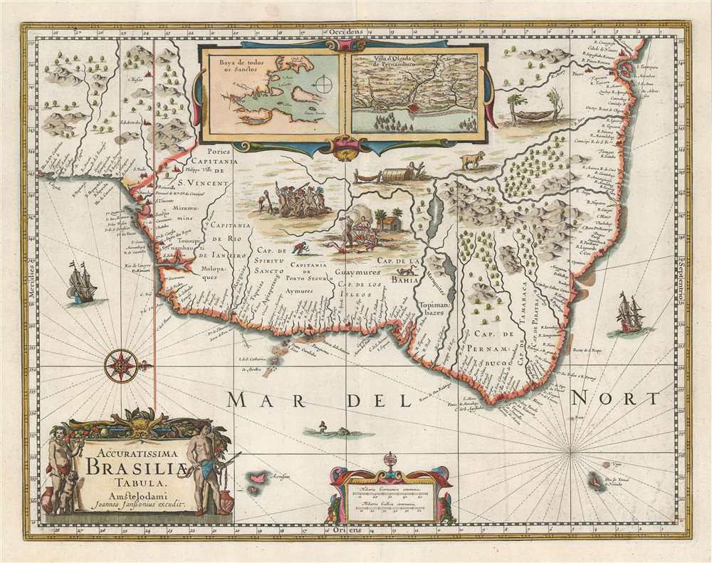
Accuratissima Brasiliae Tabula.
1644 (undated) 16 x 20 in (40.64 x 50.8 cm) 1 : 6800000]
1644 (undated) 16 x 20 in (40.64 x 50.8 cm) 1 : 6800000]
Description
Portuguese War and Dutch hegemony in Brazil. The map emerged from a short lived Dutch effort spearheaded by the Dutch West India Company (WIC), to take over Brazil and the Portuguese sugar trade. Oriented to the west, as one would approach Brazilian coasts from the sea, the map covers Sao Paulo in the south to Cidade de Nazare and São Luís in the north. The exterior is dotted with cities, ports and large navigable rivers, lending an aura of prosperity to the region. The interior, by contrast, exhibits grizzly vignette scenes of cannibalism, beheading, and tribal warfare, along with a few exotic animals. Inset maps at top center detail 'Baya de Todos os Sanctos' and 'Villa d'Olinda de Pernambuco,' both then under Dutch governance.
The Dutch-Portuguese War and the Sugar Trade
Between 1602 and 1663 Dutch corporate interests fought a series of wars with Portuguese Colonies in the Americas in an attempt to wrest global trade from the entrenched Portuguese. After the VOC achieved some success in the East Indies, they turned their attention to the Americas, founding the Dutch West India Company (Geoctroyeerde Westindische Compagnie, or WIC) in 1621. The Sugar Trade was then the world's most profitable business and was dominated by English, Spanish and Portuguese colonies in Brazil and the West Indies. The WIC invaded the capital of Brazil, São Salvador de Bahia de Todos os Santos, in 1624, but were driven out in 1625, less than a year later. In February of 1630, a second attempt was made with Commander Hendrick Corneliszoon Loncq landing a WIC fleet of 67 ships at Pernambuco. By February 16,1630, the Dutch were in possession of Olinda; by March all Portuguese resistance was over and the Dutch were masters of Recife, Olinda, and the island of Antonio Vaz. They renamed this part of Brazil 'New Holland,' and in 1651 expanded their hold on the region with the capture of São Luís. They conquest would be short lived. The Dutch proved much harder masters than the Portuguese leading to the 1645 Pernambucan Insurrection led by the mulatto land-owner João Fernandes Vieira, who proclaimed himself a Portuguese loyalist. Unable to maintain broad control of their Brazilian conquests against grassroots revolt, the WIC was fully expelled from Brazil in 1654. Ironically, it was preoccupation with the sugar plantations in Brazil that prevented the Dutch from holding onto their other major new world colony, then a backward fur trading outpost on a small island off the coast of North America - New Amsterdam, or as it became in 1664, New York.Publication History and Census
This map was originally engraved by Henricus Hondius (1597 - 1651) around 1633. The Hondius plates were later taken over by Jan Jansson (1588 - 1664), c. 1644, who retooled them and added his own imprint. Visscher later took over the plates and continued to publish the map largely unchanged. The map enjoyed a long subsequent print run with some editions appearing in atlases as late as the 1690s.CartographerS
Jodocus Hondius (October, 14 1563 - February 12, 1612) was an important Dutch cartographer active in the late 16th and early 17th centuries. His common name, Jodocus Hondius is actually a Latinized version of his Dutch name, Joost de Hondt. He is also sometimes referred to as Jodocus Hondius the Elder to distinguish him from his sons. Hondius was a Flemish artist, engraver, and cartographer. He is best known for his early maps of the New World and Europe, for re-establishing the reputation of the work of Gerard Mercator, and for his portraits of Francis Drake. Hondius was born and raised in Ghent. In his early years he established himself as an engraver, instrument maker and globe maker. In 1584 he moved to London to escape religious difficulties in Flanders. During his stay in England, Hondius was instrumental in publicizing the work of Francis Drake, who had made a circumnavigation of the world in the late 1570s. In particular, in 1589 Hondius produced a now famous map of the cove of New Albion, where Drake briefly established a settlement on the west coast of North America. Hondius' map was based on journal and eyewitness accounts of the trip and has long fueled speculation about the precise location of Drake's landing, which has not yet been firmly established by historians. Hondius is also thought to be the artist of several well-known portraits of Drake that are now in the National Portrait Gallery in London. In 1593, Hondius returned to Amsterdam, where he remained until the end of his life. In 1604, he purchased the plates of Gerard Mercator's Atlas from Mercator's grandson. Mercator's work had languished in comparison to the rival atlas, Theatrum Orbis Terrarum by Ortelius. Hondius republished Mercator's work with 36 additional maps, including several which he himself produced. Despite the addition of his own contributions, Hondius recognizing the prestige of Mercator's name, gave Mercator full credit as the author of the work, listing himself as the publisher. Hondius' new edition of Mercator revived the great cartographer's reputation and was a great success, selling out after a year. Hondius later published a second edition, as well as a pocket version called the Atlas Minor. The maps have since become known as the "Mercator/Hondius series". Between 1605 and 1610 Hondius was employed by John Speed to engrave the plates for Speed's The Theatre of the Empire of Great Britaine. Following Hondius' death in 1612, his publishing work in Amsterdam was continued by his widow and two sons, Jodocus II and Henricus. Later his family formed a partnership with Jan Jansson, whose name appears on the Atlasas co-publisher after 1633. Eventually, starting with the first 1606 edition in Latin, about 50 editions of the Atlas were released in the main European languages. In the Islamic world, the atlas was partially translated by the Turkish scholar Katip Çelebi. The series is sometimes called the 'Mercator/Hondius/Jansson' series because of Jansson's later contributions. Hondius' is also credited with a number of important cartographic innovations including the introduction of decorative map borders and contributions to the evolution of 17th century Dutch wall maps. The work of Hondius was essential to the establishment Amsterdam as the center of cartography in Europe in the 17th century. More by this mapmaker...
Jan Jansson or Johannes Janssonius (1588 - 1664) was born in Arnhem, Holland. He was the son of a printer and bookseller and in 1612 married into the cartographically prominent Hondius family. Following his marriage he moved to Amsterdam where he worked as a book publisher. It was not until 1616 that Jansson produced his first maps, most of which were heavily influenced by Blaeu. In the mid 1630s Jansson partnered with his brother-in-law, Henricus Hondius, to produce his important work, the eleven volume Atlas Major. About this time, Jansson's name also begins to appear on Hondius reissues of notable Mercator/Hondius atlases. Jansson's last major work was his issue of the 1646 full edition of Jansson's English Country Maps. Following Jansson's death in 1664 the company was taken over by Jansson's brother-in-law Johannes Waesberger. Waesberger adopted the name of Jansonius and published a new Atlas Contractus in two volumes with Jansson's other son-in-law Elizée Weyerstraet with the imprint 'Joannis Janssonii haeredes' in 1666. These maps also refer to the firm of Janssonius-Waesbergius. The name of Moses Pitt, an English map publisher, was added to the Janssonius-Waesbergius imprint for maps printed in England for use in Pitt's English Atlas. Learn More...
Condition
Very good. A vew minor verso reinforcements..
References
Rumsey 11755.129. Boston Public Library, Leventhal Center, G1007 .A75 1638. Van der Krogt, P. C. J., Koeman's Atlantes Neerlandici, (3 Vols),- #9850:1.2.