This item has been sold, but you can get on the Waitlist to be notified if another example becomes available, or purchase a digital scan.
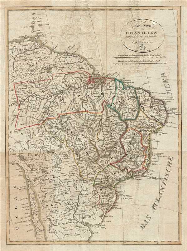
1822 Franz Pluth Map of Brazil
Brazil-pluth-1822$112.50

Title
Charte von Brasilien entworfen und gezeichnet nach C. F. Weiland.
1822 (dated) 16 x 12 in (40.64 x 30.48 cm) 1 : 16200000
1822 (dated) 16 x 12 in (40.64 x 30.48 cm) 1 : 16200000
Description
This is an 1822 Franz Pluth map of Brazil. The map depicts the region from the Caribbean islands of Martinique and St. Lucia to the Rio de la Plata and the Pampas and from Peru and the Pacific Ocean to the Atlantic Ocean. A highly detailed depiction of the region, Brazil is divided into different states, including Pernambuco. Innumerable rivers traverse the landscape, with the Amazon River system and the Uruguay River system dominating. The Andes are illustrated in a much less concrete manner, appearing to be ghosted in, between Chile and Argentina, which are labeled here as 'Rio de la Plata'. Several cities, such as Rio de Janeiro, Bahia, and Buenos Aires are labeled, along with numerous other coastal locations.
This map was created by Franz Pluth in 1822 and based on work by Carl Ferdinand Weiland.
This map was created by Franz Pluth in 1822 and based on work by Carl Ferdinand Weiland.
Cartographer
Franz Pluth (1800 - 1871) was an engraver based in Prague, the capital of the Kingdom of Bohemia, then part of the Habsburg Austrian Empire. Pluth was born in Prague and most likely died in Zbraslav. He was active as a map engraver until at least 1848. His work is similar in style to that of Karl Ferdinand Weiland, a prolific German engraver, with whom he may have worked. More by this mapmaker...
Source
Linder, F. L., Neueste Länder - und Völkerkunde, ein geographisches Lesebuch für alle Stände. , (Prague) 1820.
Linder's book is typically dated 1820, but contains maps dated between 1816 and 1825.
Condition
Very good. Light transferrence. Blank on verso.