
This item below is out of stock, but another example (left) is available. To view the available item, click "Details."
Details
1574 Ruscelli Map of Brazil
$650.00
1561 Ruscelli Map of Brazil
Brazil-ruscelli-1561$425.00

Title
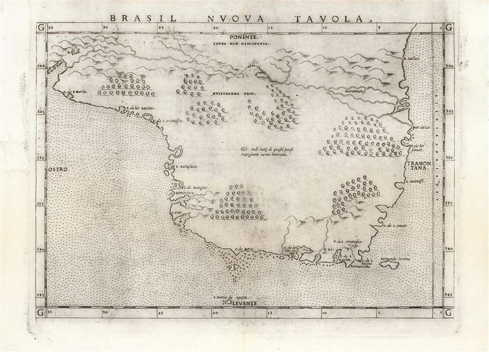
Brasil Nuova Tavola.
1561 (undated) 7 x 10 in (17.78 x 25.4 cm) 1 : 17000000
1561 (undated) 7 x 10 in (17.78 x 25.4 cm) 1 : 17000000
Description
This is a 1561 first plate issue of Girolamo Ruscelli's map of Brazil. It is among the first, detailed specific maps of any part of South America. While most of the maps in Ruscelli’s edition of Ptolemy were based on those appearing in Gastaldi's 1548 Ptolemy, this map was a new composition. It is predated only by the Ramusio woodcut map of 1556, whose geography is also credited to Gastaldi, and from which much of the detail of the Ruscelli is derived.
The Map
The map shares the Ramusio's westward orientation. Its coastal place names are also a close match to the Ramusio, and are indicative of the early period of Portuguese exploration and colonization prior to the establishment of the Captaincies by which Portugal would eventually administer the region. The coastline shows place names starting from the Rio de la Plata in the south, and the R. Sallec in the north, possibly the Orinoco. The Amazon river is shown, here using the name 'Marannon,' with its source in the 'Mullobamba' province marked with an exploding volcano. A key divergence between this map and the Ramusio is that while Ramusio chooses to illustrate natives harvesting brazil wood (the primary cash crop prior to the Portuguese establishment of sugarcane plantations) Ruscelli instead falls back on the sensationalistic portrayal of cannibalism, a notion which Vespucci’s letters entrenched. Brazil's abundant forests are depicted pictorially, but in the middle of the map the Italian text appears: 'Gli indi natij di questi paesi mangiano carne humana' (the Indians of these lands eat human flesh).The Transition From Italian to Global Geography
The cardinal directions are marked on the map, not on a compass rose, but at the four quarters of the map. The names used here for the directions - Tramontana, Ostro, Ponente and Levante - were typical for 16th century Italian cartographers, but would be abandoned in short order. These names were taken from the names of predominating winds in the Mediterranean: Tramontana, for example, referred specifically to the winds that came down across the Alps. While these had once been useful and communicative terms, their use far from Italian waters became increasingly nonsensical. 'Tramontana' would by the end of the 16th century be replaced by 'Septentrionale'.Publication History and Census
This map was engraved for the 1561 first edition of Ruscelli'sLa Geografia di Claudio Tolomeo. The maps of this edition were engraved two-to-a-plate, and consequently the platemark runs off the edge of the sheet at top. Later editions were engraved to a new plate. We see five examples of this separate map catalogued in OCLC.CartographerS
Girolamo Ruscelli (1500 - 1566) was an Italian polymath, humanist, editor, and cartographer active in Venice during the early 16th century. Born in Viterbo, Ruscelli lived in Aquileia, Padua, Rome and Naples before relocating to Venice, where he spent much of his life. Cartographically, Ruscelli is best known for his important revision of Ptolemy's Geographia, which was published posthumously in 1574. Ruscelli, basing his work on Gastaldi's 1548 expansion of Ptolemy, added some 37 new "Ptolemaic" maps to his Italian translation of the Geographia. Ruscelli is also listed as the editor to such important works as Boccaccio's Decameron, Petrarch's verse, Ariosto's Orlando Furioso, and various other works. In addition to his well-known cartographic work many scholars associate Ruscelli with Alexius Pedemontanus, author of the popular De' Secreti del R. D. Alessio Piemontese. This well-known work, or "Book of Secrets" was a compilation of scientific and quasi-scientific medical recipes, household advice, and technical commentary on a range of topics that included metallurgy, alchemy, dyeing, perfume making. Ruscelli, as Alexius, founded a "Academy of Secrets," a group of noblemen and humanists dedicated to unearthing "forbidden" scientific knowledge. This was the first known experimental scientific society and was later imitated by a number of other groups throughout Europe, including the Accademia dei Secreti of Naples. More by this mapmaker...
Giacomo Gastaldi (c. 1500 - October, 1566) was an Italian astronomer, cartographer, and engineer active in the second half of the 16th century. Gastaldi (sometimes referred to as Jacopo or Iacobo) began his career as an engineer, serving the Venetian Republic in that capacity until the fourth decade of the sixteenth century. During this time he traveled extensively, building a large library relating to voyages and exploration. From about 1544 he turned his attention to mapmaking, working extensively with Gextantiovanni Battista Ramusio, Nicolo Bascarini, and Giovanbattista Pedrezano, as well as taking private commissions for, among others, Venice's Council of Ten. He is credited with the fresco maps of Asia and Africa still extant in the map room of the Doge's Palace. Gastaldi was also one of the first cartographers to embrace copper plate over woodblock engraving, marking an important development in the history of cartography. His 1548 edition of Ptolemy's Geographia was the first to be printed in a vernacular; it was the first to be printed in copperplate. As with his Swiss/German contemporary Münster, Gastaldi's work contained many maps depicting newly discovered regions for the first time, including the first map to focus on the East Coast of North America, and the first modern map of the Indian Peninsula. His works provided the source for the vast majority of the Venetian and Roman map publishers of the 1560s and 70s, and would continue to provide an outsize influence on the early maps of Ortelius, De Jode, and Mercator. Learn More...
Source
Ruscelli, G., La Geografia di Claudio Tolomeo Alessandrino…, (Venice: Vincenzo Valgrisi) 1561.
Beginning in 1561, Girolamo Ruscelli published this important, expanded edition of Giacomo Gastaldi's 1548 Ptolemy. Its maps, engraved in Venice by Giulio Sanuto, were in the main based directly upon those in Gastaldi's 1548 work. The maps were larger format than Gastaldi's, however, and Sanuto's engraving was far clearer and more legible than those appearing in the 1548 work. There are some important additions that distinguish Ruscell's Ptolemy from Gastaldi's. Ruscelli's work contained a map of the habitable world according to Ptolemy, which the Gastaldi lacked; also, the double-hemisphere map appearing in the Ruscelli was new and did not appear in the Gastaldi. Ruscelli's modern map of England was based on the work of George Lily, rather than the Waldseemüller-derived map appearing in the Gastaldi; the Ruscelli is the earliest generally acquirable map of England based on knowledge from someone who lived there. In a fateful innovation, Ruscelli's work included Septentrionalium partium nova tabula,the first copy of Nicolo Zeno's 1558 fraud Carta da Navegar, which introduced a novel mapping of the north parts of the world, including the phantom islands of Frisland, Icaria, Drogeo and Estotiland. Had Ruscelli not copied the Zeno - which had a narrow, brief publication - this preposterous geography would have probably not taken hold. Its inclusion in Ruscelli's beautiful, authoritative and popular work would lead to the adoption of the Zeno map by Mercator, Ortelius, Plancius and their successors, baffling scholars for centuries. Ruscelli's Ptolemy had a long publication history, cementing the influence of the work. It appeared both in Italian and Latin editions, all printed in Venice, throughout the latter 16th century:
- 1561 La Geographia di Claudio Tolomeo Alessandrino, Italian. Venice, Vincenzo Valgrisi.
- 1562 Geographia Cl. Ptolemaei Alexandrini, Latin. Venice, Vincenzo Valgrisi.
- 1564 La Geographia di Claudio Tolomeo Alessandrino, Italian. Venice, Giordano Ziletti.
- 1564 Geographia Cl. Ptolemaei Alexandrini, Latin. Venice, Giordano Ziletti.
- 1574 La Geographia di Claudio Tolomeo Alessandrino, Italian. Venice, Giordano Ziletti.
- 1598 Geographia di Claudio Tolomeo Alessandrino, Italian. Venice, heirs of Melchoir Sessa.
- 1599 Geographia di Claudio Tolomeo Alessandrino, Italian. Venice, heirs of Melchoir Sessa.
Condition
Very good. Plate mark visible, running off sheet at top, as with all examples of the 1561 plate.
References
OCLC 165592119.