
1890 Bacon Map of Brighton, England


This item has been sold.
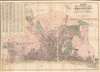
Bacon's New Ordnance Plan of Brighton.
'Oh, Brighton! Brighton! What a place thou art for love, liberty, and salt water.' - Jane Austen
- Digital Map Information
- Suitable for large format printing
- Full resolution TIFF file
- ICC color profile embedded
- Delivered instantly via download link
'Oh, Brighton! Brighton! What a place thou art for love, liberty, and salt water.' - Jane Austen
This is George Bacon's c. 1890 city plan or map of Brighton, England, at the height of its 19th-century tourism boom.A Closer Look
Coverage extends from Hove Drove (A2023) in the West to Riflebut Road (Marina Way) in the East and North as far as Hollingbury Castle (just South of the A27). The map notes streets, parks, civic buildings, and churches. Brighton's famous beach stretches along the bottom, with the pleasure pier (West) and the industrial pier (Chain) noted. There is a comprehensive index in the upper left. Today, as when this map was published, Brighton remains popular with British tourists.The Piers of Brighton
The map notes two piers: Chain Pier and West Pier. Chain Pier, better known as Royal Suspension Chain Pier, was construed in 1823 as a landing stage for packet steamers from Dieppe. The Chain Pier was damaged in a storm in 1896, and its remains were dismantled in 1899 to construct the now-famous Palace Pier, home to fairground rides, bars, restaurants, and deckchairs. West Pier, today in ruins, was Brighton's first pleasure pier, built during the boom in Brighton tourism in the 1860s. It was designed by architect Eugenius Birch as a place for seaside visitors to enjoy fresh sea air. It reached a peak in popularity in the early 20th century, but declined after World War II (1939 - 1945). Today, only an iron skeleton remains.Publication History and Census
This map was published in London by George Bacon's Geographical Establishment. Editions were issued from the 1870s, with minor updates and variations. Although the present example is undated, the presence of the piers narrows the publication date of the present example to the early 1890s. We note examples in the British Library and Bibliothèque Nationale de France. It is otherwise remarkably scarce, with no examples on the market.Cartographer
George Washington Bacon (1830 - 1922) was a London based book and map publisher active in the mid to late 19th century. Bacon's firm G.W. Bacon and Co. purchased the plates created by Edward Weller for the Weekly Dispatch Atlas then modified and updated them for several of their own important atlases, including The New Ordnance Atlas of the British Isles. In 1893, Bacon & Co. acquired the map publishing business of J. Wyld. Then, around the turn of the century, Bacon & Co. itself was folded into the Scottish publishing house of W.& A.K. Johnston. Further Details...
Condition
Very good. Some discoloration where previously attached to binder. Minor verso reinforcement along some fold lines.
References
OCLC 494805141.