1715 / 1733 Herman Moll 'Beaver Map' of the English Colonies in North America
BritishColoniesBeaverMap-moll-1715$11,000.00


Title
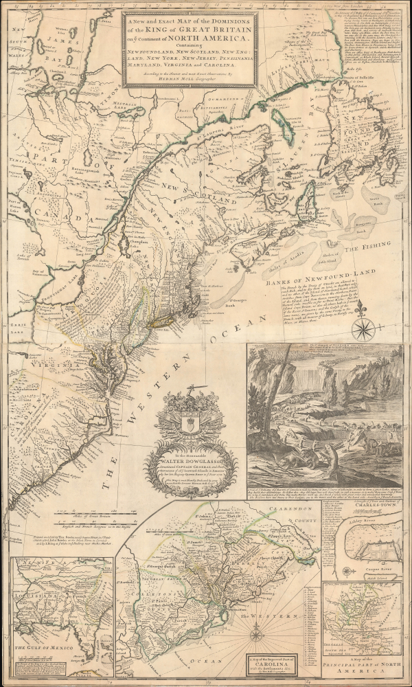
A New and Exact Map of the Dominions of the King of Great on ye Continent of North America. Containing Newfoundland, New Scotland, New England, New York, New jersey, Pensilvania, Maryland, Virginia and Carolina.
1715 (dated) 42.5 x 24.25 in (107.95 x 61.595 cm) 1 : 3600000
1715 (dated) 42.5 x 24.25 in (107.95 x 61.595 cm) 1 : 3600000
Description
This is Herman Moll's 1715 'Beaver Map' of the British Colonies in America, here in its 1733 state (see below). In addition to its iconic and namesake image of Niagara Falls and the rich American peltries, this map is also significant as one of the most accurate maps of the period and the first large-scale map to show American postal routes.
The map is dedicated to Walter Dowglass (Walter Douglas; 1670 - 1739), the British colonial governor of the Leeward Islands from 1711 to 1716.
A Closer Look
Coverage embraces the northeastern parts of North America, from Lake Erie to the Eastern Seaboard and from Newfoundland to St. Augustine.The British colonies are divided into Newfoundland, New Scotland, Cape Breton, New England, New York, East and West New Jersey, Pennsylvania, Maryland, Virginia, and Carolina. A large part of the territory northwest of Pennsylvania is segregated for the Iroquois League, staunch British allies who would go on to play a significant role in the French and Indian War (1754 - 1763).The map is dedicated to Walter Dowglass (Walter Douglas; 1670 - 1739), the British colonial governor of the Leeward Islands from 1711 to 1716.
The Beaver Inset
The map's namesake and the most striking visual element is the large vignette of Niagara Falls with an industrious colony of beavers in the foreground. The popular image capitalizes on European fascination with the lucrative fur trade, a source of seemingly endless wealth. The beaver, a fascinating creature itself, came to symbolize land management, wealth, and hard work. Moll did not originate this image. The view of Niagara Falls was first published in Utrecht in 1697 to illustrate explorer and conman Louis Hennepin's Nouvelle Decouverte d'un Tres Grand Pays Situe dans l'Amerique. Cartographer Nicholas de Fer adapted the image, adding the colony of beavers, for his 1713 Carte de La Mer du Sud et de La Mer du Nord. Moll derived the vignette from this source. After Moll, it was copied by Henri Chatelain for his 1719 Carte Très Curieuse de la Mer du Sud (Geographicus: CarteTresCurieuse-chatelain-1719).Louisiana Inset: Thomas Narine Cartography
The map features several significant insets, the leftmost of which, covering Louisiana, Florida, and modern-day South Carolina, is the most important, as it follows Indian Agent Thomas Nairne's important and early explorations of the interior of North Carolina. Narine was a Scottish militiaman and politician who emigrated to Carolina in 1695. He advocated an Indian policy of trade and religious conversion, which caused him to be appointed Agent of Indian Affairs in 1712. In this position, he spent as much as 10 months a year in the Carolina hinterlands, producing some of the most comprehensive inland cartography then available. Narine's appointment unfortunately coincided with Queen Anne's War (1702 - 1713), which included egregious abuses of the Yamassee Indians. While attempting to reopen trade in 1715, the Yamassee, eager for revenge, captured the trade delegation, which included Narine, and brutally tortured them to death via petit feu, a horrific torture involved burning pitch pine inserted under the sin. Narine reportedly lasted several days.Carolina Inset
The large central Carolina inset is also significant. Here, it has been updated over earlier states to include parishes. An alphanumeric key in the lower left identifies 35 plantations by the last names of their owners. An inset map of Charleston appears just to the right, with 20 key locations noted. A final inset, in the lower right, contextualizes the map within the continent.Historical Context
This map emerged in the wake of the 1713 Treaty of Utrecht, one of several that brought a close to the drawn-out War of Spanish Succession (1701 - 1714). In terms of America, it forced France to cede Nova Scotia, Newfoundland, and Hudson Bay to the British, as reflected here. All territory East of the Great Lakes and south of the St. Lawrence River is definitively British territory, making this map, as Pritchard notes, 'the primary exponent of the British position during the period.' A note regarding the treaty appears just above the beaver vignette.States and Piracies
H. Stevens and R. Tree, in their influential 'Comparative Cartography', delineate 5 states:- 1715: Imprint reads 'Sold by H. Moll over against Devereux Court without Temple Bar.' The Carolina inset does not display parishes. The Louisiana inset is undated and includes the note 'Cherecies 3000 men.'
- 1726: Same title and dated dedication as the 1715 issue. Imprint appears in two lines: 'Sold by H. Moll' and 'by I. King at ye Globe in ye Poultrey near Stock's Market.' Carolina and Louisiana insets match the earlier state. This version is found within a set of Moll's maps accompanied by a printed contents list dated 1726.
- 1731: Title and dedication unchanged from earlier editions. Imprint now expanded to three lines: 'Printed and Sold by Tho. Bowles...', 'John Bowles...', and 'by I King.' The Carolina inset now shows divisions. The 'Cherecies' annotation is dated 1730.
- 1735: Actually, by Geroge Grierson, a pirate copy, should not be considered part of the Moll series. Dedicated to Luke Gardiner, Deputy Vice Treasurer of His Majesty's Revenue in Ireland. Imprint reads 'Sold by Geo. Grierson, Printer to the King's Most Excellent Majesty, at the King's Arms and Two Bibles in Essex Street' (Dublin). The Carolina inset is divided, and the 'Cherecies' note retains the 1730 date. Unlike the London versions, this edition lacks a subsidiary title for the Niagara Falls inset.
- 1755: Retains the original title and dedication. Imprint once again in three lines: 'Printed and Sold by Tho. Bowles...', 'John Bowles and Son...', and 'by I King.' The Carolina inset remains divided, and the 'Cherecies' note is still dated 1730.
- 1715: Imprint reads 'Sold by H. Moll over against Devereux Court without Temple Bar.' The Carolina inset lacks parish divisions. The Louisiana inset is undated and includes the note 'Cherecies 3000 men.' Nova Scotia tapers to a point at its southern end. Casco Bay is shown offshore near the Saco River, and there are minimal place names along the northern coastline of 'Fundi Bay.'
- circa 1717: Features major revisions to the Nova Scotia and 'Fundi Bay' coastline, based on Nathaniel Blackmore's manuscript map. Annapolis Royal appears on a large inland bay with a narrow entrance. Casco Bay is now labeled on land, and over a dozen new place names are added along the northern coast of 'Fundi Bay.'
- circa 1717 (unverified): A hypothetical state mentioned by Stevens and Tree, but no known examples are documented.
- circa 1726: Now includes the imprint of H. Moll and I. King, 'at ye Globe in ye Poultry near Stock's Market,' indicating the addition of John King as a seller.
- circa 1730: The Carolina inset is updated to show parishes. The southeastern inset now contains the annotation 'Cehercies 3000 Men, one of ye Kings....' Georgia is not yet shown.
- circa 1730 (unverified): Another undocumented state noted in references, showing only John King's name, with H. Moll's name and address removed.
- circa 1733: The imprint of H. Moll is removed. Map now states it was 'Printed and Sold by Thos. Bowles... John Bowles... and I King.' The Carolina inset is revised to show counties instead of parishes.
- circa 1735: Similar to the 1733 version, but with the addition of Georgia.
- circa 1753: Same as previous state, but updated imprint lists 'Thos. Bowles... John Bowles and Son... and John King.'
Publication History and Census
This map was first compiled and published by Herman Moll in 1715, and at least 9 variant states followed. This present example conforms to Sevens and Tree 1715-c, or Bayton Williams 7 (1733), as above. The map was popular and is well-represented institutionally. It also appears on the market from time to time; however, due to low-quality paper, the awkward format of Moll atlases, and their large size, most examples are in extremely poor condition.CartographerS
Herman Moll (1654 - 1732) was an important 18th century map publisher and engraver based in London and Holland. Moll's origins are disputed with some suggesting he was born in the Netherlands and others Germany - the Moll name was common in both countries during this period. Most likely Moll was a German from Bremen, as his will, friends, and contemporaries suggest. What is known for certain is that he moved to London in 1678, possibly fleeing the Scanian War, where he worked as an engraver for Moses Pitt and other London map publishers. Around the turn of the century, Moll set up his own shop where he produced a large corpus of work known for its high quality and decorative flair. As a new émigré to England, Moll made himself more English than the English, and through his cartography proved a fierce advocate for his adopted nation. Most of Moll's early maps were issued as loose sheets that would be bound to order, however, he did publish several important atlases late in his career. Moll is said to have made the bold claim that without a doubt "California is an Island" and that he "had in [his] office mariners who have sailed round it." While California may not be an island (yet), it is true that moll had talent for attracting interesting friends and acquaintances. He frequented London's first stock exchange, Jonathan's Coffeehouse at Number 20 Exchange Alley, Cornhill. At the time Jonathan's was known as "a place of very considerable concourse for Merchants, sea faring Men and other traders" (Erleigh, The Viscount, The South Sea Bubble, Manchester: Peter Davies, Ltd., 1933, 21). Eventually this activity attracted the interest of stock brokers, who inspired by sailor's tales, sponsored the ill-fated South Sea Company, the world's first stock bubble. Moll's close circle, mostly from the Coffee House, included scientist Robert Hooke, the writers Daniel Defoe (Robinson Crusoe) and Jonathan Swift (Gulliver's Travels), the pirates William Dampier, William Hacke and Woodes Rogers, and the archeologist William Stukeley. Herman Moll's work was highly regarded for its decorative beauty and was pirated, most notably by the Irish publisher George Grierson, both in his lifetime and after his 1732 death at St. Clement Danes, London. More by this mapmaker...
The Bowles Family (fl. c. 1714 - 1832) were publishers and map sellers active in London from c. 1714 to c. 1832. The firm, under Thomas Bowles (fl. 1714 - 1763), John Bowles (1701 - 1779), Carrington Bowles (1724 - 1793), and as Bowles and Carver (fl. 1794 - 1832), produced a massive corpus of work that included numerous atlases, pocket maps, and wall maps. The Bowles publishing tradition was kept alive for four generations, starting with Thomas Bowles, a print engraver active in the late 17th century. His son, Thomas Bowles II, produced the firm's first maps at St. Paul's Churchyard, London. Thomas's brother, John Bowles (a.k.a. 'Old John Bowles' or 'Black Horse Bowles'), was also an active publisher established at no. 13 Cornhill. He is credited as one of the first publishers of William Hogarth's works. There, John's son, Carrington Bowles, was introduced to the trade. Carrington took over the Cornhill bookshop and eventually merged it with his uncle's shop in St. Paul's Churchyard. On Carrington's 1793 death, the business was passed to his son Henry Carrington Bowles (1763 - 1830), who partnered with his father's former apprentice Samuel Carver (1756 - 1841), renaming the firm 'Bowles and Carver'. Under this imprint, the firm continued to publish maps and atlases until 1832. Henry Carrington Bowles died in 1830, but Samuel Carver, himself in advanced years and poor health, kept it going for another 2 years before closing the business. Learn More...
Source
Moll, H., The World Described; or a New and Correct Sett of Maps, (London: Moll) 1732-33.
Condition
Very good. Original color faded. Light age toning, edge wear, and minor discoloration - as is common with this map.
References
Stevens, H. and Tree, R., 'Comparative Cartography', in Tooley, R. V., The Mapping of America, #55, page 87-88, state 1715-c. Library of Congress, G3300 1731.M6.