1816 Thomson Map Southern India
BritishIndiaSouthern-thomson-1816$200.00

Title
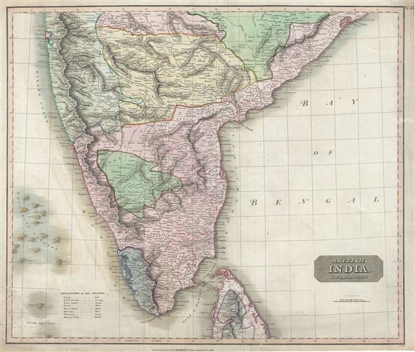
British India, Southern Part.
1816 (dated) 20.5 x 24 in (52.07 x 60.96 cm) 1 : 3000000
1816 (dated) 20.5 x 24 in (52.07 x 60.96 cm) 1 : 3000000
Description
This fascinating hand colored 1816 map by Edinburgh cartographer John Thomson depicts southern India. Covers from Bombay in the North to the northern part of Ceylon or Sir Lanka. The map is color coded according to the figures that dominated each region. British controlled areas are red, the territory of Nabob of Oude is orange, the Berar Rajah is green, the regions controlled by the King of Candy are brown, etc. Overall a spectacularly highly detailed map of this fascinating region. One of the finest maps of India to appear in the 19th century.
Cartographer
John Thomson (1777 - c. 1841) was a Scottish cartographer, publisher, and bookbinder active in Edinburgh during the early part of the 19th century. Thomson apprenticed under Edinburgh bookbinder Robert Alison. After his apprenticeship, he briefly went into business with Abraham Thomson. Later, the two parted ways, John Thomson segueing into maps and Abraham Thomson taking over the bookbinding portion of the business. Thomson is generally one of the leading publishers in the Edinburgh school of cartography, which flourished from roughly 1800 to 1830. Thomson and his contemporaries (Pinkerton and Cary) redefined European cartography by abandoning typical 18th-century decorative elements such as elaborate title cartouches and fantastic beasts in favor of detail and accuracy. Thomson's principle works include Thomson's New General Atlas, published from 1814 to 1821, the New Classical and Historical Atlas of 1829, and his 1830 Atlas of Scotland. The Atlas of Scotland, a work of groundbreaking detail and dedication, would eventually bankrupt the Thomson firm in 1830, at which time their plates were sequestered by the court. The firm partially recovered in the subsequent year, allowing Thomson to reclaim his printing plates in 1831, but filed again for bankruptcy in 1835, at which time most of his printing plates were sold to A. K. Johnston and Company. There is some suggestion that he continued to work as a bookbinder until 1841. Today, Thomson maps are becoming increasingly rare as they are highly admired for their impressive size, vivid hand coloration, and superb detail. More by this mapmaker...
Condition
Good. Minor spotting. Print crease along the center of map. Some damage and verso reinforcement near borders.
References
Rumsey 1007.046.