
This item below is out of stock, but another example (left) is available. To view the available item, click "Details."
Details
1623 Mercator / Hondius Map of the British Isles
$1,100.00
1595 Mercator Map of the British Isles: First Atlas Edition
BritishIsles-mercator-1595$600.00

Title
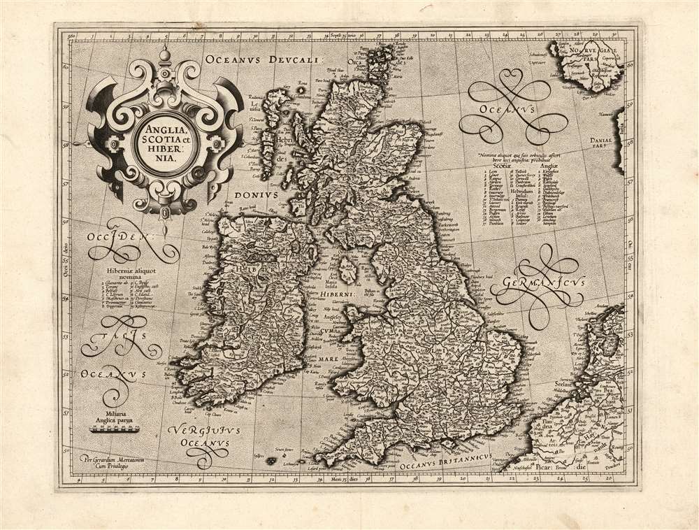
Anglia, Scotia et Hibernia.
1595 (undated) 12.75 x 16.25 in (32.385 x 41.275 cm) 1 : 4000000
1595 (undated) 12.75 x 16.25 in (32.385 x 41.275 cm) 1 : 4000000
Description
This is a superb example of the 1595 first atlas edition of Gerard Mercator's map of the British Isles, the definitive map of the British Isles for many subsequent decades.
A Closer Look
The present map represents a major update on Mercator's 1564 8-sheet wall map of the British Isles. He sourced much of his cartographic detail for England and Wales from the 1581 Christopher Saxton map and Ireland from Lawrence Nowell's unfinished works. Mercator's own delineation of Scotland would stand. According to Shirley, it would 'remain the standard outline, apart from minor improvements by Speed, until a new map of Scotland by Robert Gordon was published in 1654'.In Mercator's Own Hand
Although the atlas was published posthumously by Mercator's heirs, this is among the maps engraved personally by the master. Mercator's immaculate engraving features a baroque strapwork title cartouche in the upper left, beautiful calligraphic lettering, and fine stippling in the seas. Shirley hailed this work as 'one of restrained decoration and balance'. For the sake of legibility, Mercator had to assign a number of place names to numbered lists keyed to the map. The Latin note explains: 'The narrowness of space prohibited writing some names with their circles'.Publication History and Census
This map was engraved by Gerard Mercator after 1585, but was not published until 1595 by his heirs in the posthumous Atlas sive Cosmographicae. It was included in editions of the Mercator / Hondius atlas until 1630. The typography of the verso text conforms to the 1595 first edition of the atlas. Nineteen examples separate map appear in institutional collections in a variety of editions, but first edition examples are scarce.Cartographer
Gerard Mercator (March 5, 1512 - December 2, 1594) is a seminal figure in the history of cartography. Mercator was born near Antwerp as Gerard de Cremere in Rupelmonde. He studied Latin, mathematics, and religion in Rupelmonde before his Uncle, Gisbert, a priest, arranged for him to be sent to Hertogenbosch to study under the Brothers of the Common Life. There he was taught by the celebrated Dutch humanist Georgius Macropedius (Joris van Lanckvelt; April 1487 - July 1558). It was there that he changed him name, adapting the Latin term for 'Merchant', that is 'Mercator'. He went on to study at the University of Louvain. After some time, he left Louvain to travel extensively, but returned in 1534 to study mathematics under Gemma Frisius (1508 - 1555). He produced his first world map in 1538 - notable as being the first to represent North America stretching from the Arctic to the southern polar regions. This impressive work earned him the patronage of the Emperor Charles V, for whom along with Van der Heyden and Gemma Frisius, he constructed a terrestrial globe. He then produced an important 1541 globe - the first to offer rhumb lines. Despite growing fame and imperial patronage, Mercator was accused of heresy and in 1552. His accusations were partially due to his Protestant faith, and partly due to his travels, which aroused suspicion. After being released from prison with the support of the University of Louvain, he resumed his cartographic work. It was during this period that he became a close fried to English polymath John Dee (1527 - 1609), who arrived in Louvain in 1548, and with whom Mercator maintained a lifelong correspondence. In 1552, Mercator set himself up as a cartographer in Duisburg and began work on his revised edition of Ptolemy's Geographia. He also taught mathematics in Duisburg from 1559 to 1562. In 1564, he became the Court Cosmographer to Duke Wilhelm of Cleve. During this period, he began to perfect the novel projection for which he is best remembered. The 'Mercator Projection' was first used in 1569 for a massive world map on 18 sheets. On May 5, 1590 Mercator had a stroke which left him paralyzed on his left side. He slowly recovered but suffered frustration at his inability to continue making maps. By 1592, he recovered enough that he was able to work again but by that time he was losing his vision. He had a second stroke near the end of 1593, after which he briefly lost speech. He recovered some power of speech before a third stroke marked his end. Following Mercator's death his descendants, particularly his youngest son Rumold (1541 - December 31, 1599) completed many of his maps and in 1595, published his Atlas. Nonetheless, lacking their father's drive and genius, the firm but languished under heavy competition from Abraham Ortelius. It was not until Mercator's plates were purchased and republished (Mercator / Hondius) by Henricus Hondius II (1597 - 1651) and Jan Jansson (1588 - 1664) that his position as the preeminent cartographer of the age was re-established. More by this mapmaker...
Source
Mercator, G., Atlas sive Cosmographicae,(Amsterdam: Mercator) 1595.
Mercator's Atlas is one of the most important works in the history of cartography. Although in fact Ortelius was the first to publish a proper atlas, the Teatrum Orbis Terrarum, Mercator's work the first book to employ the term Atlas for a collection of maps. The term is derived both from the mythical titan, Atlas, who was forced to bear the world upon his shoulders, and the Libyan king, philosopher, and astronomer of the same name that, so the legend goes, constructed the first globe. Mercator dedicated the final 25 years of his life to compile the Atlas. He published two parts during his lifetime in 1585 and 1589, but the final part published posthumously by his son Rumold Mercator, in 1595. The map plates for the Atlas were later acquired by Jodocus Hondius who published the most complete and well known edition in 1606. It was Jodocus who popularized the Atlas and who did the most to elevate Gerard Mercator's name.
Condition
Excellent. Light soiling in margins. Else fine with generous margins and a bold, sharp strike.
References
OCLC 801754092. Rumsey 10501.067 (1607). Shirley, R., Early Printed Maps of the British Isles. A Bibliography, 1477-1650, 180.