This item has been sold, but you can get on the Waitlist to be notified if another example becomes available, or purchase a digital scan.
1922 F.M.S. Map of British Malaya (Malaysia)
BritishMalaya-fms-1922$750.00

Title
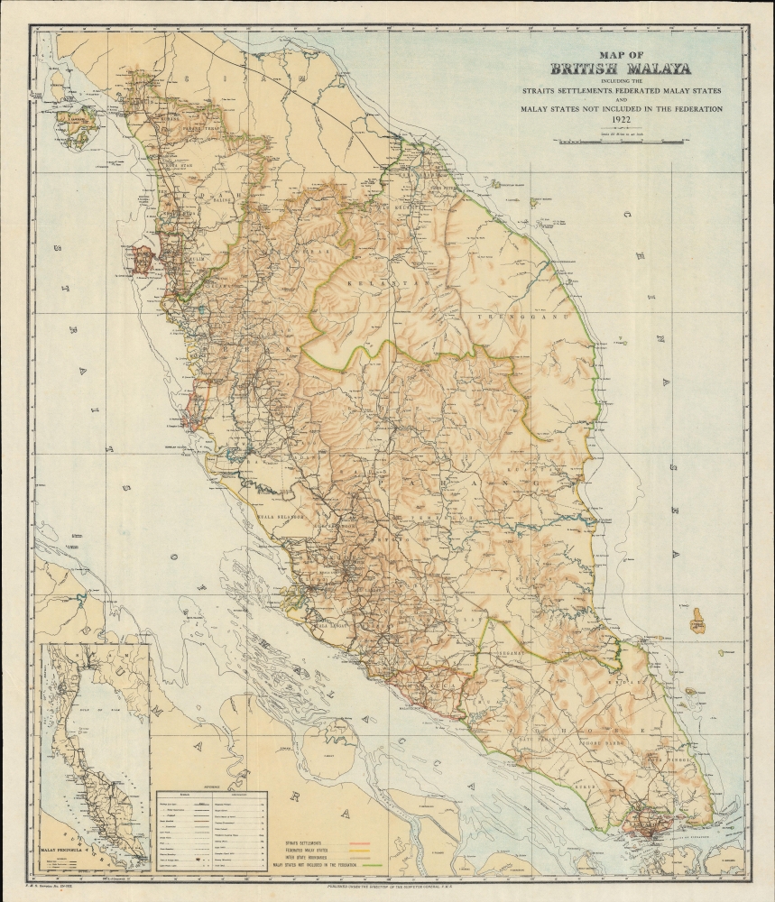
Map of British Malaya including the Straits Settlements Federated Malay States and Malay States Not Included in the Federation.
1922 (dated) 22 x 18.75 in (55.88 x 47.625 cm) 1 : 1267200
1922 (dated) 22 x 18.75 in (55.88 x 47.625 cm) 1 : 1267200
Description
A scarce 1922 map of Malaya, modern-day Malaysia, issued by the surveyor general of the Federated Malay States some 13 years after the British consolidated the northern four Malay states from Siam into the Unfederated Malay States. It illustrates the early days of the Malay tin and rubber booms.
A Closer Look
The map covers the Malay peninsula from the Thai / Siamese border to Singapore. A color-coding system breaks down the Malayan polities - red for the Straits Settlements (Singapore, Penang, Malacca, Dindings); Yellow for the Federated Malay States; Brown for interstate boundaries; and Green for states not incorporated into the FMS. The cartography around Terengganu, Johor, and Penang remains sparse. Kelantan, by contrast, is featured in exceptional detail, likely reflecting a recent British survey.Sungei Pahang
The Sungei Pahang is well mapped. This large river was the primary trade artery for centuries, allowing merchants who knew the river to bypass the most dangerous parts of the Straits of Malacca. The Pahang and Muar Rivers were nearly connected at Jempol, in Negeri Sembilan, as the Serting River flows into the Bera River, a tributary of the Pahang. The Jempol River flows into the Muar River. Trading boats from the Muar could continue their journey until they reached Kuala Pahang in Pekan or Kuala Lipis to continue into Terengganu, Kelantan, or Perak. The passage would not allow ocean-going vessels, but smaller vessels could use this route to successfully traverse the peninsula.Federated Malay States
The Federated Malay States (FMS) was a federation of four protected states in the Malay Peninsula: Selangor, Perak, Negeri Sembilan, and Pahang. The British government established the FMS in 1895, and it lasted until 1946, when the FMS, together with two of the former Straits Settlements (Malacca and Penang) and the Unfederated Malay States, formed the Malayan Union.Publication History
This map is quite rare. We have been able to identify only one other example, located in the collections of the National Library Board of Singapore. As part of a series, this map was issued in various states and editions from the late 19th through the mid-20th centuries.Cartographer
Federated Malay States Survey (1922 - 1945), better known as the F.M.S. Survey Department, was established in the early 20th century to produce detailed surveys of British Malaya and the Straits Settlements. The survey department had offices in most major Malayan ports, including Singapore, Kuala Lumpur, Penang (Georgetown), and Malacca. They were the first official survey organization to publish detailed scientifically produced maps of the region. More by this mapmaker...
Condition
Good. Light foxing.