This item has been sold, but you can get on the Waitlist to be notified if another example becomes available, or purchase a digital scan.
1935 Downtown Brooklyn Association Pictorial Map of Downtown Brooklyn
BrooklynDowntown-hagstrom-1935$187.50

Title
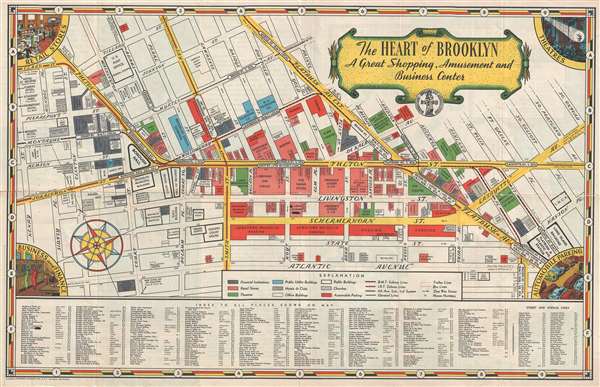
The Heart of Brooklyn A Great Shopping, Amusement and Business Center.
1935 (undated) 13.5 x 21 in (34.29 x 53.34 cm)
1935 (undated) 13.5 x 21 in (34.29 x 53.34 cm)
Description
A nearly unknown but wonderful 1935 pictorial map of downtown Brooklyn published for the Downtown Brooklyn Association and prepared by the Hagstrom Company. The map was drawn to promote the shopping and nightlife in downtown Brooklyn, with particular attention to retail stores, theaters, business opportunities, with, let's not forget, easy access to plentiful parking. The map centers on the Fulton Street Mall and extends from henry Street to Oxford Street and from Tillary Street to Atlantic Avenue. Color coding identifies Financial Institutions, Retail Sores, theaters, public buildings, hotels and clubs, office buildings, churches, and of course, parking. At this time the New York City Subway System was run by several small companies and here the BMT, the IRT, and the Trolley lines are all noted. Important business are identified by name on the map, with smaller business being identifiable via a large index below the map proper. On the verso there is a general map of Brooklyn, as well as a historical overview of the region. The copyright for this map was granted to Hagstrom Company on January 3, 1935.
Cartographer
Andrew Gunnar Hagstrom (1890 - September 24, 1977) was a map publisher based in Maspeth, Queens. Hagstrom was a Swedish immigrant who came to new York in 1909 where took work milking cows at a farm near Coney Island, Brooklyn. He then worked in the meat packing industry while taking a degree in commercial art at the New York Mechanics Institute. Afterwords he founded a drafting business in Manhattan, creating a map to illustrate his drafting skill help customers locate his shop. His map proved popular and he expanded operations, founding the Hagstrom Map Company (1916 - 1968) and issuing additional maps of various parts of New York City and the surrounding regions. By 1949, Hagstrom had issued more than 150 maps, guides, and atlases, most of which focused on New York. Hagstrom pioneered a cartographic style that exaggerated street size to increase clarity and create additional room for large print readable labeling. Even the New York Subway system hired Hagstrom to produce its map, which was in use from the 1940s to 1958. Hagstrom died in 1977, at the age of 81. Hagstrom was knighted by the King of Sweden. His company flourished until 1968 when it was acquired by Macmillan. The brand has since passed through multiple corporate portfolios and is currently the property by Kappa Publishing Group. More by this mapmaker...
Condition
Very good. Some creasing and wear on original fold lines. A couple of minor verso reinforcements.