This item has been sold, but you can get on the Waitlist to be notified if another example becomes available, or purchase a digital scan.
1687 Broadside Map of the 1686 Siege of Buda, Budapest, Hungary
Budapest-wening-1687$1,250.00

Title
Facies Budae, Regiae Metropolis Hungariae Ab Aquilinis Romani Imperii, et Bavarici Leonis unguibus, simul et viribus Brandeburgicis unanimiter coadunatis, belli flammis undique deformatae, et Infidelium manibus, auxiliante gratiâ Divinâ, victricibus demúm armis ereptae. Die 2. Sept. Anno 1686.
1687 (dated) 23 x 22.25 in (58.42 x 56.515 cm) 1 : 8352
1687 (dated) 23 x 22.25 in (58.42 x 56.515 cm) 1 : 8352
Description
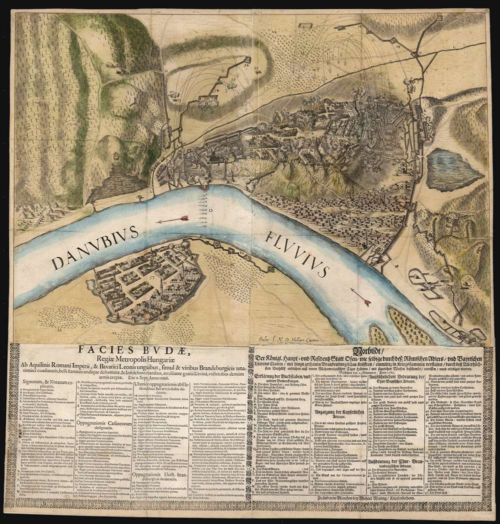
This is an extremely rare political broadsheet map of Budapest, Hungary. It was engraved by Michael Wening to celebrate the September 2, 1686 victory of combined Holy League forces led by the Duke of Lorraine and the Elector of Bavaria over the Turkish forces occupying Buda, Hungary.
A Closer Look
The map is oriented to the west, bisected by the Danube with Buda on the top and Pest on the lower left. The forbidding, rocky terrain of Buda's fortress is clearly and accurately depicted, and both the defending fortifications and the siege works built by the Imperial attackers are laid out with precision - evidence that the map was composed not only by a firsthand observer, but also by a military engineer familiar with the progress of the battle. It was drawn by Ludwig Nicolaus von Hallart, a nobleman serving as quartermaster with the Saxon army. He was among the five thousand Saxon soldiers hired out to support the Imperial armies in Hungary, and which took part in the siege.The Siege of Buda
The engraving depicts the the June 20, 1686 culmination of the Siege of Buda. Imperial troops numbering about 61,000 attacked Turkish-held Buda, defended by a force of 14,000. The greater part of the Imperial army was under the command of Charles V, Duke of Lorraine, while a smaller, largely Bavarian force was commanded by Maximilian Emmanuel. The map illustrates the constant bombardment of the city by the Imperial armies, and an alphabetical and numerical key is used to notate locations and events of particular importance, with descriptions printed in both Latin and German. The decisive battle on September 2 was characterized by Lorraine's breakthrough in the northwest part of the wall, while the Bavarians were stalled in the south. While the maneuvers of both parts of the besieging army are dramatically illustrated, it is worth noting that while Charles of Lorraine is nowhere mentioned - the actions of his army are credited to 'Caesareans,' the usual terminology for the Imperial army. This stands in sharp contrast to the abundant deeds ascribed to the Elector of Bavaria, Maxmilian II Emanuel. For example, the Elector of Bavaria is credited - item 'Q' - for having personally, with a single bomb, destroyed a Turkish powder magazine, killing more than a thousand defenders and ruining part of the fortress by fire. The map - one of perhaps a dozen provided by Hallart to Wening for publication - provides a convincingly accurate portrayal of the siege. The text, however, would have been composed by Wening - who as Munich's court engraver had every motivation to elevate the deeds of his patron Maxmilian Emanuel.A Superb Engraving
Wening's work is a magnificently detailed copperplate engraving. Not only the camps and fortifications, but the city's suburbs, vineyard-covered hills, and rugged topography are vigorously and clearly presented. The bombardment of the city is indicated by pictorial trajectories of shells from the encampments into the fortress and explosions among the city walls add to the drama of the view.Publication History and Census
This broadside was engraved and printed in Munich by Michael Wening, court engraver to the Bavarian Elector in Munich. Such broadsides were separately issued, and seldom survive. We see only one example of this map in OCLC, held by the British Library. The BL has dated the document to 1688, but most institutions date other Wening / Hallar broadsides from this series to 1687, and it is very possible that they were actually printed even closer to the events depicted.CartographerS
Hallart, Ludwig Nicolaus von (1659 - 1727) was a Saxon nobleman, diplomat and soldier. Little is known of his education and youth, but he appears to have been an able engineer with a specialty in fortifications. He drew a series of maps and views between 1685 and 1688 chronicling Germman battles with the Turkish Empire along the Danube, which would be published by Michael Wening: the publisher was court engraver for Maxmilian II Emanuel, the Elector of Bavaria, for whom Wening produced engravings to celebrate the Elector's victories in these wars against the Ottoman Empire. In 1700 he was sent to lead the siege works at Narva: the Russian defeat of the first battle of Narva saw him captured by the Swedes. He was freed in a prisoner exchange in 1705. Hallart remained in Russian service. He foughtin the campaigns in Little Russia in 1708-09, and with the Saxon army in Germany in 1712-13. He produced writtend descriptions of a number of his campaigns, including an unprinted account of the Great Northern War which has been found in the National Archives in Saint Petersburg. More by this mapmaker...
Michael Wening (July 11, 1645 – April, 18 1718) was a Bavarian engraver known for his many depictions of important places in the Bavaria of his day, including cityscapes and views of stately homes, castles and monasteries. Michael Wening was born on 11 July 1645 in Nuremberg, son of butcher and meat inspector Balthasar and Katharina Wening. Michael was the sole survivor of 13 children. His education is not known, but he did not follow his father's trade, instead becoming an engraver. He learned the art of cityscapes while working for the Nuremberg publisher Fürst and Hoffman. He left Nuremberg in the spring of 1668, and is first mentioned in Munich in December 1669, where he applied for work as a court engraver. In 1672 Wening was working part-time at the court as a quartermaster, but by 1675 he was being called court engraver.
As court engraver, he also undertook small commissions for a number of clients. He also founded a publishing company at this time on his own, producing for example an illustrated calendar. In the 1680s, as part of his duties as court engraver in Munich, produced a series of engravings on behalf of his patron Maxmilian II Emanuel, the Elector of Bavaria. These were blatamnt propaganda, celebrating the Elector's victories in the wars against the Ottoman Empire. Starting in 1696 he began work on a four-volume city atlas of the Electorate of Bavaria; the first volume focusing on Munich was published November 1701, containing 358 engravings. The work proved overly ambitious, and he ran out of investors. Moreover, Bavaria would fall under Austrian occupation during the War of the Spanish Succession: the court engraver of an exiled court cannot be expected to have flourished. Perhaps as a result of his efforts to produce the rest of his work at his own cost, he lived his last yearsi n extreme poverty. His heirs would complete the last three volumes in 1721, 1723 and 1726. The final work would contain 846 views of cities, towns, monasteries, palaces, castles and manors. The copper plates are owned by the State of Bavaria, and survive in the Bavarian State Office for Survey and Geoinformation in Munich. Learn More...
Condition
Good. Letterpress sheets joined to copperplate map as issued; old reinforcements to folds, some manuscript reinstatement of text at lower left. Old color, possibly refreshed.
References
OCLC 556742319.