This item has been sold, but you can get on the Waitlist to be notified if another example becomes available, or purchase a digital scan.
1579 Ortelius Map of Burgandy (Bourgogne), France and Parts of Switzerland
Burgundy-ortelius-1579$112.50

Title
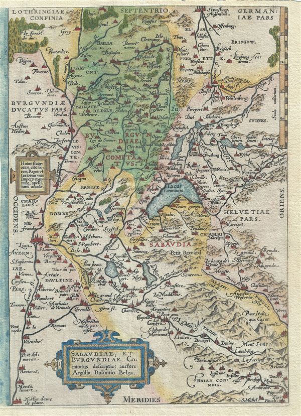
Sabaudiae, et Burgundiae Comitatus Descriptio.
1579 (undated) 12 x 9 in (30.48 x 22.86 cm) 1 : 1220000
1579 (undated) 12 x 9 in (30.48 x 22.86 cm) 1 : 1220000
Description
This is a rare 1579 Abraham Ortelius map of Burgundy (Bourgogne), France. Centered on Lake Geneva, Ortelius' map covers from Lyon, France to La Chaux-de-Fonds, Switzerland and from Vesoul to Rivoli, Italy. The modern region of Haute-Savoie and the neighboring department of Savoie were, until 1860, part of the Kingdom of Sardinia. The color coding in this map depicts the territorial boundaries of the time. The region of Burgundy in France is famed for producing the world's finest wines. The map features a decorative title cartouche in the lower left quadrant. Shows the region in wonderful detail with attention to forests, cities, lakes, rivers, villages and other topographical features. Cartographically based on the map by Boileau de Bouillion, this map was published in Antwerp by A. Ortelius in 1579 for issue in his seminal atlas Theatrum Orbis Terrarum.
Cartographer
Abraham Ortelius (April 14, 1527 - June 28, 1598) also known as Ortels, was a cartographer, geographer, and cosmographer of Brabant, active in Antwerp. He was the creator of the first modern atlas, Theatrum Orbis Terrarum and is a seminal figure in the history of cartography. Along with Gerard Mercator and Gemma Frisius, he was a founder of the Netherlandish school of cartography. His connections with Spain - culminating in his 1575 appointment as Royal Cartographer to King Phillip II of Spain - gave him unmatched access to Spanish geographical knowledge during a crucial period of the Age of Discovery. Ortelius was born in 1527 in Antwerp. In 1547 he entered the Antwerp Guild of Saint Luke as an illuminator of maps. He began trading in books, prints, and maps, traveling regularly to the Frankfurt book and print fair, where in 1554 he met Mercator. He accompanied Mercator on journeys throughout France in 1560 and it was at this time, under Mercator's influence, that he appears to have chosen his career as a scientific geographer. His first published geographic work appeared in 1564, an eight-sheet cordiform world map. A handful of other maps preceded the 1570 publication of the first edition of the Theatrum Orbis Terrarum, which would prove to be his life work. Appearing with but 53 maps in its first edition, Ortelius' work expanded with new maps added regularly. By 1592, it had 134 maps. Many of Ortelius' maps remained the standard for nearly a century. He traveled extensively, but his genius was as a compiler, locating the best informed maps on which to base his own. His contacts throughout Europe and extending even (via the Portuguese) to the Far East were formidable. Moreover, many of his maps were based on his own scholarship, particularly his historical works. His theories of geography were particularly ahead of his time with respect to the notion of continental drift, the possibility of which he mused on as early as 1596, and which would be proven correct centuries later.
In a sense his greatest achievement was his successful navigation of the religious and political violence endemic to his city throughout his adult life: The Dutch Revolt, or Eighty Years' War (1568 - 1648), fully embroiled Antwerp. Although outwardly and officially recognized as Catholic (Arias Montanus vouched for Ortelius' Catholic orthodoxy prior to his appointment as Royal Geographer), Ortelius was able to separate himself from the religious furor which characterized the war in the low countries. Ortelius showed a glimpse of himself in a letter to a friend, regarding humanist Justus Lipsius: 'I do not know whether he is an adherent of the Pope or a Calvinist, but if he has ears to hear, he will neither be one nor the other, for sins are committed on both sides'. Ortelius' own explorations of Biblical history in his maps, and the Christogram contained in his own motto, suggest him to be a religious man, but his abjuration of political religious authorities mark him as an individualist. His tombstone at St Michael's Præmonstratensian Abbey in Antwerp bears the inscription, Quietis cultor sine lite, uxore, prole. ('served quietly, without accusation, wife, and offspring.') More by this mapmaker...
Source
Ortelius A., Theatrum Orbis Terrarum, (Antwerp) 1579.
Condition
Good. Overall toning. Blank on verso. Framer's tape on verso. Unusual margin coloration on left side of map.