This item has been sold, but you can get on the Waitlist to be notified if another example becomes available, or purchase a digital scan.
1902 Poole Brothers Railroad Map of the United States
BurlingtonRoute-poolebros-1902$400.00

Title
Burlington Route.
1902 (dated) 32.75 x 47.75 in (83.185 x 121.285 cm) 1 : 3600000
1902 (dated) 32.75 x 47.75 in (83.185 x 121.285 cm) 1 : 3600000
Description
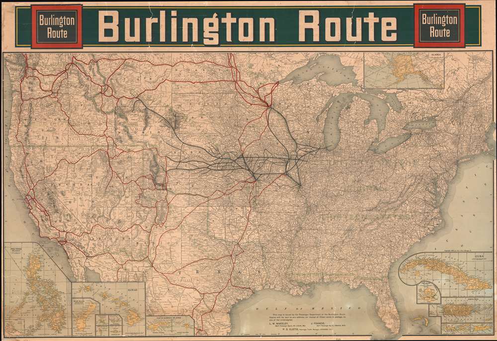
Upon first glance, this 1902 Poole Brothers railroad map of the United States details the country's extensive rail network and gives pride of place to the Burlington Northern. Thick black lines trace the Burlington's main routes and dots mark all its whistle stops, while thinner lines identify nearly all the small railroads in operation across the county. However, when more closely examined, green overprinting jumps off the page and block lettering proclaims the history of America's westward expansion.
A Lesson in American History and the Spanish-American War
Aside from detailing the critical rail network snaking its way from coast to coast, Poole Brothers decided to include a history lesson on this piece. Published only four years after the Spanish-American War, pride at yet another armed victory pulsed through the American people. New territories, including the Philippines, Guam, and Puerto Rico, had all been ceded by Spain as part of the 1898 peace agreement. The U.S. also annexed the Hawaiian Islands that year, and Midway and Wake Islands followed in 1900. Poole Brothers included insets of all this newly gained land and elected to carry the theme through to the continental United States. The green overprinting referenced above divides the U.S. into seven different sections and paints a picture of America's piecemeal expansion. These parcels were bought (Louisiana Purchase, Gadsden Purchase), annexed (Texas), and ceded as spoils of war (Mexican Cession), which allowed the United States to dominate a large portion of North America from the Atlantic to the Pacific.Publication History and Census
This map was created by Poole Brothers and 'issued by the Passenger Department of the Burlington Route' in 1902. Two examples are cataloged in the OCLC and are part of the institutional collections at the Wisconsin Historical Society and the Denver Public Library.Cartographer
Poole Brothers (1878 - 1968) were a Chicago based firm active in the late 19th and early 20th century with an initial focus on promotional railroad maps. Poole Brothers was founded by George Amos Poole (March 20, 1843 – September 7, 1918). In 1868, Poole, along with his uncle William H. Rand (1828 - 1915) and Andrew McNally (1836 - 1904), purchased the Chicago Tribune's job printing plant and formed the firm Rand McNally. In 1878, he left Rand McNally to form, with his brother William H. Poole, Poole Brothers, a direct competitor to Rand McNally for the lucrative railroad business. Like many of its competitors, Poole Brothers maintained an office on Chicago's Printer's Row (downtown Loop district). Their earliest known work is an 1880 map of Yellowstone National Park. In 1887, Poole Brothers, Andrew McNally, and several others formed the United Typothetae of America, a master printers association. In 1848, they were cited, along with Rand McNally and George Cram, by the Federal Trade Commission for price fixing. Their earliest known work is an 1880 map of Yellowstone National Park. Afterward they went on to produce a vast range of maps and other print products including tickets, cards, coupons, and restaurant menus. In time Poole Brothers merged with Newman-Randolph, which was then acquired by the American Can Company in the early 1960s. The American Can Company liquidated its printing concerns later in the same decade. More by this mapmaker...
Condition
Average. Laid down on archival tissue. Many old cracks and repairs. Even toning except stripe along bottom of the map.
References
OCLC 793040651.