This item has been sold, but you can get on the Waitlist to be notified if another example becomes available, or purchase a digital scan.
1888 Crocker Map of California
California-crocker-1888$550.00

Title
Geographical and Climatic Map of the State of California.
1888 (dated) 32.5 x 28 in (82.55 x 71.12 cm) 1 : 1400000
1888 (dated) 32.5 x 28 in (82.55 x 71.12 cm) 1 : 1400000
Description
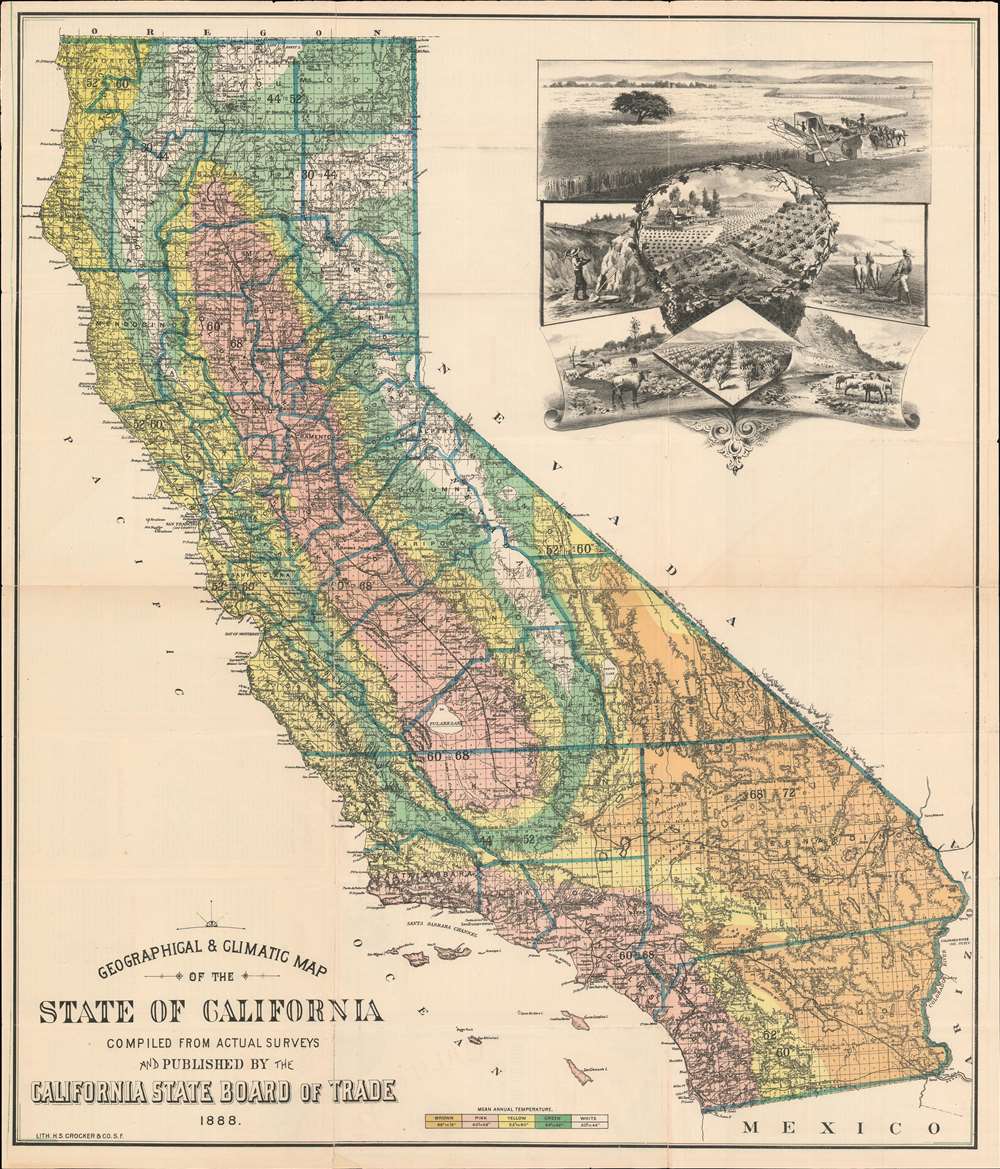
One of the earliest depictions of viticulture (wine-making) in California, this is the 1888 Henry Smith Crocker and California State Board of Trade map of California. The large cartouche in the upper right features centrally large fields of grapes. The map itself offers color-coding to highlight different areas of the state based on the mean annual temperature. Thick blue lines outline counties, and individual townships are illustrated. Railroad lines and major roads snake their way across the state, and rivers, lakes, mountains are represented and labeled as well.
An Impressive Viticulture Vignette
Created and published by the California State Board of Trade, an incredible vignette situated on the upper right promotes California's agricultural industries with the goal of enticing people to emigrate. A vineyard bordered by grapevines takes center stage, making this one of the first promotional pieces to place California's wine-making industry front and center. Views of orchards, livestock grazing in fields, a farmer plowing a field, and another farmer using an early combine harvester to harvest a field of wheat surround this groundbreaking central image. A miner, with a pickaxe and shovel, appears at left, and a train passes in the background. Although the California Gold Rush had long since ended, the prospect of earning one's fortune through mining was still prevalent in the state.Crocker's Subsequent Map of 1893
It is noteworthy that five years later, in 1893, Crocker issued another large format lithograph map of California. That map, far better known and more common in the trade, is often erroneously hailed as 'earliest, if not the earliest, cartographic representation of wine making in California' has a similar cartouche and aesthetic. However, while the present map is intended for the official board of trade, Crocker's next major map was designed to promote the business interests of his brother, Central Pacific railroad magnate Charles Crocker (1822 - 1888). Given their obvious similarities, we can only assume that work on the present 1888 map influenced the 1893 production.Publication History and Census
This map was created and published by the California State Board of Trade in 1888. The Henry Smith Crocker and Company printed it. This map is well represented institutionally, but is extremely rare on the private market, as we have been unable to discover another instance when it has entered the private market.Cartographer
Henry Smith Crocker (January 31, 1832 - July 18, 1904) was an American printer, publisher, and railroad investor active in northern California in the middle to late 19th century. Crocker followed the Gold Rush to California, settling in Sacramento in the 1850s. He established his printing concern, H. S. Crocker, in 1856. Apparently his first office was little more than a tent with a small sign. Crocker relocated to San Francisco in 1871. He became extremely wealthy almost overnight by leveraging his ties to the Central Pacific Railroad, which is brother, Charles Crocker (1822 - 1888) founded. In 1885, Crocker constructed a large five-story printing factory, powered by his own private steam plant, then the largest and most sophisticated printing concern on the west coast. Crocker's prosperity continued and by the time he died in 1904, he was the head of a large and wealthy family. Although Crocker passed on, his company, H.S. Crocker, continued to operate and remains active to this day. More by this mapmaker...
Condition
Good. Verso repairs and reinforcements along some of the original fold lines. Minor chip along bottom border reinstated.
References
Rumsey 4104.001. OCLC 25891134.