
1927 Jo Mora Large Pictorial Map of California

This item has been sold.
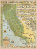
California. This whimsical Carte of Topographic and Historic intention, depicting that fabled isle of Montalvo's dream - the El Dorado of '49 - the glorious California we know and love...
Mora's rare 3rd map - large format California.
- Digital Map Information
- Suitable for large format printing
- File Size: 82.98 MB
- File Type: ZIP / TIFF
- ICC color profile embedded
- Delivered instantly via download link
Mora's rare 3rd map - large format California.
A beautiful example of Jo Mora's scarce larger first map of California, issued in 1927 by A. M. Robertson of San Francisco. This is one of Mora's earliest pictorial maps, following on the popularity of his Monterrey Peninsula (1926) and 17-Mile Drive (1927) maps, and as such, is one of his rarest - especially in good condition.A Closer Look
Coverage embraces California in full. Despite being a general map focused on historical anecdotes and folklore, it is nonetheless replete with Mora's characteristic hyper-local humor that only a lifelong Californian would instantly appreciate. Some highlights include:- Near San Diego, three young men head to Tijuana with the subtext 'How dry I am!', clearly a reference to cross-border Prohibition Era (1920 - 1933) shenanigans.
- Warships near San Diego reflect its 1920s establishment as a major Pacific naval port.
- The goats of Catalina Island.
- Divorcees on the alimony trail heading towards Reno.
- Mount Lassen during a period of intense eruptions from 1914 to 1921.
- The Salinas Rodeo - Mora was a cowboy himself and a regular participant in the rodeo.
- Captain Jack and the Lava Beds War, a reference to the Modoc War (1872 - 1873), one of the most tragic episodes of Native American resistance to U.S. military forces.
- An intense illustration of the destructive force of hydraulic gold mining near Sacramento.
Pictorial content along the left border details' El Camino Real', the Spanish colonial era route that connected the 21 Spanish missions, presidios, and pueblos from San Diego to Sonoma.
Publication History and Census
This map was drawn by Jo Mora and published in 1927 by Alexander Mitchell Robertson of San Francisco. This is one of Mora's earliest and rarest pictorial maps. The map is scarce to the market in good condition.Cartographers
Joseph 'Jo' Jancito Mora (October 22, 1876 – October 10, 1947) was an Uruguayan born artist active in California during the first half of the 20th century. Mora immigrated to California as a young man. He studied art in Boston and, after graduating, worked there briefly before relocating to California. In cartographic circles Mora is known for pioneering the 20th century pictorial map. In a series he referred to as his 'cartes,' published between in 1926 and 1942, Mora developed a pictorial style that combined cartography with colorful cartoonish image of local figures, folklore, history, and natural wonders. His earliest maps were commissioned by the Hotel Del Monte and included California's Playground and The Seventeen Mile Drive. As he matured as a cartographer, his work became increasingly dense, often packed with tiny figures, each expressive of some aspect of regional life. Mora, often called the 'Renaissance man of the West' also worked as an illustrator, muralist, sculptor, photographer, and writer. His masterpiece is considered to be the Father Serra Cenotaph, a bronze and marble sculpture at the Memorial Chapel in El Carmelo Mission, Carmel, California. His map work included Monterey Penninsula (1927), and Seventeen Mile Drive (1927), California (1927), Grand Canyon (1931), Yosemite (1931), Yellowstone (1936), Carmel-By-The-Sea (1942), California (1945) (large and small versions), Map of Los Angeles (1942), among others. Further Details...
Alexander Mitchell Robertson (April 1855 - February 12, 1934) was an influential San Francisco bookseller and publisher. Known as 'Aleck', Robertson was considered the 'dean of San Francisco booksellers'. Robertson was known for his patronage of San Francisco writers. Robertson was born in Ontario, Canada, but he had deep connections to San Francisco - his father, a highland Scot named William David Robertson, came to San Francisco in 1849 to seek his fortune in the Gold Rush and, reportedly, 'made his pile.' The Robertson family returned to San Francisco in the 1860s, and A. M. grew up there, studying at Lincoln Grammer School. He fell in love with books, taking a job at Beech's Bookstore in San Francisco's Union Square when he was just 12 years old (he later took over the firm in 1875 as Billings, Harbon and Company, of which the 'company' was Robertson). From 1881, he spent time gold prospecting in Arizona and New Mexico and was one of the first settlers of Tombstone, Arizona. By 1886, he was back in San Francisco, where he bought out Billings and Harbon, establishing himself with a partner as Pierson and Robertson. The bookstore, later renamed A. M. Robertson, became a literary mecca, frequented by such luminaries as Jack London, Robert Louis Stevenson, Rudyard Kipling, and Brete Harte. He was a regular at the Bohemian Club. Robertson died in San Mateo after a lingering illness. Further Details...
Condition
Very good. Slight edge wear.
References
Rumsey 8560.000. Gilmore, J., Jo Mora's Cartes and Maps, #M3.