1849 Imray Nautical Map of California Coast - Gold Rush!
CaliforniaCoast-imary-1849$3,900.00


Title
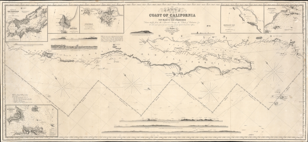
Chart of the Coast of California form San Blas to San Francisco.
1849 (dated) 27 x 58 in (68.58 x 147.32 cm) 1 : 1950000
1849 (dated) 27 x 58 in (68.58 x 147.32 cm) 1 : 1950000
Description
The 1849 first edition, published for the California Gold Rush, of the James Imray blueback nautical map of the coast of California. This map, by Imray, predates any American charts of the California coast and, when it was issued, was the best obtainable chart for ambitious 49ers en route to the gold regions.
As a working nautical chart, this map includes pencil annotations related to at least two voyages, one from Mexico to San Francisco (likely a Gold Rush Run) and another that heads out to sea. There is some manuscript labeling, but it is mostly unreadable. It also, curiously, includes a correction regarding the location of Socorro Island.
A Closer Look
Oriented to the west, coverage embraces the California coast from roughly Cape Corrientes in Mexico north to Trinidad Bay, California, including all of Baja and the Gulf of California. Insets detail San Francisco Bay, Monterey, Magdalen Bay, Mazatlan, Guaymas, and the entrance to San Francisco Harbor (Golden Gate). On the peninsula, the Mission de San Francisco and the fortifications at the Presidio are noted, but no further settlement or construction is evident. Moreover, while this map does not delineate the Gold Regions, it does show the Sacramento River outlet into San Pablo Bay, the water route which many fortune-seekers followed to the gold fields.As a working nautical chart, this map includes pencil annotations related to at least two voyages, one from Mexico to San Francisco (likely a Gold Rush Run) and another that heads out to sea. There is some manuscript labeling, but it is mostly unreadable. It also, curiously, includes a correction regarding the location of Socorro Island.
The California Gold Rush
The discovery of gold at John Sutter's mill by James Wilson Marshall (1810 - 1885) in January 1848 was one of the most definitive moments in American history. Coming at the end of the Mexican-American War (1846 - 1848), the timing of the discovery could not have been more propitious. The combination of new seemingly unlimited territory and the lure of gold led to a stampede of adventurers, prospectors, merchants, and homesteaders eager for a new life on the frontier. The Gold Rush was not limited to Americans crossing the Great Plains. European, Australian, and even Chinese immigrants rushed into California hungry for their part of the great strike. This Great Migration transformed the United States in the span of just a few years from a former colony into an expansive transcontinental nation on the cusp of becoming a world power.Blueback Charts
Blueback nautical charts began appearing in London in the late 18th century. Bluebacks, as they came to be called, were privately published large format nautical charts known for their distinctive blue paper backing. The backing, a commonly available blue manila paper traditionally used by publishers to wrap unbound pamphlets, was adopted as a practical way to reinforce the low-quality paper used by private chart publishers in an effort to cut costs. That being said, not all blueback charts are literally backed with blue paper. The earliest known blueback charts include a 1760 chart issued by Mount and Page and a 1787 chart issued by Robert Sayer. The tradition took off in the early 19th century, when British publishers like John Hamilton Moore, Robert Blachford, James Imray, William Heather, John William Norie, Charles Wilson, David Steel, R. H. Laurie, and John Hobbs, among others, rose to dominate the chart trade. Bluebacks became so popular that the convention was embraced by chartmakers outside of England, including Americans Edmund March Blunt and George Eldridge, as well as Scandinavian, French, German, Russian, and Spanish chartmakers. Blueback charts remained popular until the late 19th century, when government-subsidized organizations like the British Admiralty Hydrographic Office and the United States Coast Survey began issuing their own superior charts on high-quality paper that did not require reinforcement.Publication History and Census
This map was published by James Imray in 1849. It is the first edition, almost certainly compiled in a hurry to take advantage of interest in the California Gold Rush. It is, of note, 'Chart No. 8', referring to the final installment of Imray's series on the west coast of America. Subsequent editions followed in 1851, 1853, 1854, and 1862. We note an example of the 1849 edition at the New York Public Library, UC Berkeley, Yale, and UC Santa Cruz.Cartographer
James Imray (May 16, 1803 - November 15, 1870) was a Scottish hydrographer and stationer active in London during the middle to latter part of the 19th century. Imray is best known as a the largest and most prominent producer of blue-back charts, a kind of nautical chart popular from about 1750 to 1920 and named for its distinctive blue paper backing (although not all charts that may be called "blue-backs" actually have a blue backing). Unlike government charts issued by the British Admiralty, U.S. Coast Survey, and other similar organizations, Imray's charts were a private profit based venture and not generally the result of unique survey work. Rather, Imray's charts were judicious and beautiful composites based upon pre-existing charts (some dating to the 17th century) and new information gleaned from governmental as well as commercial pilots and navigators. Imray was born in Spitalfields, England, the eldest son of a Jacobite dyer also named James. Imray did not follow his father profession, instead apprenticing to William Lukyn, a stationer. He established himself as a bookseller and bookbinder at 116 Minories Street, where he shared offices with the nautical chart publisher Robert Blanchford. In 1836 Imray signed on as a full partner in Blanchford's enterprise, christening themselves Blanchford & Imray. At this time the Blanchford firm lagged far behind competing chart publishers Norie and Laruie, nevertheless, with the injection of Imray's marketing savvy the firm began a long rise. James Imray bought out Blanchford's share in 1846, becoming the sole proprietor of the chart house, publishing under the imprint of James Imray. Relocating in 1850 to larger offices at 102 Minories, Imray was well on track to become the most prominent chart publisher in London. In 1854, when Imray's 25 year old son, James Frederick Imray, joined as a full partner, the firm again changed its imprint, this time to James Imray and Son. The elder Imray was a master of marketing and was quick to respond to trade shifts and historic events. Many of his most successful charts were targeted to specific trade routes, for example, he issued charts entitled "Cotton Ports of Georgia" and "Rice Ports of India". Other charts emerged quickly following such events as the 1849 California Gold Rush. Imray's rise also coincided with the development of governmental mapping organizations such as the Admiralty and the U.S. Coast Survey, whose work he appropriated and rebranded in practical format familiar to navigators. Imray's death in 1870 marked a major transition in the firm's output and began its decline. Though Imray's son, James Frederick, excelled at authoring pilot books he had little experience with charts and issued few new publications. Most James Frederick Imray publications issued from 1870 to 1899 were either revisions of earlier maps prepared by his father or copies of British Admiralty charts. Charts from this period are recognizable as being less decorative than the elder Imray's charts following the stylistic conventions established by the Admiralty. The Admiralty itself at the same time began to rise in prominence, issuing its own official charts that were both cheaper and more up to date than those offered by private enterprises. By the end of the century the firm was well in decline and, in 1899 "James Imray and Son" amalgamated with the similarly suffering "Norie and Wilson", which was itself acquired by Laurie in 1904. Today it continues to publish maritime charts as "Imray, Laurie, Norie and Wilson". More by this mapmaker...
Condition
Very good. Relaid on fresh linen. Tracks of voyages marked in pencil.
References
OCLC 25155637, 912594844.