This item has been sold, but you can get on the Waitlist to be notified if another example becomes available, or purchase a digital scan.
1772 Vaugondy / Diderot Map of California and Alaska ( Anian & Quivira )
Californie-vaugondy-1772$250.00

Title
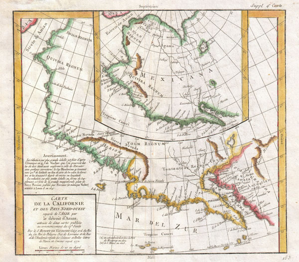
Carte De La Californie et Des Pays Nord-Ouest separes de L'Asie par le Detroit d'Anian, extraite de deux cartes publiees au commencement de 17e Siecle.
1772 (dated) 12 x 13.5 in (30.48 x 34.29 cm)
1772 (dated) 12 x 13.5 in (30.48 x 34.29 cm)
Description
A very interesting 1772 map of the western part of North America by Vaugondy. Includes two contrasting maps, both drawn from larger 17th century maps by Visscher, covering from Cabo san Lucas northward along Baja California to modern day Alaska and the Arctic.
The larger map lists many place names, both factual and fictional, along the California coast. These include the Bay of San Miguel (San Diego), Bay de Feugos, C. Mendocino, Costa Brava, and others. Inland details include a number of river systems extending northwards from the Bay of California, the Sierra Nevada Mountains, and the Kingdoms of Tontoneteac Regnum, Tolm Regnum, Albion, Quivira Regnum and Anian Regnum.
Many of these lands are mythical. Anian, for example, near modern day Alaska, was first mentioned in the journals of Marco Polo and was first noted on maps by the Venetian Cartographer Bolognini Zaltieri in 1561. Later the term was popularized in a John Donne poem, 'Anyan if I go west by the North-West passage.' In the 18th century, it was interpreted as the Bering Strait by cartographers, successfully transitioning it from the realms of fiction to cartography. Anian presupposed the existence of a Northwest Passage and, as such, was entirely mythical, though the lands that are now Alaska long bore that name.
Just south of Anian Regum is the kingdom of Quivira. Quivira was supposedly an ancient city of gold located somewhere in North America. The conquistador Coronado spent years searching for it only, some say, to arrive and find it to be little more than an American Indian wigwam town.
The smaller of the two maps, derived from the Visscher and Pierre Plantius's map of 1641, bears a considerably greater resemblance to actuality. Includes many actual destinations along the coast including the Cape of San Francisco. An entrance through the 'Estreto de Anian' seems to lead to an Arctic Sea, thus suggesting a Northwest Passage. This map also labels both Anian and Quivira, even going so far as to note the city of Quivira, capital of the great mythical kingdom.
This map is part of the 10 map series prepared by Vaugondy for the Supplement to Diderot's Encyclopédie, of which this is plate 4. This seminal map series, exploring the mapping of North American and specifically the Northwest Passage was one of the first studies in comparative cartography.
CartographerS
Robert de Vaugondy (fl. c. 1716 - 1786) was French may publishing from run by brothers Gilles (1688 - 1766) and Didier (c. 1723 - 1786) Robert de Vaugondy. They were map publishers, engravers, and cartographers active in Paris during the mid-18th century. The father and son team were the inheritors to the important Nicolas Sanson (1600 - 1667) cartographic firm whose stock supplied much of their initial material. Graduating from Sanson's maps, Gilles, and more particularly Didier, began to produce their own substantial corpus. The Vaugondys were well-respected for the detail and accuracy of their maps, for which they capitalized on the resources of 18th-century Paris to compile the most accurate and fantasy-free maps possible. The Vaugondys compiled each map based on their own geographic knowledge, scholarly research, journals of contemporary explorers and missionaries, and direct astronomical observation. Moreover, unlike many cartographers of this period, they took pains to reference their sources. Nevertheless, even in 18th-century Paris, geographical knowledge was limited - especially regarding those unexplored portions of the world, including the poles, the Pacific Northwest of America, and the interiors of Africa, Australia, and South America. In these areas, the Vaugondys, like their rivals De L'Isle and Buache, must be considered speculative or positivist geographers. Speculative geography was a genre of mapmaking that evolved in Europe, particularly Paris, in the middle to late 18th century. Cartographers in this genre would fill in unknown lands with theories based on their knowledge of cartography, personal geographical theories, and often dubious primary source material gathered by explorers. This approach, which attempted to use the known to validate the unknown, naturally engendered rivalries. Vaugondy's feuds with other cartographers, most specifically Phillipe Buache, resulted in numerous conflicting papers presented before the Academie des Sciences, of which both were members. The era of speculative cartography effectively ended with the late 18th-century explorations of Captain Cook, Jean Francois de Galaup de La Perouse, and George Vancouver. After Didier died, his maps were acquired by Jean-Baptiste Fortin, who in 1787 sold them to Charles-François Delamarche (1740 - 1817). While Delamarche prospered from the Vaugondy maps, he defrauded Vaugondy's window Marie Louise Rosalie Dangy of her rightful inheritance and may even have killed her. More by this mapmaker...
Denis Diderot (October 5, 1713 - July 31, 1784) was a French Enlightenment era philosopher, publisher and writer. Diderot was born in the city of Langres, France and educated at the Lycée Louis le Grand where, in 1732, he earned a master of arts degree in philosophy. Diderot briefly considered careers in the clergy and in law, but in the end chose the more fiscally challenge course of a writer. Though well respected in philosophical circles Diderot was unable to obtain any of the government commissions that commonly supported his set and consequently spent much of his life in deep poverty. He is best known for his role in editing and producing the Encyclopédie . The Encyclopédie was one of the most revolutionary and impressive works of its time. Initially commissioned as a translation of Ephraim Chambers' Cyclopaedia, or Universal Dictionary of Arts and Sciences, Diderot instead turned into a much larger and entirely new work of monumental depth and scope. Diderot's Encyclopédie was intended to lay bare before the common man the intellectual mysteries of science, art and philosophy. This revolutionary mission was strongly opposed by the powers of the time who considered a learned middle class it a threat to their authority. In the course of the Encyclopédie production Diderot was imprisoned twice and the work itself was officially banned. Nonetheless, publication continued in response to a demand exceeding 4000 subscribers. The Encyclopédie was finally published in 1772 in 27 volumes. Following the publication of the Encyclopédie Diderot grew in fame but not in wealth. When the time came to dower his only surviving daughter, Angelique, Diderot could find no recourse save to sell his treasured library. In a move of largess, Catherine the II Russia sent an emissary to purchased the entire library on the condition that Diderot retain it in his possession and act as her "librarian" until she required it. When Diderot died of gastro-intestinal problems 1784, his heirs promptly sent his vast library to Catherine II who had it deposited at the Russian National Library, where it resides to this day. Learn More...
Claes Jansz Visscher (1587 - 1652) established the Visscher family publishing firm, which were prominent Dutch map publishers for nearly a century. The Visscher cartographic story beings with Claes Jansz Visscher who established the firm in Amsterdam near the offices of Pieter van den Keer and Jadocus Hondius. Many hypothesize that Visscher may have been one of Hondius's pupils and, under examination, this seems logical. The first Visscher maps appear around 1620 and include numerous individual maps as well as an atlas compiled of maps by various cartographers including Visscher himself. Upon the death of Claes, the firm fell into the hands of his son Nicholas Visscher I (1618 - 1679), who in 1677 received a privilege to publish from the States of Holland and West Friesland. The firm would in turn be passed on to his son, Nicholas Visscher II (1649 - 1702). Visscher II applied for his own privilege, receiving it in 1682. Most of the maps bearing the Visscher imprint were produced by these two men. Many Visscher maps also bear the imprint Piscator (a Latinized version of Visscher) and often feature the image of an elderly fisherman - an allusion to the family name. Upon the death of Nicholas Visscher II, the business was carried on by the widowed Elizabeth Verseyl Visscher (16?? - 1726). After her death, the firm and all of its plates was liquidated to Peter Schenk. Learn More...
Source
Supplement to Diderot, D., Encyclopédie, ou dictionnaire raisonné des sciences, des arts et des métiers; or Robert de Vaugondy, G., Recueil de 10 Cartes Traitant Particulierement de L'Amerique du Nord, (Paris) 1779.
Condition
Very good condition. Original centerfold. Wide clean margins. Original platemark visible. Blank on verso.
References
Pedley, Mary Sponberg. Bel et Utile: The Work of the Robert de Vaugondy Family of Mapmakers. 473. Falk, Marvin W., Alaskan Maps: A Cartobibliography of Alaska to 1900, #1772-3. Wagner, Henry R., The Cartography of the Northwest Coast of America to the Year 1800,, 632. Wheat, C., The Mapping of the Transmississippi West, 1540-1861, 159. Phillips, P.L. (Atlases) 1195.4.