This item has been sold, but you can get on the Waitlist to be notified if another example becomes available, or purchase a digital scan.
1781 Buache de Neuville Map of North America, the Arctic, Alaska, and Siberia
CalifornieKamtchatka-buache-1781$400.00

Title
Nouvelle Carte de la Partie Septentrionale du Globe, comprise entre le Kamtchatka et la Californie.
1781 (dated) 11 x 16 in (27.94 x 40.64 cm) 1 : 35000000
1781 (dated) 11 x 16 in (27.94 x 40.64 cm) 1 : 35000000
Description
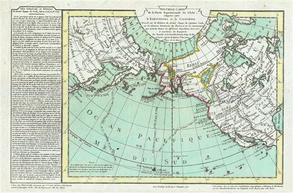
Truly one of the scarcest and most extraordinary maps we have ever seen, this is Jean-Nicholas Buache de Neuville's 1781 map of the North Pacific, North America, and Siberia. This map is so dense with cartographic curiosity that it is as if Buache de Neuville has attempted to resurrect every cartographic speculation of the previous 300 years in the light of the ground breaking discoveries of Captain Cook. Following Cook's discoveries, the map actually offers a reasonably accurate approximation of the California, British Columbia and Alaskan coastline. The forms of Alaska and the Aleutian Islands are instantly recognizable and in this regard the map offers significantly greater sophistication than most previous works. Prince William Sound, Cooks Inlet, the Aleutian Islands, and the Bering Strait are clearly represented. It is in the interior of North America that Buache de Neuville's map becomes really interesting. The little known territory north of Mexico and west of the Mississippi, as well as the Canadian Arctic west of Hudson and Baffin Bays, has been illustrated with a wealth of speculation, some dating to the early maps of Mercator, but most referencing the previous 30 years of French speculation regarding the region.
Most of the really interesting cartography here involves Buache de Neuville's reinterpretation of the apocryphal De Fonte discoveries. The De Fonte legend first appeared in a 1706 English publication entitled Memoirs of the Curious. This short-lived magazine published a previously unknown account by a supposed Spanish Admiral named Bartholomew de Fonte. De Fonte is said to have sailed up the Pacific coast of North America in 1640. On this voyage he apparently discovered a series of gigantic lakes, bays, and rivers heading eastward from the Pacific towards Hudson Bay. The De Fonte story relates how, on one of these great inland lakes, he met with a westward bound ship from Boston that must have come through the Northwest Passage. Today, based upon inaccuracies and falsities, we know the entire De Fonte article to have been a fabrication, nevertheless, it set 18th century Europe afire with speculation that a Northwest Passage must indeed exist. Even such luminaries as Benjamin Franklin wrote long defenses of De Fonte.
Buache de Neuville has here placed the entrances to De Fonte's lake and river system in Cook's Inlet near today's Anchorage, much further north than most previous maps. Cook's Inlet was not fully explored by the final Cook expedition and was thus presumed to be the only possible entrance to the Northwest Passage. Here Buache de Neuville has associated both Cook's Inlet and Prince William Sound with the De Fonte Discoveries. We can recognize the Lac de Fuentes as well as Lac Belle, and the Rio de los Reyes. Many of the water communications here are conjectural but would later be echoed by Peter Pond and published in a 1790 map publicizing his fur trading expeditions. Lac de Fuentes seems to roughly correspond with Great Slave Lake. The factual Mackenzie River is nowhere in evidence, but a second fictional river, also appearing in the Pond map and extending westward towards Prince William Sound and Cook's Inlet, may well have its first expression here.
Another legacy of the De Fonte voyage appears further north in the form of passages extending northwards from Cook Inlet towards Lac Velasco, thence via a river communication to the high Arctic, as well as another ship's route passing through the Bering Strait and then heading eastwards toward Baffin Bay. This refers to the travels of Pedro de Bernarda, a sub-Captain under Admiral De Fonte. According to the legend, on the 22nd of June, De Fonte dispatched Bernarda northwards where he discovered a large lake full of islands, which he named 'Velasco' after the Governor of New Spain. He then traveled through the Bering Strait and sailed eastward almost as far as Baffin Bay. The travels of Bernarda are marked here skirting the coasts of Alaska and the Canadian Arctic. There is also a river named after him called the Rio de Bernarda. Like De Fonte, Bernarda was most likely fictional but his explorations were nonetheless used by Captain James Ross in his 1835 argument for a possible Northwest Passage.
Buache de Neuville places a secondary communication, here highlighted in green, between the Strait of Juan de Fuca and Lac de Fuente. Unlike De Fonte, many of De Fuca's discoveries, as well as the man himself, ring of truth. The Strait of Juan de Fuca exists and, though it was named much later, roughly corresponds to De Fuca's actual descriptions. Cook notes sailing past the entrance described by De Fuca but did not explore the strait further. Had he done so he would have found himself in the Puget Sound region later explored by George Vancouver and Amiel Weeks Wilkes. Instead, as with Cook's Inlet, Buache de Neuville capitalizes on another of Cook's omissions by speculatively linking the Strait of Juan de Fuca with De Fonte's discoveries. However, to his credit, Buache de Neuville does admit that this passage is a 'Communication conjucturee'.
Curiously, a speculative river course extends inland from the Pacific somewhere between Cape Mendocino and Cape Blanc (Cape Perpetua) where it widens into an inland sea. A river from said sea continues eastwards to Lake Mozeemleck. Though the sea is ghosted in, uncolored, and unlabeled, it is clearly a final vestige of the supposed Sea of the West, a popular cartographic idea influenced by the explorations of De Fonte, De Fuca, and the 17th century overland explorer Baron de Lahonton. Lahonton in particular seems to have influenced Buache de Neuville in composing this map for the river, which reaches Lac Mozeemleck, is a direct reference to the Voyages of Lahonton, who describes the Mozeemleck as thus:
Buache de Neuville resurrects the term 'Conibas' to refer to the lands south of Lac de Fuente. 'Conibas' is rarely seen on maps postdating 1700 and was first used on the Thevet map of 1575. Mercator later presented the lake in his 1595 speculative map of the northern Polar Regions. Conibas is usually mapped as a large lake, with a central island that has an outlet into a great Arctic Bay. Conibas appeared on a number of earlier maps including its first appearance on the Thevet Map of 1575. Thevet is known to have met with Jacques Cartier and may have derived the lake from these conversations. Some suggest that the term refers to 'Cornibotz,' an alternate name for Wampum shells. Be that as it may, Buache de Neuville's choice to resurrect the term is clearly an effort to place the discoveries of De Fonte, especially Lac de Fuente, into a historical context as well as well as using the Mercator name, however dated, to validate his own cartographic speculation.
Along the coast of modern day British Columbia, Buache de Neuville maps 'Fusang des Chinois'. Fusang of Fousang is a region first documented by the Chinese Buddhist missionary Hui Shen in the 5th century. Hui Shen describes a land some 20,000 Chinese Li (c. 8000 km) east of the China coast. Fousang is described in considerable detail in the 7th century Book of Liang by Yao Silian. There are also accounts that the land was settled c. 220 BC by a Chinese Emperor of the Han Dynasty. In later days Fusang was commonly used in Chinese poetry to designate Japan, however earlier references keep it distinct. In any case, Hui Shen's description of Fusang with regard to distance and geography corresponds more with the coastlands of North America than with Japan. The French historian Joseph de Guignes in his 1761 article Le Fou-Sang des Chinois est-il l'Amerique? promoted this idea. Cartographers of the era, including Buache de Neuville, Zatta, Robert de Vaugondy, and others, embraced the idea and it was included in many subsequent maps of the region.
South of the ghosted and unlabeled 'Sea of the West' Buache de Neuville maps Aztlan. This is the legendary homeland of the Aztec peoples. According to legend on exactly May 24, 1065 CE, the Mexica (Aztec) began an epic migration from their ancestral homeland, Aztlan, which translated means 'Place of Reeds' or 'Place of Egrets,' to the shores of Lake Texcoco, in Mexico’s Central Mesa. There they founded the city of Tenochtitlan which in time spawned the vast Aztec Empire famously encountered by Hernan Cortez several hundred years later. The migration, which seems to have lasted some 250 years, is comparable in scope to the biblical wanderings of the Israelites recorded in Exodus. The term occasionally appears on several early maps but tends to have been abandoned in the 18th century. Buache de Neuville presentation of Aztlan here resurrects the term and foreshadows Alexander von Humboldt's more in depth study of the Aztlan legend in the early 19th century. Like Humboldt, Buache de Neuville may have been familiar with Gemelli's 1706 description of Aztlan when he added it here.
All in all this is a remarkable map and the swan song of the great age of French speculative cartography. It was published in Jean-Claude Dezauche's 1781 Atlas Geographique.
Most of the really interesting cartography here involves Buache de Neuville's reinterpretation of the apocryphal De Fonte discoveries. The De Fonte legend first appeared in a 1706 English publication entitled Memoirs of the Curious. This short-lived magazine published a previously unknown account by a supposed Spanish Admiral named Bartholomew de Fonte. De Fonte is said to have sailed up the Pacific coast of North America in 1640. On this voyage he apparently discovered a series of gigantic lakes, bays, and rivers heading eastward from the Pacific towards Hudson Bay. The De Fonte story relates how, on one of these great inland lakes, he met with a westward bound ship from Boston that must have come through the Northwest Passage. Today, based upon inaccuracies and falsities, we know the entire De Fonte article to have been a fabrication, nevertheless, it set 18th century Europe afire with speculation that a Northwest Passage must indeed exist. Even such luminaries as Benjamin Franklin wrote long defenses of De Fonte.
Buache de Neuville has here placed the entrances to De Fonte's lake and river system in Cook's Inlet near today's Anchorage, much further north than most previous maps. Cook's Inlet was not fully explored by the final Cook expedition and was thus presumed to be the only possible entrance to the Northwest Passage. Here Buache de Neuville has associated both Cook's Inlet and Prince William Sound with the De Fonte Discoveries. We can recognize the Lac de Fuentes as well as Lac Belle, and the Rio de los Reyes. Many of the water communications here are conjectural but would later be echoed by Peter Pond and published in a 1790 map publicizing his fur trading expeditions. Lac de Fuentes seems to roughly correspond with Great Slave Lake. The factual Mackenzie River is nowhere in evidence, but a second fictional river, also appearing in the Pond map and extending westward towards Prince William Sound and Cook's Inlet, may well have its first expression here.
Another legacy of the De Fonte voyage appears further north in the form of passages extending northwards from Cook Inlet towards Lac Velasco, thence via a river communication to the high Arctic, as well as another ship's route passing through the Bering Strait and then heading eastwards toward Baffin Bay. This refers to the travels of Pedro de Bernarda, a sub-Captain under Admiral De Fonte. According to the legend, on the 22nd of June, De Fonte dispatched Bernarda northwards where he discovered a large lake full of islands, which he named 'Velasco' after the Governor of New Spain. He then traveled through the Bering Strait and sailed eastward almost as far as Baffin Bay. The travels of Bernarda are marked here skirting the coasts of Alaska and the Canadian Arctic. There is also a river named after him called the Rio de Bernarda. Like De Fonte, Bernarda was most likely fictional but his explorations were nonetheless used by Captain James Ross in his 1835 argument for a possible Northwest Passage.
Buache de Neuville places a secondary communication, here highlighted in green, between the Strait of Juan de Fuca and Lac de Fuente. Unlike De Fonte, many of De Fuca's discoveries, as well as the man himself, ring of truth. The Strait of Juan de Fuca exists and, though it was named much later, roughly corresponds to De Fuca's actual descriptions. Cook notes sailing past the entrance described by De Fuca but did not explore the strait further. Had he done so he would have found himself in the Puget Sound region later explored by George Vancouver and Amiel Weeks Wilkes. Instead, as with Cook's Inlet, Buache de Neuville capitalizes on another of Cook's omissions by speculatively linking the Strait of Juan de Fuca with De Fonte's discoveries. However, to his credit, Buache de Neuville does admit that this passage is a 'Communication conjucturee'.
Curiously, a speculative river course extends inland from the Pacific somewhere between Cape Mendocino and Cape Blanc (Cape Perpetua) where it widens into an inland sea. A river from said sea continues eastwards to Lake Mozeemleck. Though the sea is ghosted in, uncolored, and unlabeled, it is clearly a final vestige of the supposed Sea of the West, a popular cartographic idea influenced by the explorations of De Fonte, De Fuca, and the 17th century overland explorer Baron de Lahonton. Lahonton in particular seems to have influenced Buache de Neuville in composing this map for the river, which reaches Lac Mozeemleck, is a direct reference to the Voyages of Lahonton, who describes the Mozeemleck as thus:
The Moozeemleck Nation is Numerous and Puissant. The four slaves of that country inform'd me that at the distance of 150 leagues form the Place where I then was, their principal River empties itself in a Salt Lake of three hundred Leagues in Circumference, the mouth of which is two leagues broad.Lahonton goes on to claim that the Mozeemleck people 'supply the cities and towns of the Tahuglauk,' a tribe which is also identified here. Lahonton's report on Mozeemleck may well be an indigenous description of Great Salt Lake, but it may just as well be a misunderstanding on the part of Lahonton. Lahonton's voyages are matters of fierce scholarly debate, with many considering them fully fictional. That being said, what truth they have is generally associated with the easternmost lands Lahonton describes - those he actually visited. Of the lands to the west, such as the nations of the Tahuglauk and the Mozeemleck, he offers only secondhand reports. Buache de Neuville interestingly embraces many of Lahonton's fictions, but few of his first hand reports. Most likely this relates to Lahonton being generally discredited by the late 18th century. Later in the early 19th century this fictional river system became a fixture on many maps as either the Buenaventura or the River of the West.
Buache de Neuville resurrects the term 'Conibas' to refer to the lands south of Lac de Fuente. 'Conibas' is rarely seen on maps postdating 1700 and was first used on the Thevet map of 1575. Mercator later presented the lake in his 1595 speculative map of the northern Polar Regions. Conibas is usually mapped as a large lake, with a central island that has an outlet into a great Arctic Bay. Conibas appeared on a number of earlier maps including its first appearance on the Thevet Map of 1575. Thevet is known to have met with Jacques Cartier and may have derived the lake from these conversations. Some suggest that the term refers to 'Cornibotz,' an alternate name for Wampum shells. Be that as it may, Buache de Neuville's choice to resurrect the term is clearly an effort to place the discoveries of De Fonte, especially Lac de Fuente, into a historical context as well as well as using the Mercator name, however dated, to validate his own cartographic speculation.
Along the coast of modern day British Columbia, Buache de Neuville maps 'Fusang des Chinois'. Fusang of Fousang is a region first documented by the Chinese Buddhist missionary Hui Shen in the 5th century. Hui Shen describes a land some 20,000 Chinese Li (c. 8000 km) east of the China coast. Fousang is described in considerable detail in the 7th century Book of Liang by Yao Silian. There are also accounts that the land was settled c. 220 BC by a Chinese Emperor of the Han Dynasty. In later days Fusang was commonly used in Chinese poetry to designate Japan, however earlier references keep it distinct. In any case, Hui Shen's description of Fusang with regard to distance and geography corresponds more with the coastlands of North America than with Japan. The French historian Joseph de Guignes in his 1761 article Le Fou-Sang des Chinois est-il l'Amerique? promoted this idea. Cartographers of the era, including Buache de Neuville, Zatta, Robert de Vaugondy, and others, embraced the idea and it was included in many subsequent maps of the region.
South of the ghosted and unlabeled 'Sea of the West' Buache de Neuville maps Aztlan. This is the legendary homeland of the Aztec peoples. According to legend on exactly May 24, 1065 CE, the Mexica (Aztec) began an epic migration from their ancestral homeland, Aztlan, which translated means 'Place of Reeds' or 'Place of Egrets,' to the shores of Lake Texcoco, in Mexico’s Central Mesa. There they founded the city of Tenochtitlan which in time spawned the vast Aztec Empire famously encountered by Hernan Cortez several hundred years later. The migration, which seems to have lasted some 250 years, is comparable in scope to the biblical wanderings of the Israelites recorded in Exodus. The term occasionally appears on several early maps but tends to have been abandoned in the 18th century. Buache de Neuville presentation of Aztlan here resurrects the term and foreshadows Alexander von Humboldt's more in depth study of the Aztlan legend in the early 19th century. Like Humboldt, Buache de Neuville may have been familiar with Gemelli's 1706 description of Aztlan when he added it here.
All in all this is a remarkable map and the swan song of the great age of French speculative cartography. It was published in Jean-Claude Dezauche's 1781 Atlas Geographique.
CartographerS
Jean-Nicholas Buache de Neuville (February, 15 1741 - November 21, 1825) was a French geographer, cartographer, scientist, and map publisher active in late 18th century Paris. Buache de Neuville was the nephew of the more prominent French geographer Philippe Buache, who held the coveted post of Premier Geographe du Roi. The position meant that Philippe Buache was assigned to tutor the young Dauphin in Geography. Philippe Buache often brought his young nephew, Jean-Nicholas Buache to these secessions where he apparently developed an excellent relationship with the prince. After Philippe Buache's death in 1773 the position of Premier Geographe du Roi fell to J. B. B. D'Anville, who himself died in 1782. Jean-Nicholas Buache, now 41, was in an ideal position to take up the job and canvased his royal friend, now Louis XVI for the position. He became the Premier Geographe du Roi in 1782, beating out such strong competitors as Rigobert Bonne, Didier Robert de Vaugondy, and Edmonde Mentelle. Buache de Neuville compiled maps based upon geographic knowledge, scholarly research, the journals of contemporary explorers and missionaries, and direct astronomical observation. Nevertheless, even in 18th century Paris geographical knowledge was severely limited - especially regarding those unexplored portions of the world, including the poles, the Pacific northwest of America, and the interior of Africa and South America. In these areas Buache de Neuville, like his uncle, Philippe, and primary rival Robert de Vaugondy, must be considered a speculative geographer or 'positive geographer'. Speculative geography was a genre of mapmaking that evolved in Europe, particularly Paris, in the middle to late 18th century. Cartographers in this genre would fill in unknown areas on their maps with speculations based upon their vast knowledge of cartography, personal geographical theories, and often dubious primary source material gathered by explorers and navigators. This approach, which attempted to use the known to validate the unknown, naturally engendered many rivalries. Buache de Neuville's feuds with other cartographers, most specifically Didier Robert De Vaugondy, resulted in numerous conflicting papers being presented before the Academie des Sciences, of which both were members. The era of speculatively cartography effectively ended with the late 18th century explorations of Captain Cook, Jean Francois de Galaup de La Perouse, and George Vancouver. More by this mapmaker...
Jean-Claude Dezauche (1745 - 1824) was a French map publisher active in Paris during the first half of the 19th century. He established his own engraving firm around 1770 after having engraved music since 1762. Dezauche bought the archives of Phillipe Buache and Guillaume de L'Isle from Jean Nicholas Buache, Buache's heir, in 1780. Dezauche soon obtained a monopoly on selling the charts produced by the Dépôt de la Marine. Jean-Claude Dezuache passed his business to his son, Jean André Dezauche, upon his death, who took over selling the Dépôt de la Marine charts. Learn More...
Source
Dezauche, Jean-Claude., Atlas geographique, Contenant les Hemispheres celestes et terrestres; les Cartes marines du grand Ocean; la Carte generale d'Europe, divisee en ses Etats; celles des Cotes de la Mer Mediterranee, et des Iles Britanniques, vol 1, (Paris: Dezauche) 1781.
Condition
Very good. Original platemark visible. Blank on verso.