This item has been sold, but you can get on the Waitlist to be notified if another example becomes available, or purchase a digital scan.
1865 Holmes Map of Tribeca and Collect Pond Area, New York City
CalkHookTribeca-holmes-1865$1,750.00

Title
Map of Property Lying on each Side pf Broadway formerly known as the Calk Hook accurately made from Old Deeds Maps and Other Reliable Sources by J. B. Holmes, C.E. City Surveyor.
1865 (dated) 29 x 27 in (73.66 x 68.58 cm) 1 : 1010
1865 (dated) 29 x 27 in (73.66 x 68.58 cm) 1 : 1010
Description
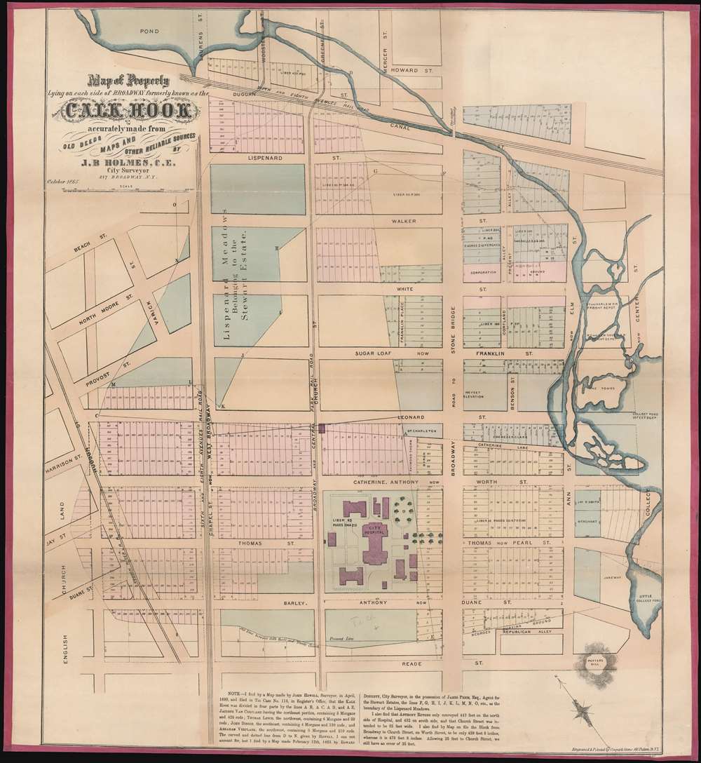
This is of John Bute Holmes's 1865 map of Tribeca, New York City. This is one of the earliest specific maps of the Tribeca area and the best all-around map of the area to the west of the Collect Pond (now the Federal Building and Collect Pond Park), showing all feeder streams and some topography. It also includes one of the earliest specific mentions of the African American Burial Ground located just south of Duane Street. In modern terms, the map covers the region from Howard and Canal Street south to Reade Street, and from Hudson Street to Federal Plaza. The city Hospital Plaza, located between Worth and Duane Street, is noted but these buildings have long since disappeared.
African American Burial Ground
This is one of the few historic maps to show the African American Burial Ground, noted here as 'Negroes Burying Ground' located between Duane and Reade Streets in Manhattan. Known today as the African Burial Ground National Monument, the excavation of this site was called the 'most important historic urban archeological project in the United States.' In the 17th and 18th centuries some 15000 African Americans were buried here, making it the largest and earliest known African American cemetery in the United States. The site was designated a National Historic Landmark in 1993 and a National Monument in 2006 by President George W. Bush.The Collect Pond
This map is significant as being one of the best depictions of the Collect Pond and its western feeder streams. The original Collect Pond extended, roughly, from modern day Franklin to Duane Street and to the east of Broadway. The pond was a natural depression with artesian springs and drainage area that filled with water seasonally. Eighteenth century engravings show picnickers enjoying the view from the nearby Potter's Hill, noted here at bottom right. In the early 19th century Fitch tested one of the first steamboats on the Collect Pond. At the time, he would have been surrounded by slaughterhouses, tanneries, gunpowder storage, bogs and prisons, not exactly a pretty place for an afternoon boat ride. Around 1811, Potter's Hill was dismantled, and the debris used fill in the Collect Pond, over which residential buildings and a major 5-way intersection were constructed. Unfortunately, the artesian springs remained active, causing the new buildings to flood and sag, transforming the area into the notorious and poverty stricken 'Five Points' district, one of the most desperate slums in American urban history.The Lotting of Manhattan
In the early 19th century most of Manhattan was undeveloped farm lands, the property of wealthy landowners with claims dating to the Dutch period of New York's history. The northern 2/3rd Manhattan was dotted with farm lands and sprawling gentlemanly estates, many with great manor houses overlooking the Hudson River. The Commissioner's Plan of 1811 and the 1807 Commission Law, laid the street grid through many of these properties and gave the city the right to claim these lands under eminent domain, providing due compensation to the landowners. While this work occurred early in lower Manhattan, central and upper Manhattan were not formally acquired by the city until the mid-19th century.What Holmes Did and Why
Holmes became fascinated by the early history of Manhattan real estate ownership, recognizing the wealth to be accrued by accurately understanding the history of city land ownership, division, and inheritance. Moreover, Holmes allied himself with the corrupt Tweed administration, assuring himself and his allies even greater wealth and political power from the eminent domain seizure of old Manhattan estates. Holmes created a series of maps, reminiscent of John Randall's 'Farm Maps', overlaid with property data, showing the borders of old estates, and notating the breakup of the lands among various heirs. The complex work of compiling the maps earned Holmes a fortune, with one newspaper suggesting on his death in 1887 that some of his individual maps were worth more than 30,000 USD. There is no complete carto-bibliography of Holmes' maps, but we believe there to be at least 50 maps, possibly more.Provenance
This map was acquired as a part of a large collection of New York cadastral maps associated with the layer Ronald K. Brown, a Deed Commissioner operating in the late 19th and early 20th century with an office at 76 Nassau Street, New York - not far from Holmes' own office. Most of the maps in the collection, including the present map, bear Brown's stamp on the verso. The maps were passed to Dominic Anthony Trotta, a real estate agent working under Brown. Brown seems to have ceased business around 1919, but Trotta continued as a real estate agent, becoming a New York Tax Commissioner in 1934 under the Fiorello H. La Guardia administration. The maps remained with Trotta's heirs until our acquisition of the collection.Publication History and Census
This map was laid out and published in October of 1865 by John Bute Holmes. It was printed and engraved by Cooper and Stone of 141 Fulton Street. Like most Holmes maps, this map is today exceedingly rare. There are four examples cited in the OCLC, among them New York Historical, Columbia University, Princeton University, and the New York State Library. We are aware of a 5th uncatalogued example at the New York Public Library.CartographerS
John Bute Holmes (March 31, 1822 - May 21, 1887) was an Irish civil engineer, city surveyor, and mapmaker based in New York City in the middle to latter 19th century. Holmes was described as a 'short, stout man, with curly gray hair, a smooth face, and a short, thick neck.' Holmes' father-in-law supplied funds for him to immigrate to America in 1840 and shortly thereafter, in 1844, he established himself in New York City. He briefly returned to Europe before once again settling in New York City in 1848. Apparently, according to several New York Times articles dating to the 1870s, Holmes was a man of dubious personal and moral character. He was involved in several legal disputes most of which were associated with his outrageous - even by modern standards - womanizing. In 1857 he was convicted of forgery of a marriage document and sentenced to 15 years of hard labor at Sing Sing, of which he served 5 before wealthy associates interceded on his behalf for an early release. Holmes seems to have been married to several different women at the same time and to have had an unfortunate attraction to exceptionally young women - one of whom, 16 year old May Chamberlayne claimed to be his wife and sued him for 50,000 USD. On another occasion he was found guilty of killing Brooklyn policeman David Gourly with whose wife he 'had been intimate.' Another woman, Miss Abrams, who he hired as a housekeeper, was repeatedly attacked by Holmes and ultimately driven to madness and was consigned to Bellevue Hospital, where she died. Although he attempted to flee the country rather than face conviction for 4th degree manslaughter, he was ultimately arrested and served one year in prison. During the American Civil War he ran for Alderman of the First Ward, in New York. Despite his legal issues, Holmes was a man of considerable means, with a personal fortune estimated between 100,000 and 500,000 USD - a significant sum in the late 19th century. Much of his wealth is associated with a series of important cadastral maps produced between 1867 and 1875 while he was employed as a surveyor and civil engineer under the corrupt Tweed regime. When Holmes died of an 'apoplectic fit' there was considerable wrangling over his estate among his 7 heirs and 11 children. The cream of his estate where his maps, some of which were valued at more than 30,000 USD in 1887. Holmes lived on a large farm-estate in Fanwood New Jersey. More by this mapmaker...
Cooper and Stone (fl. c. 1865 - 1867) was an American lithographic and engraving firm based in New York City. The firm was actively only briefly, with their earliest work dating to 1865, and their latest to 1867. They engraved an unsuccessful printing of the Declaration of Independence, a several maps for John Bute Holmes, and a map of the United States. Learn More...
Condition
Good. Relined with fresh linen and edging. Minor overall toning and reparis.
References
OCLC 55046341.