This item has been sold, but you can get on the Waitlist to be notified if another example becomes available, or purchase a digital scan.
1827 Vandermaelen Map of Thailand, Vietnam and Cambodia
CambodiaAnnam-vandermaelen-1827$450.00

Title
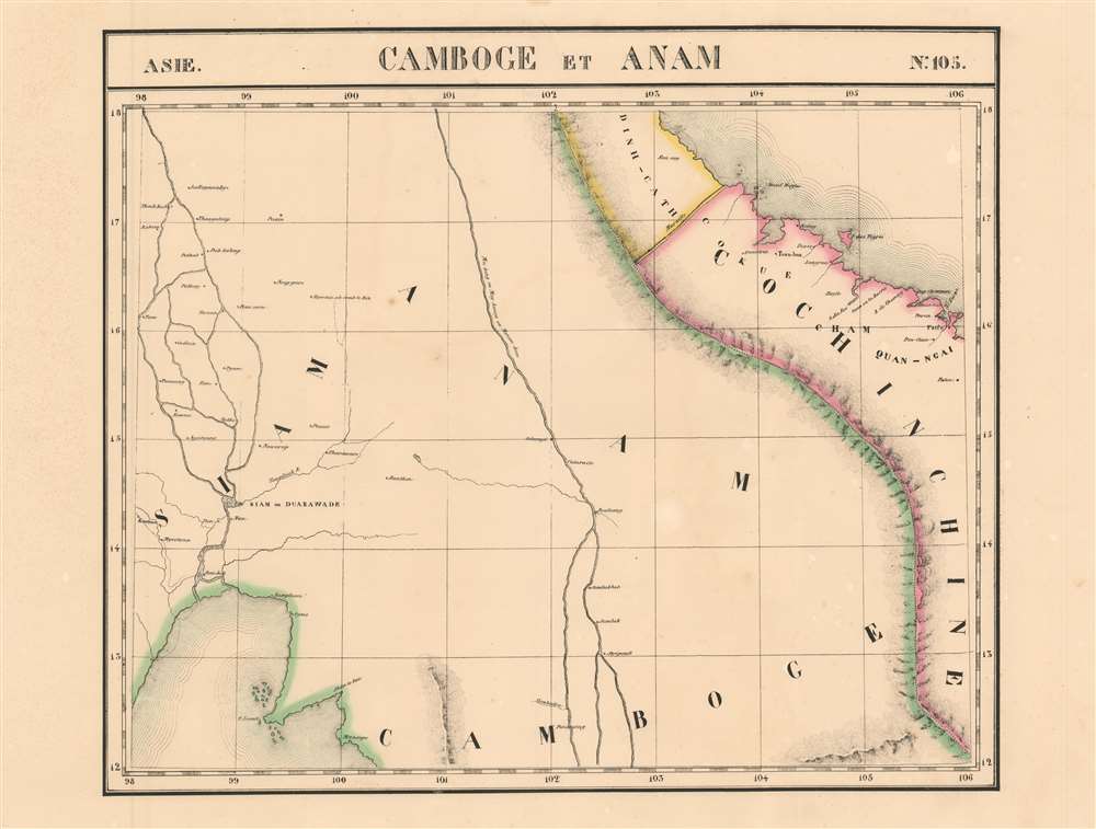
Camboge et Anam. Asie no. 105
1827 (undated) 18.5 x 22 in (46.99 x 55.88 cm) 1 : 1641836
1827 (undated) 18.5 x 22 in (46.99 x 55.88 cm) 1 : 1641836
Description
This is 1827 Vandermaelen map of Thailand, Vietnam and the Mekong River delta. It is the first large-scale atlas map of the region, and the first to be executed in lithography. Despite its title, the map embraces central Thailand as well as Cambodia and Vietnam (known as Annam in the west at that time.) As is the case with many of Vandermaelen's maps, his strict adherence to a scale of 1 : 1641836 throughout his atlas resulted in the production of very large-scale maps of regions about which the west knew little. The present map is no exception.
Thailand
The western portion of the map shows central plains of Thailand. Bankok appears at the mouth of the Chao Phraya River, but the primary focus is on the former capital city Ayyuthaya, here named 'Siam ou Duarawade'. (The term Duarawade is an interesting throwback, as the Dvaravati culture prevailed between the 7th and 10th centuries CE.) Kanchanaburi appears as 'Kanbure,' and the notation for 'Mycotzcan' is probably Nakhon Pathom. North of the capital, the meandering rivers of the Thai plains are shown with a number of named cities: Ayntaung, or Ang Thong, Sukhothai (Thoukkada) for example. 'Pezain' is probably Phitsanulok. A note further inland indicates terrain où croit le riz ('land where it is believed there is rice,') a reference to what until the 18th century was the Lanna Kingdom, or Anachak Lan Na, 'Kingdom of a Million Rice Fields.' Such precision can we hope for in the best maps!Mekong River/ Cambodia/ Laos
The map is bisected by the Mekong River. Only Vandermaelen's commitment to a uniform scale prevents this area from being shown in much smaller scale: the relative straightness of the river as shown here, and the paucity of settlements reveals deep European ignorance of this region. Phnom Penh appears in the south (Panompang on the map.) A river reaching westwards from the Mekong to a lake is probably the first printed map to show the Tonlé Sap Lake and its river. The region we know as Laos is, however, devoid of detail.Vietnam/Cochin China
The map details the central part of Vietnam, roughly from Quang Tri province to Quang Ngai. The middle of this region, roughly in the area of Quảng Nam, is marked 'Cham'; this was the geographical center of the Champa, who would not be entierly absorbed by Vietnam until 1832. A number of important cities and regions are recognizably marked: Quang Tri,(Quantrin) Thuận Hóa (Toan-hoa) Hue (Hueso) and Quảng Ngãi (Quan-Ngai) can all be found. A grossly exaggerated I.des Tigres marks the place of the tiny island of Cồn Cỏ.Long Wall of Quảng Ngãi
The map shows a wall running along the northern border of Cochin China. This is a (mis)representation of the Long Wall of Quảng Ngãi. Rather than running roughly east-west as shown here, the wall actually ran northwest-southeast, parallel to Truong Son mountain range; as Quảng Ngãi was the northernmost reach of the wall, it belongs somewhat further south than it appears here. Some scholarship suggests that the wall was built in 1819 by Lê Văn Duyệt, a high-ranking mandarin, under Emperor Gia Long, founder the Nguyễn Dynasty. However, most likely, the wall was built much earlier in the 16th century and merely adopted for border control use in the early 19th century. The original purpose of the wall was to separate the Việt and Hrê ethnicities, who, despite very active trade relations, were frequently in conflict. The wall appears in some early European maps of Southeast Asia and was known to travelers in the early 19th century, but was abandoned in 1898, after which it was overgrown and, by the early 20th century, forgotten.Publication History
This map appeared in the second part, 'Asie,' of Vandermaelen's Atlas universel de géographie physique, politique, statistique et minéralogique. The atlas was produced in one edition in 1827; only 810 complete sets were sold. The full set of six volumes appears in eleven institutional collections in OCLC; the 2nd volume alone is listed in 13.This map does not appear in any physical copies in OCLC. There was only one edition of Vandermaelen's Atlas. This map is rare on the market: we see it only once in dealers' catalogues since 1985.Cartographer
Philippe Marie Guillaume Vandermaelen (December 23, 1795 - May 29, 1869) was a Flemish cartographer active in Brussels during the first part of the 19th century. Vandermaelen is created with "one of the most remarkable developments of private enterprise in cartography," namely his remarkable six volume Atlas Universel de Geographie. Vandermaelen was born in Brussels in 1795 and trained as a globe maker. It was no doubt his training as a globe maker that led him see the need for an atlas rendered on a universal scale in order that all bodies could be understood in relation to one another. In addition to his great work Vandermaelen also produced a number of globes, lesser maps, a highly detailed 250 sheet map of Belgium, and several regional atlases. More by this mapmaker...
Source
Vandeermaelen, P. Atlas universel de geographie physique, politique, statistique et mineralogique (Bruxelles, Vandermaelen) 1827.
Atlas Universel de Geographie. This great work, featuring some 378 unique maps and compiled over three years, was the first lithograph atlas, and the first to render the world on the same projection and at a uniform scale. It was no doubt Vandermaelen’s training a globe maker that led him see the need for an atlas rendered uniformly so that all bodies could be understood in relation to one another. As a result, many newly emerging areas received more attention than prior efforts. Maps of the American West, in particular, benefited: ‘no mapmaker had previously attempted to use such a large scale for any western American area.’ (Wheat). Central and South Asia also appear in sharper focus. Despite Vandermaelen’s reliance upon existing sources, his maps very frequently provided the clearest depictions available of many poorly-understood parts of the world. The atlas was an expensive production, costing $800 in 1827. Subscription lists indicate that only 810 full sets of the atlas were sold. It was printed on high-quality paper with superior hand coloring and was engraved in a clear, legible style. Conjoined, the maps of Vendermaelen's atlas would create a massive globe some 7.75 meters in diameter, a feat which was accomplished at the Etablissement Geographique de Brussels.
Condition
Excellent condition. Few faint spots, else a bright example. Original outline hand color.
References
Rumsey 2212.137. OCLC 56138967.