
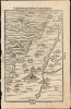
1581 / 1608 Bünting Woodcut Map of Judaea and Galilaea in the New Testament

This item has been sold.
Beschreibung des heiligen Landes Canaan.
Beautiful Woodcut of the Promised Land.
- Digital Map Information
- Suitable for large format printing
- Full resolution TIFF file
- ICC color profile embedded
- Delivered instantly via download link
Beautiful Woodcut of the Promised Land.
This is Heinrich Bünting's 1581 map of the Holy Land, providing an overview of the region from the Dead Sea to Sidon based on the place names prior to the arrival of the Israelites. Bünting's work digested Scripture and presented it to his readers as a cartographic pilgrimage, allowing them to follow the journeys of Biblical figures across an imagined geographical landscape.A Closer Look
The map presents Canaan on both sides of the Jordan River, showing the Mediterranean coast from Sidon to Gaza. Jerusalem is given the names of Salem and Jebus. Sodom and Gomorrah are shown before their destruction, and the Dead Sea is shown both unnamed and diminutive; studying this map alongside Bünting's others would imply that the expansion of the Dead Sea and the destruction of those cities were the same event. Sea monsters can be seen in the Mediterranean, although one of these may well be a duck.Bünting's Biblical Geography
Heinrich Bünting's Itinerarium Sacrae Scripturae was conceived around an innovative idea: understanding scripture through the journeys of the people who inhabited it. Rather than producing a conventional geographical atlas, Bünting organized Biblical history around movement - the travels of patriarchs, prophets, apostles, and peoples across the sacred landscape. Bünting creates a visual aid to Biblical reading, arranging places, routes, and events so that the viewer can follow the scriptural narrative geographically. This fusion of map and story helped make the Itinerarium enormously successful and one of the most distinctive works of 16th-century Biblical cartography.Publication History and Census
This woodcut first appeared in the first, Old Testament' volume of the 1581 Helmstedt edition of Heinrich Bünting's Itinerarium Sacrae Scripturae, an influential work devoted to describing and mapping journeys recorded in the Bible. Its popularity led to numerous editions and translations, and the work remained in circulation well into the following century. The identity of the formschneider, or woodblock cutter responsible for the map, remains unknown.The present example conforms typographically to the 1608 edition of the Itinerarium. Bünting's book is well represented in institutional collections in its various editions, although separately cataloged examples of this map are considerably less common. We note nine examples cataloged separately in OCLC, and the map appears occasionally on the private market.
Cartographer
Heinrich Bünting (1545 – 1606) was a Protestant pastor and theologian. He was born in Hanover, and studied theology at the University of Wittenberg. He earned his Master's degree in 1569. He remained in Wittenberg as a pastor there, before being appointed to that same position at Alt Calenberg, in the service of the Dukes of Saxony. The estate was dissolved when the marriage of the Duchess Sidona and Duke Eric the Younger foundered, and Bünting became pastor in Gronau in 1575. In Gronau, he wrote his two major works - the 1581 Itinerarium Sacrae Scripturae, and the 1584 Brunswick and Lüneburg Chronicle. He produced a smaller work on Biblical coins and measures in 1582. He would briefly serve as superintendent in Goslar, but he would be dismissed as a result of theological differences. Stung, he returned to his hometown and changed to the less controversial profession of a beer brewer, until his death in 1606. The work for which he is best known, Itinerarium Sacrae Scripturae, was the first complete summary of biblical geography. It remained in print in more than sixty editions, long after his death. Earlier editions contain some of the most distinctive and sought after maps, most notably his map of the world in the shape of a cloverleaf, and an allegorical map of Asia in the form of a Pegasus. Further Details...
Source
Bünting, Heinrich, Itinerarium Sacrae Scripturae, (Magdeburg: Kirchner) 1608.
Condition
Very good.
References
OCLC 634420059. Laor, E. Mapping of the Holy Land 140.