This item has been sold, but you can get on the Waitlist to be notified if another example becomes available, or purchase a digital scan.
1809 Arrowsmith Map of Canada and United States (British Possessions)
Canada-arrowsmith-1809$75.00

Title
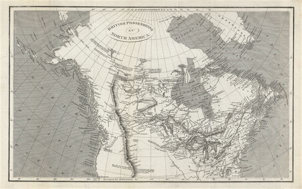
British Possessions in North America.
1809 (undated) 10 x 16 in (25.4 x 40.64 cm)
1809 (undated) 10 x 16 in (25.4 x 40.64 cm)
Description
This is a fine example of the 1809 A. Arrowsmith map of the British possessions in North America, or Canada. Covers Canada, Alaska, and part of the United States from the Baffin Bay south as far as San Francisco - then an insignificant Spanish fortification. Along the way, many Indian settlements and routes are marked. The Rocky Mountains, here identified as the 'Stony Mountains,' are primitively depicted as a single mountain range, and they 'divide into several low ridges' toward the south. Several notes, including one marking the trail along the Columbia River from Mt. Hood in Vancouver to Howes Sound Lake mentions that 'the Indians say they sleep 8 Nights in descending this River to the Sea.' Drawing form indigenous reports, Arrowsmith also textually identifies Great Salt Lake, here referred to as 'Pearl Shell Lake.' In the far north the Arctic Sea, seen by Mackenzie and Hearne (1781 & 1771 respectively) - likely the Dolphin and Union Straits – are duly noted. Greenland is also attached to the mainland, as was common in maps of the period. Throughout, the map identifies various cities, towns, rivers and assortment of additional topographical details. This map was created by Aaron Arrowsmith for the 1809 issue of his General Atlas.
Cartographer
Aaron Arrowsmith (1750-1823), John Arrowsmith (1790-1873), and Samuel Arrowsmith. The Arrowsmith family were noted map engravers, publishers, geographers, and cartographers active in the late 18th and early 19th century. The Arrowsmith firm was founded by Aaron Arrowsmith, who was trained in surveying and engraving under John Cary and William Faden. Arrowsmith founded the Arrowsmith firm as a side business while employed by Cary. The firm specialized in large format individual issue maps containing the most up to date and sophisticated information available. Arrowsmith's work drew the attention of the Prince of Wales who, in 1810, named him Hydrographer to the Prince of Wales, and subsequently, in 1820, Hydrographer to the King. Aaron Arrowsmith was succeeded by two sons, Aaron and Samuel, who followed him in the map publication business. The Arrowsmith firm eventually fell to John Arrowsmith (1790-1873), nephew of the elder Aaron. John was a founding member of the Royal Geographical Society. The firm is best known for their phenomenal large format mappings of North America. Mount Arrowsmith, situated east of Port Alberni on Vancouver Island, British Columbia, is named for Aaron Arrowsmith and his nephew John Arrowsmith. More by this mapmaker...
Source
Arrowsmith, A., General Atlas, (London) 1809.
Condition
Very good. Original fold lines visible. Typical wear along folds.