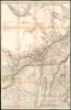
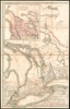
1831 Bouchette / Wyld Map of Canada (Quebec / Ontario)
Canada-bouchette-1831$19,500.00
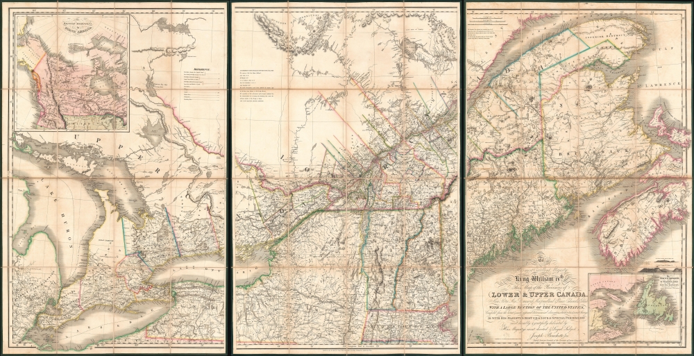

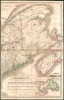

Title
To His Most Excellent Majesty King William IVth This Map of the Provinces of Lower and Upper Canada, Nova Scotia, New Brunswick, Newfoundland and Prince Edwards Island, with a Large Section of the United States...
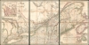
1831 (dated) 40 x 78 in (101.6 x 198.12 cm) 1 : 887040
1831 (dated) 40 x 78 in (101.6 x 198.12 cm) 1 : 887040
Description
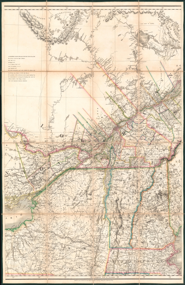
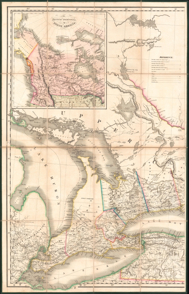
This is Joseph-Francis Bouchette's rare large-scale 1831 map of Canada - a seminal map relating to Canadian development, immigration, and land usage. The map details the provinces of Upper and Lower Canada (Ontario and Quebec), which were established in 1791. Most significantly, the map focuses on lands, towns, roads, and districts designated to the Canada Company - the most important immigration and settlement initiative in Canadian history. The Canada Company’s copious settlements are indicated on the map by an asterisk or a cross next to each name. Bouchette notes land disputes between the United States and British North America in Maine and Oregon, but predictably advocates exclusively for British positions.
This map is rare. We note examples in approximately five Canadian academic and governmental collections, but few outside of Canada - where most catalog entries are digital-only entities. There appears to be an example at Yale, Stanford, and the Bibliothèque Nationale de France. We note just three examples publicly offered in the last thirty years.
The Canada Company
The map argues strongly for the Bouchette family's political and financial interests. Following the British defeat in the American Revolutionary War, the crown began a campaign to more aggressively settle Canadian provinces with British loyalists. Both military and civilian colonists were given rights to petition the Governor for free or leased lands. The Canada Company was formed by Royal Charter in August 1826 to assist in this process. The joint-stock company initially acquired Upper Canada's undeveloped clergy and crown reserves, as well as lands acquired from the Chippewa First Nation on the eastern shores of Lake Huron - the Huron Reserve. In aggregate they controlled over 2,400,000 acres of undeveloped real estate.Flawed but Successful
Like many British joint-stock companies of the period, the Canada Company, from its earliest days, was mired in mismanagement and corruption. That said, unlike many similar companies, the Canada Company achieved its goals, providing colonists with good ships, low fares, implements and tools, and quality inexpensive land. The Company established hundreds of towns throughout their vast lands, many identified here, developing basic services in each. Over the next 100 years, the company sold off the lands, and by 1938 only about 20,000 acres remained. In 1951, these were taken over by the government, some to be sold, others turned into Pinery Provincial Park.Political and Financial Agenda
The Bouchettes were almost certainly investors in the Canada Company and aggressively promoted its goals. Bouchette Sr. wrote a chapter long defense of the Canada Company in his British Dominions. When company infighting, mismanagement, extreme loyalist policies, and slavish devotion to Tory elites led to the 1837 Upper Canada Rebellion, the mapmaker's younger brother Robert Shore Milnes Bouchette (1805 - 1879) played a major role, for which he was exiled to Bermuda (oh the horror!).Frequent Misattribution
This map is frequently attributed to Joseph Bouchette Sr. (1774 - 1841), but it is in fact the work of Joseph-Francis Bouchette, the former's son. In his 1831 book, British Dominions in North America: Or, A Topographical and Statistical Description of the Provinces of Lower and Upper Canada..., the author's father, Joseph Bouchette Sr., properly attributes the map:The geographical map of the British provinces, and of a section of the adjacent states of the American union, accompanying the work, will, it is hoped, be found an interesting adjunct, from the scope of the country it embraces, as well as an account of the sources of information whence it was compiled. This map was constructed by the author’s eldest son, Joseph Bouchette, Esq., Deputy Surveyor-General of Lower Canada, and must, like the other maps, be left in a great measure to speak for itself. It is but justice to the compiler, however, to mention the extreme laboriousness with which, during three years, he attached himself to its construction, in the midst of active professional duties-the close investigation as to the correctness of documents that preceded their application, and the science with which he was capable of graphically applying the information these documents contained. To this gentleman the author is also indebted for his scientific aid in the compilation of several parts of the topographical maps.
Publication History and Census
This map was compiled by Joseph-Francis Bouchette, engraved by James and Charles Walker (J. and C. Walker), and published by James Wyld. According to the mapmaker's father as above, Joseph Bouchette Sr., the map was intended as an accompaniment to his own work on Canada, British Dominions in North America. Curiously, although this book is reasonably common, the map is exceedingly rare, and we are further aware of no situation where they are presented concurrently. Likely the lavish production quality of the map itself led naturally to low production runs, and so disseminating it with the book would have been impractical. The present example represents the first edition. We note subsequent editions with updates in 1852 and 1853. The map follows in the cartographic lineage of the elder Bouchette's smaller map of 1815.This map is rare. We note examples in approximately five Canadian academic and governmental collections, but few outside of Canada - where most catalog entries are digital-only entities. There appears to be an example at Yale, Stanford, and the Bibliothèque Nationale de France. We note just three examples publicly offered in the last thirty years.
CartographerS
Joseph-Francis Bouchette (July 27, 1800 - 1881) was a British-Canadian surveyor and mapmaker active in Ontario from the mid to late 19th century. Bouchette was born in Montréal, Quebec. His father, also Joseph Bouchette (1774 - 1841) held the position Surveyor General of Lower Canada. From 1829, when his father left Canada for a European tour, J. F. Bouchette took over official survey duties under the title Deputy Surveyor-General. His issued his most important map, a gigantic map of Quebec, Ontario, and the Maritimes, and a major update on his father's comparable map of 1815, in 1831. In 1840, the Surveyor-General Office was abolished, but in 1851 Bouchette was appointed Senior Surveyor to the Crowns Lands Department. In 1826, he married Margery Elspie Fraser (1806-1854), the eldest daughter of Simon Fraser (c.1760 - 1839), Seigneur de Sainte-Anne-de-Bellevue. In addition to his 1831 map, he published an atlas of Canada and a view of Montreal. Joseph died at Pont-Rouge, Quebec. More by this mapmaker...
Wyld (1823 - 1893) was a British publishing firm active throughout the 19th century. It was operated by James Wyld I (1790 - 1836) and his son James Wyld II (November 20, 1812 - 1887) were the principles of an English mapmaking dynasty active in London during much of the 19th century. The elder Wyld was a map publisher under William Faden (1749 - 1836) and did considerable work on the Ordinance Survey. On Faden's retirement in 1823, Wyld took over Faden's workshop, acquiring many of his plates. Wyld's work can often be distinguished from his son's maps through his imprint, which he signed as 'Successor to Faden'. Following in his father's footsteps, the younger Wyld joined the Royal Geographical Society in 1830 at the tender age of 18. When his father died in 1836, James Wyld II was prepared to fully take over and expand his father's considerable cartographic enterprise. Like his father and Faden, Wyld II held the title of official Geographer to the Crown, in this case, Queen Victoria. In 1852, he moved operations from William Faden's old office at Charing Cross East (1837 - 1852) to a new, larger space at 475 Strand. Wyld II also chose to remove Faden's name from all of his updated map plates. Wyld II continued to update and republish both his father's work and the work of William Faden well into the late 1880s. One of Wyld's most eccentric and notable achievements is his 1851 construction of a globe 19 meters (60 feet) in diameter in the heart of Leicester Square, London. In the 1840s, Wyld also embarked upon a political career, being elected to parliament in 1847 and again in 1857. He died in 1887 following a prolific and distinguished career. After Wyld II's death, the family business was briefly taken over by James John Cooper Wyld (1844 - 1907), his son, who ran it from 1887 to 1893 before selling the business to Edward Stanford. All three Wylds are notable for producing, in addition to their atlas maps, short-run maps expounding upon important historical events - illustrating history as it was happening - among them are maps related to the California Gold Rush, the New South Wales Gold Rush, the Scramble for Africa, the Oregon Question, and more. Learn More...
John Walker (1787 - April 19, 1873) was a British map seller, engraver, lithographer, hydrographer, geographer, draughtsman, and publisher active in London during the 19th century. Walker published both nautical charts and geographical maps. His nautical work is particularly distinguished as he was an official hydrographer for the British East India Company, a position, incidentally, also held by his father of the same name. Walker's maps, mostly published after 1827, were primarily produced with his brothers Charles Walker and Alexander Walker under the imprint J. and C. Walker. Among their joint projects are more than 200 maps for the influential Society for the Diffusion of Useful Knowledge Atlas (SDUK). In addition they published numerous charts for James Horsburgh and the British Admiralty Hydrographic Office, including Belcher's important map of Hong Kong and Carless' exploratory map of Karachi. The J. and C. Walker firm continued to publish after both Walkers died in the 1870s. Learn More...
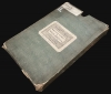
Condition
Very good. Dissected on linen. 3 sections, as issued. Original slipcase. Former library stamps embossed onto map. Deaccessioned.
References
OCLC 61562458. Rumsey, 4436.000. Thomson, D. W., Men and Meridians: The History of Surveying and Mapping in Canada, pp. 264-269. Winearls, J., Mapping Upper Canada 1780 - 1867, #85.