This item has been sold, but you can get on the Waitlist to be notified if another example becomes available, or purchase a digital scan.
1784 James Cook Nautical Map of Southwest Newfoundland, Canada
Canada-cook-1784$175.00

Title
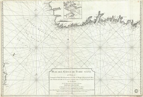
Plan des Cotes de Terre Neuve IIIe. Feuille Contenant la Partie Meridionale depuis les Iles de Bergeo jusqu au Cap de Raye, avec l'Entrée du Golfe de St. Laurent comprise entre ce Cap et le Cap de Nord de l'Ile Royale.
1784 (dated) 25.5 x 37 in (64.77 x 93.98 cm) 1 : 339000
1784 (dated) 25.5 x 37 in (64.77 x 93.98 cm) 1 : 339000
Description
A scarce 1794 map of the southwest coast of Newfoundland, Canada, issued by the Depot de la Marine and surveyed by Captain Cook. This map, the third in this series, covers from Cape Anguille on the Gulf of St. Lawrence, southwards to Channel-Port aux Basques, then east past La Poile Bay, as far as Burego. To the south, just appearing at the bottom left corner of the map, is the nearby northeast coast of Cape Breton. The coast is dotted with soundings and the seas full of rhumb lines. This map was surveyed by Captain Cook and it is in these surveys that he mastered the nautical surveying skills that would prove so effective on his subsequent three great voyages of discovery. It was published by the French Depot General da la Marine.
CartographerS
Captain James Cook (7 November 1728 - 14 February 1779) is a seminal figure in the history of cartography for which we can offer only a cursory treatment here. Cook began sailing as a teenager in the British Merchant Navy before joining the Royal Navy in 1755. He was posted in America for a time where he worked Samuel Holland, William Bligh, and others in the mapping of the St. Lawrence River and Newfoundland. In 1766 Cook was commissioned to explore the Pacific and given a Captaincy with command of the Endeavour. What followed were three historic voyages of discovery, the highlights of which include the first European contact with eastern Australia, the discovery of the Hawaiian Islands (among many other Polynesian groups), the first circumnavigation of New Zealand, some of the first sightings of Antarctica, the first accurate mapping of the Pacific Northwest, and ultimately his own untimely death at the hands of angry Hawaiians in 1779. The influence of Cook work on the mapping and exploration of the Pacific cannot be understated. More by this mapmaker...
Dépôt des Cartes et Plans de la Marine (fl. 1720 - present), often called the Dépôt de Marine, was a French hydrographic mapping organization founded in 1720 under Charles-Hercule of Albert de Luynes (1674 - 1734). Much like the U.S. Coast Survey, the British Admiralty, and the Spanish Deposito Hydrografico, the Dépôt was initiated as a storehouse and distribution center of existing nautical and marine charts. Eventually the Dépôt initiated its own mapping activities in an attempt to improve and expand upon existing material. Some of the more prominent cartographers and hydrographers associated with the of Dépôt des Cartes were, Philippe Buache, Jacques-Nicholas Bellin, Giovanni Rizzi-Zannoni, Rigobert Bonne, and Jean Nicolas Buache. Learn More...
Condition
Very good. Minor wear along original centerfold. Unusual older fill repair at two places on verso.