This item has been sold, but you can get on the Waitlist to be notified if another example becomes available, or purchase a digital scan.
1818 Pinkerton Map of British North America or Canada
Canada-pinkerton-1818$150.00

Title
British Possessions in North America.
1818 (undated) 20 x 27.5 in (50.8 x 69.85 cm)
1818 (undated) 20 x 27.5 in (50.8 x 69.85 cm)
Description
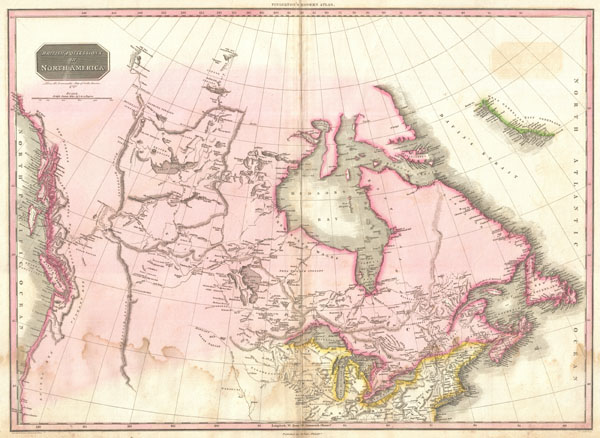
Pinkerton's extraordinary 1818 map of the British Possessions in North America. Based on Arrowsmith's historic map of North America, this map covers the continent north of the 40th degree of latitude, including all of the territory currently claimed by Canada.
This fascinating map follows roughly 100 years of vigorous exploration of this region by adventurers in search of a navigable river and lake route from the Great Lakes to the Pacific. And yet, even after all of this exploration, much of the territory remains vague and uncertain. Details numerous river systems and lakes, some real, some fictional, between the Hudson Bay and the Rocky Mountains. Offers copious notations throughout, such as 'great quantities of coal in this creek' and 'Knistineaux war route.' Shows the Missouri River as far as the Mandan settlements where Lewis and Clark wintered. Though the official narrative of Lewis and Clark's historic journey had not been published when this map was in production, it is possible that Pinkerton had access to some preliminary accounts. Names several sightings of the Arctic Sea, far to the north, by the explorers Mackenzie and Hearne in the 18th century. The west coast, including Vancouver Islands, is particularly well mapped. Also notes numerous American Indian nations including the Knisteneaux (Cree), Blood, Cattanahowes, Snake, Assinpolls, Snake, Atnah, etc.
Drawn by L. Herbert and engraved by Samuel Neele under the direction of John Pinkerton. This map comes from the scarce American edition of Pinkerton's Modern Atlas, published by Thomas Dobson & Co. of Philadelphia in 1818.
CartographerS
John Pinkerton (February 17, 1758 - March 10, 1826) was an Scottish writer, historian, and cartographer. Pinkerton was born in Edinburgh, Scotland. He was a studious youth with a passion for the classics. As a young man, he studied at Edinburgh University before apprenticing as a lawyer. Around this time, he began writing, with his first book, Elegy on Craigmillar Castle published in 1776. Pinkerton moved to London in 1781 to pursue his writing career in earnest. He successfully published several works of literature, poetry, and history. Pinkerton proved passionate in his literary and historical writings, but his correspondence with other cartographers has been labeled as aggressive, even insane. In addition to his work as a writer and historian, Pinkerton was one of the leading masters of the Edinburgh school of cartography which flourished from roughly 1800 to 1830. Pinkerton and his contemporaries (Thomson and Cary) redefined European cartography by abandoning typical 18th century decorative elements such as elaborate title cartouches and fantastical beasts in favor of detail and accuracy. Pinkerton's principle work is Pinkerton's Modern Atlas published from 1808 through 1815 with a special American reissue by Dobson and Co. in 1818. Pinkerton relocated to Paris in 1818, where he managed his publishing business until his death in 1826. More by this mapmaker...
Thomas Dobson (1751 - 1823) was an American publisher active in Philadelphia during the late 18th and early 19th centuries. Dobson was born in Edinburgh, Scotland in 1751 and emigrated to Philadelphia c. 1780. In Philadelphia, he established a successful printing business by republishing edited and updated versions of important British reference materials in matching quality but at a much lower price point. He is best known for publishing the first American edition of the Encyclopedia Britannica. He also published America's first Hebrew Bible. Cartographically Dobson's most notable work is 1818 republication of Pinkerton's fantastic Modern Atlas. Learn More...
Source
Pinkerton, J., A Modern Atlas, from the Lates and Best Authorities, Exhibiting the Various Divisions of the World with its chief Empires, Kingdoms, and States; in Sixty Maps, carefully reduced from the Larges and Most Authentic Sources. 1818, Philadelphia, Thomas Dobson Edition.
Condition
Good condition. Mild to moderate damp staining in lower quadrants Original centerfold. Blank on verso.
References
Rumsey 0732.046. Phillips (America), p. 195. Phillips (Atlases) 724. National Maritime Museum, 409.