1831 Teesdale Map of Canada and the Great Lakes
Canada-teesdale-1831$200.00

Title
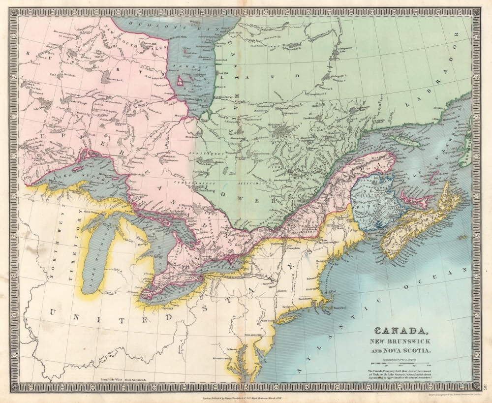
Canada, New Brunswick and Nova Scotia.
1831 (dated) 13.75 x 16.5 in (34.925 x 41.91 cm) 1 : 6500000
1831 (dated) 13.75 x 16.5 in (34.925 x 41.91 cm) 1 : 6500000
Description
This is an 1831 Henry Teesdale and John Dower map of Canada and the Great Lakes.
A Closer Look
Depicting from Hudson Bay south to the central United States and from just west of Lake Superior to the Atlantic Ocean, Upper Canada, Lower Canada, Quebec, New Brunswick, Labrador, Nova Scotia, Cape Breton Island, and Prince Edward Island appear. Cities, towns, and villages are labeled along the St. Lawrence River and in eastern Canada, but farther west very little settlement is indicated. Montreal and Quebec are prominently labeled. The Great Lakes are illustrated, with islands, harbors, gulfs, and other features identified. Very little detail appears in the United States - as it is not the focus of this map - though a handful of cities are labeled, including Washington, D.C., New York, Philadelphia, Niagara, Boston, Providence, and Portland. The New York Grand Canal appears in bold, with proposed branch canals illustrated.Publication History and Census
This map was drawn and engraved by John Crane Dower and published by Henry Teesdale in 1831 in his A New General Atlas of the World. We note six examples of the separate map cataloged in OCLC: Brock University, the Bibliothèque et Archives nationales du Québec, the Université Laval, Michigan State University, the University of Oxford, and the National Library of Australia.CartographerS
Henry Teesdale (December 1776 - January 1856) was a British map publisher active in the first half of the 19th century. Teesdale was born in London. He was elected to the Royal Geographical Society in 1830. Teesdale initially partnered with John Hordan and William Colling Hobson as Henry Teesdale and Company, but this partnership was dissolved in 1832. Afterwards Teesdale continued to publish maps and atlases on his own account. He worked with several major British map engravers of the period including John Crane Dower, Christopher Greenwood, and Josiah Henshall, among others. His most prominent work is a large map of the world engraved by Dower. He must have enjoyed considerable commercial success because in 1845 he is registered as a partner in the Royal Bank of Scotland. Teesdale died in January of 1856 and was buried in All Souls, Kensal Green. More by this mapmaker...
John Crane Dower (1791 - February 20, 1847) was an English engraver, map publisher, and printer active in northern London during the first half of the 19th century. Dower had his office at 6 Cumming Place, Pentonville, London. He was most active as an engraver from 1820 to 1847, where he produced work for John Greenwood, William Fowler, Henry Teesdale, Thomas Moule, Geroge Bradshaw, and others. Dower passed his business on two his two sons, John James Downer, and Fredreric Jamesd Dower. Learn More...
Source
Teesdale, H., A New General Atlas of the World..., (London: Teesdale) 1831.
Condition
Very good. Light wear and toning along original centerfold.
References
OCLC 43220785.