This item has been sold, but you can get on the Waitlist to be notified if another example becomes available, or purchase a digital scan.
1778 Robert de Vaugondy Map of Canada, New Foundland, Nova Scotia, and the Great Lakes
CanadaGreatLakes-vaugondy-1778$400.00

Title
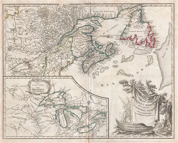
Partie De L'Amerique Septent. Qui Comprend La Nouvelle France ou Le Canada.
1778 (undated) 19.5 x 24 in (49.53 x 60.96 cm) 1 : 4000000
1778 (undated) 19.5 x 24 in (49.53 x 60.96 cm) 1 : 4000000
Description
A fine example of Robert de Vaugondy's 1778 map of former French dominions in Canada and in the vicinity of the Great Lakes at the outset of the American Revolutionary War. Essentially two maps on a single sheet. The primary map covers the Gulf of St. Lawrence, St. Lawrence River, and surrounding territories including Newfoundland and Nova Scotia, as well as parts of Quebec, Ontario, New York, Maine, New Hampshire, and Vermont. The secondary map, dominated the lower left quadrant, detailed the Great Lakes, or as the map defines them 'Les Lacs du Canada.' Although initially issued in 1755, the present map is an updated edition dating to 1778 which has been re-engraved to reflect the outcome of the French and Indian War. The secondary map roughly follows the 1744 map of French cartographer Nicolas Bellin in detailing the Great Lakes and surrounding territories; however, it does extend significantly westward into the lands of the Sioux and the rivers surrounding the Lake of the Woods - no doubt a response to additional French information gleaned from fur traders in the region. Vaugondy's influence on French cartography was significant and this became the standard template for the mapping of this region for roughly 50 years from its original publication. The present example is the 4th state of this map, the last to be issued directly by the Vaugondy Family before the map plates were passed on to Charles Delamarche.
The French and Indian War dramatically transformed political and colonial relationships in the New World. According to the 1763 treaty of Paris, which officially ended the war, France ceded most of its North American Territories to Great Britain. Most of the changes and updates to this map follow the Treaty of Paris and subsequent treaties, such as the 1868 Treaty of Fort. Stanwix. While the French name Acadia is still applied to modern day Nova Scotia, 'Nouvelle Ecosse' has also been added. The boundaries defining the territories of the Hudson Bay Company and the Indian territories south of Lake Ontario are also notable.
The large inset map in the lower left quadrant, featuring its own rococo cartouche, follows primarily the 1744 mapping of Nicholas Bellin and Pierre Francois Xavier de Charlevoix. The map, however, extends much further west presenting knowledge of inland river systems as far as the Lac of the Woods - no doubt reflecting the exploration of pre-French and Indian War French fur traders like Pierre Gaultier de la Verendrye. There are several additional significant updates over the Bellin/Charlevoix plan, including corrections to both form and alignment of Lake Erie and Lake Ontario. Chicago, written 'Chicagou' is noted on the southern shores of Lake Michigan.
Of particular note are the four spurious islands in Lake Superior, here identified as Philippeaux, Pontchartrain, Maurepas, and St. Anne. The islands were intended to honor Charlevoix' s personal patron, the Count of Maurepas, Jean-Frederic Phelypeaux. The largest of the three islands, Philippeaux, is named directly after the count. The second largest island, Pontchartrain, refers to Phelypeaux's family estate. The third island, which may in fact be a mismapping of the factual State Islands, is named after the count's seat, Maurepas. The fourth and smallest of the islands, St. Anne, references the count's patron saint. Charlevoix described the islands as being rich in minerals leading numerous explorers to search for them in vain. Bellin dutifully introduced the four islands to his map, and such was his influence that they were subsequently copied by most subsequent cartographers, including John Mitchell in his seminal 1755 wall map of North America. The highly regarded Mitchell map was used in negotiating the 1783 Treaty of Paris that formally concluded the American Revolutionary War. Therein, the apocryphal Philippeaux was assigned as a marker for the new United States - British America border thus setting the stage, as one might image, for later political strife.
This map was originally engraved by Catherine Haussard, one of the few female engravers active in Paris during the 18th century. Her fine work extends to the large and elaborate decorative title cartouche in the lower right quadrant. The cartouche attempts to illustrate some of the flora and fauna common to the Americas, including a stylized but recognizable beaver, one of the primary exports of the region, in the lower right corner. A distance scale set in a typical Newfoundland dory offers scale both in miles and nautical leagues. In this edition the 'C. Haussard sculp.' imprint has been replaced by that of Groux, the engraver responsible for the map's 1778 update.
Curiously the year of this map's issue, 1778, also marks the return of the French to North America as allies to the colonial forces in the American Revolutionary War. Some have suggested that the ultimate victory of the fledgling United States was France's revenge for having lost its own New World territories in the Treaty of Paris.
Cartographer
Robert de Vaugondy (fl. c. 1716 - 1786) was French may publishing from run by brothers Gilles (1688 - 1766) and Didier (c. 1723 - 1786) Robert de Vaugondy. They were map publishers, engravers, and cartographers active in Paris during the mid-18th century. The father and son team were the inheritors to the important Nicolas Sanson (1600 - 1667) cartographic firm whose stock supplied much of their initial material. Graduating from Sanson's maps, Gilles, and more particularly Didier, began to produce their own substantial corpus. The Vaugondys were well-respected for the detail and accuracy of their maps, for which they capitalized on the resources of 18th-century Paris to compile the most accurate and fantasy-free maps possible. The Vaugondys compiled each map based on their own geographic knowledge, scholarly research, journals of contemporary explorers and missionaries, and direct astronomical observation. Moreover, unlike many cartographers of this period, they took pains to reference their sources. Nevertheless, even in 18th-century Paris, geographical knowledge was limited - especially regarding those unexplored portions of the world, including the poles, the Pacific Northwest of America, and the interiors of Africa, Australia, and South America. In these areas, the Vaugondys, like their rivals De L'Isle and Buache, must be considered speculative or positivist geographers. Speculative geography was a genre of mapmaking that evolved in Europe, particularly Paris, in the middle to late 18th century. Cartographers in this genre would fill in unknown lands with theories based on their knowledge of cartography, personal geographical theories, and often dubious primary source material gathered by explorers. This approach, which attempted to use the known to validate the unknown, naturally engendered rivalries. Vaugondy's feuds with other cartographers, most specifically Phillipe Buache, resulted in numerous conflicting papers presented before the Academie des Sciences, of which both were members. The era of speculative cartography effectively ended with the late 18th-century explorations of Captain Cook, Jean Francois de Galaup de La Perouse, and George Vancouver. After Didier died, his maps were acquired by Jean-Baptiste Fortin, who in 1787 sold them to Charles-François Delamarche (1740 - 1817). While Delamarche prospered from the Vaugondy maps, he defrauded Vaugondy's window Marie Louise Rosalie Dangy of her rightful inheritance and may even have killed her. More by this mapmaker...
Source
Robert de Vaugondy, G., Atlas Universel, (Paris: Antoine Boudet) 1778.
The Atlas Universel was the crowning glory of the Robert de Vaugondy firm's atlas production. The atlas was revolutionary on many levels and exemplified the Vaugondy credo commode, complet, univorme, et suive (convenient, complete, uniform, and easy to use). The atlas thus consisted of a wide corpus of maps, both modern and historical, was of moderate height and width, and featured maps of uniform style and structure. They partnered with Antoine Boudet, a shrewd businessman and publisher with whom they had worked previously, to produce the 1752 first edition. To minimize his fiscal risk, Boudet sold the atlas first by subscription using a large prospectus, receiving in the process over 1100 pre-orders. The first edition appeared in 1752 and contained beautifully produced maps with elaborate freshly designed allegorical cartouche work, generally by Pierre-Edme Babel, Pierre Philippe Choffard, and Charles Nicholas Cochin. Most of the maps were engraved by the Delahaye firm, the payment for whose services ultimately led to legal disputes. Despite proving a popular work of astounding quality, the Atlas Universal received harsh criticism from fellow cartographers, particularly Philipppe Buache. Ever at odds with the Vaugondys, Buache's critical perspective may have been influenced more by political maneuvering than academic affront. The atlas was issued in multiple editions between 1752 and 1788. Later editions, issued after 1786, were taken over by Charles Delamarche, who inherited the Robert de Vaugondy firm and assumed Boudet's publication rights.
Condition
Very good. Some foxing.
References
Rumsey 3353.099 (1755). Kershaw, K. A., Early Printed Maps of Canada, no. #356. Pedley, M. A., Bel et Utile: The Work of the Robert de Vaugondy Family of Mapmakers, #459-4. Sellers, John R. and Van Ee, Patricia, Maps and Charts of North America, no. #61.