
1939 Bureau of Statistics Pictorial Map of Southern Canada and Northern U.S.


This item has been sold.
Animated Tourist Map of the Southern Portion of Canada And Highway Connections with the United States...
Canada-U.S. Relations at the Start of World War II.
Choose a Collection:
- Digital Map Information
- Suitable for large format printing
- Full resolution TIFF file
- ICC color profile embedded
- Delivered instantly via download link
This Item
Enquire
Canada-U.S. Relations at the Start of World War II.
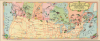
This is a charming 1939 pictorial map of southern Canada and the northern U.S. prepared by the Canadian Bureau of Statistics. The map appeared in the promotional book Canada 1939, which was issued to coincide with the 1939-40 World's Fair held in New York City.A Closer Look
The map covers the southern Canadian provinces and northern U.S. states, with the provinces color-shaded. Although not labeled on the recto, Canada's national parks are outlined and listed in a key map on the verso. Illustrations appear throughout, highlighting the wildlife, scenery, recreation, and economic products of each province. Additional illustrations display ships off the coasts. The map emphasizes road and highway connections between the U.S. and Canada and the importance of automobiles for cross-border travel (not tracing rail lines, which tended to be intranational, though a line to Churchill on Hudson Bay is illustrated). Aside from national parks, the verso key map notes the points of entry between the U.S. and Canada, with the number of automobiles entering through each in 1937.Canada at the 1939-40 World's Fair
This map was prepared to coincide with Canada's participation in the 1939-40 New York World's Fair, which was a strategic exercise in soft power and economic branding, occurring at a pivotal moment as the nation transitioned from the Great Depression into the Second World War. Located within the British Colonial section, the Canadian Pavilion was designed in a sleek, Art Deco-inspired style that aimed to project an image of a modern, industrializing nation rather than just a rugged frontier. Consequently, the exhibits heavily emphasized Canada's growing manufacturing sector in addition to its vast natural resources and scenic beauty.The fair's second year, however, saw a dramatic shift in tone and purpose. By the time the 1940 season opened, Canada was officially at war with Nazi Germany, whereas the United States remained neutral. Consequently, the pavilion was repurposed as a tool for wartime diplomacy and recruitment. Exhibits were updated to emphasize Canada's role as a vital supplier for the war effort and a loyal member of the British Commonwealth. It served as a subtle but persistent reminder to the American public of the shared democratic values and the looming threat in Europe, and arguably helped lay the groundwork for the deep defense and economic partnerships between the two countries that would define the post-war era.
Publication History and Census
This map was published by the Dominion Bureau of Statistics in Ottawa and published in the book Canada 1939 (New York World's Fair Edition) The Official Handbook of Present Conditions and Recent Progress. The map is not independently cataloged at any institution, while the entire book (OCLC 38882750) is held by 19 institutions.Condition
Very good. Light wear along original fold lines.