This item has been sold, but you can get on the Waitlist to be notified if another example becomes available, or purchase a digital scan.
1926 Poole Brothers Map of Canada and the Canadian Pacific Railway
CanadianPacificRy-poolebros-1926$150.00


Title
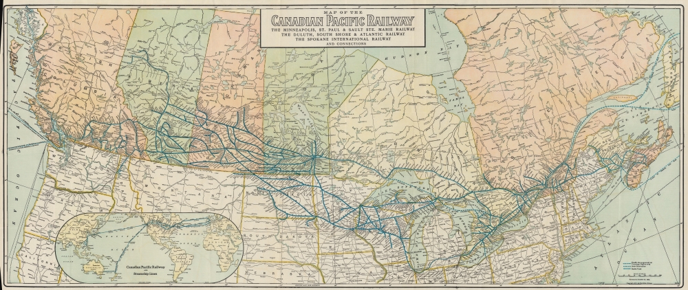
Map of the Canadian Pacific Railway The Minneapolis, St. Paul and Sault Ste. Marie Railway The Duluth, South Shore and Atlantic Railway The Spokane International Railway and Connections.
1926 (dated) 18.5 x 44 in (46.99 x 111.76 cm) 1 : 4608000
1926 (dated) 18.5 x 44 in (46.99 x 111.76 cm) 1 : 4608000
Description
Travel across Canada in style at the height of the Roaring Twenties with this 1926 Poole Brothers and Canadian Pacific Railway map. Using eye-catching blue ink, the map highlights the Canadian Pacific Railway's extensive rail network and its connections into the United States.
A Closer Look
The Canadian Pacific Railway stretches across the amp with connections into the United States through North Dakota, Minnesota, and Wisconsin. Trackage rights have been negotiated along the Michigan Central's route, connecting the Canadian Pacific with Detroit and Chicago from the east. Steamship routes to Honolulu, Auckland, Sydney, and Yokohama are marked from Vancouver, as are routes from Quebec and St. John, New Brunswick to Liverpool. An inset in the lower left depicts worldwide steamship routes with distances.The Canadian Pacific Railway
The Canadian Pacific Railroad was first proposed under Canadian Prime Minister John A. Macdonald and businessman Sir Alexander Tilloch Galt. The proposed route was to extend westward from established Ontario and Quebec railroad networks to the Pacific. The challenges were political, economic, and logistic. A fully Canadian route would require crossing 1,600 km (990 mi) of rugged and barren Canadian Shield, the muskeg of Northern Ontario, through unfriendly Blackfoot American Indian Lands, and across the Selkirk Mountains of British Columbia. The government offered huge incentives, including vast land grants in the west, to encourage emigration, development, and a demand for the railroad. Construction began in 1881. Eventually, at enormous cost and against near constant opposition, the route was completed. The last spike was driven on November 7, 1885, at Craigellachie, British Columbia. The first transcontinental passenger train departed from Montreal's Dalhousie Station, located at Berri Street and Notre Dame Street at 8 pm on June 28, 1886, and arrived at Port Moody at noon on July 4, 1886. While the railroad was thus complete, it operated mainly through undeveloped wilderness. The CPR developed revolutionary options to encourage colonists west, including over 1000 'Colonist Cars', low-budget sleeper cars designed to transport immigrant families and their possessions across the country. Ultimately, the completion and continued operation of the railroad proved a major force in the coast-to-coast development of modern Canada.Publication History and Census
This map was created and published by Poole Brothers for the Canadian Pacific Railway. Originally published in 1911, this edition was 'corrected to December 31, 1925', and has additional corrections up to January 20, 1926. We note two examples of the present edition cataloged in OCLC which are part of the collections at the University of Calgary and the Library and Archives Canada.Cartographer
Poole Brothers (1878 - 1968) were a Chicago based firm active in the late 19th and early 20th century with an initial focus on promotional railroad maps. Poole Brothers was founded by George Amos Poole (March 20, 1843 – September 7, 1918). In 1868, Poole, along with his uncle William H. Rand (1828 - 1915) and Andrew McNally (1836 - 1904), purchased the Chicago Tribune's job printing plant and formed the firm Rand McNally. In 1878, he left Rand McNally to form, with his brother William H. Poole, Poole Brothers, a direct competitor to Rand McNally for the lucrative railroad business. Like many of its competitors, Poole Brothers maintained an office on Chicago's Printer's Row (downtown Loop district). Their earliest known work is an 1880 map of Yellowstone National Park. In 1887, Poole Brothers, Andrew McNally, and several others formed the United Typothetae of America, a master printers association. In 1848, they were cited, along with Rand McNally and George Cram, by the Federal Trade Commission for price fixing. Their earliest known work is an 1880 map of Yellowstone National Park. Afterward they went on to produce a vast range of maps and other print products including tickets, cards, coupons, and restaurant menus. In time Poole Brothers merged with Newman-Randolph, which was then acquired by the American Can Company in the early 1960s. The American Can Company liquidated its printing concerns later in the same decade. More by this mapmaker...
Condition
Very good. Light wear along original fold lines. Left margin trimmed to border. Closed margin tears professionally repaired on verso. Accompanied by original binder.
References
OCLC 1352689509, 1007207357.