This item has been sold, but you can get on the Waitlist to be notified if another example becomes available, or purchase a digital scan.
1903 U.S.C.G.S. Nautical Chart or Map of Cape Canaveral, Florida
CapeCanaveral-uscgs-1903$400.00


Title
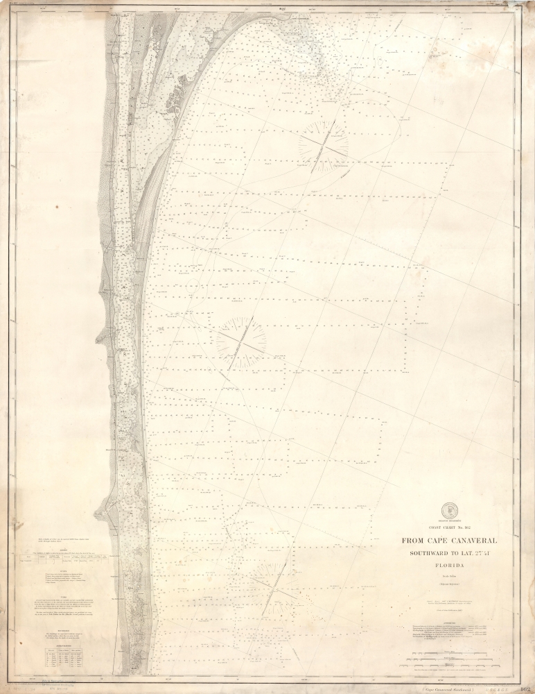
Coast Chart No. 162 From Cape Canaveral Southward to Lat. 27° 41' Florida.
1903 (dated) 44 x 34 in (111.76 x 86.36 cm) 1 : 80000
1903 (dated) 44 x 34 in (111.76 x 86.36 cm) 1 : 80000
Description
This is a 1903 United States Coast and Geodetic Survey nautical chart or map of Cape Canaveral, Florida. The map depicts the coast of Florida from Cape Canaveral to La Roche and from the Florida East Railway line that ran along the coast to the Atlantic Ocean. Highly detailed, myriad depth soundings are noted throughout, particularly in the Indian River and Banana River. Several towns are labeled, including Cape Canaveral, Melbourne, and Houston. Notes concerning the light at Cape Canaveral, buoys, tides, and soundings are situated along the left border and three different scales (one in statute miles, nautical miles, and kilometers) are included in the lower right corner.
Publication History and Census
This map was created and originally published in 1887, while F.M. Thorn and B.A. Colonna were in charge of the U.S.C.G.S. and this example was updated with new data and reissued in 1903. We note three examples of the 1887 edition cataloged in OCLC which are part of the collections at the University of Chicago, the Washington State Library, and Stanford University.CartographerS
The Office of the Coast Survey (1807 - present) founded in 1807 by President Thomas Jefferson and Secretary of Commerce Albert Gallatin, is the oldest scientific organization in the U.S. Federal Government. Jefferson created the "Survey of the Coast," as it was then called, in response to a need for accurate navigational charts of the new nation's coasts and harbors. The spirit of the Coast Survey was defined by its first two superintendents. The first superintendent of the Coast Survey was Swiss immigrant and West Point mathematics professor Ferdinand Hassler. Under the direction of Hassler, from 1816 to 1843, the ideological and scientific foundations for the Coast Survey were established. These included using the most advanced techniques and most sophisticated equipment as well as an unstinting attention to detail. Hassler devised a labor intensive triangulation system whereby the entire coast was divided into a series of enormous triangles. These were in turn subdivided into smaller triangulation units that were then individually surveyed. Employing this exacting technique on such a massive scale had never before been attempted. Consequently, Hassler and the Coast Survey under him developed a reputation for uncompromising dedication to the principles of accuracy and excellence. Unfortunately, despite being a masterful surveyor, Hassler was abrasive and politically unpopular, twice losing congressional funding for the Coast Survey. Nonetheless, Hassler led the Coast Survey until his death in 1843, at which time Alexander Dallas Bache, a great-grandson of Benjamin Franklin, took the helm. Bache was fully dedicated to the principles established by Hassler, but proved more politically astute and successfully lobbied Congress to liberally fund the endeavor. Under the leadership of A. D. Bache, the Coast Survey completed its most important work. Moreover, during his long tenure with the Coast Survey, from 1843 to 1865, Bache was a steadfast advocate of American science and navigation and in fact founded the American Academy of Sciences. Bache was succeeded by Benjamin Pierce who ran the Survey from 1867 to 1874. Pierce was in turn succeeded by Carlile Pollock Patterson who was Superintendent from 1874 to 1881. In 1878, under Patterson's superintendence, the U.S. Coast Survey was reorganized as the U.S. Coast and Geodetic Survey (C & GS) to accommodate topographic as well as nautical surveys. Today the Coast Survey is part of the National Oceanic and Atmospheric Administration or NOAA as the National Geodetic Survey. More by this mapmaker...
Frank Manly Thorn (December 7, 1836 - 1907) was an American businessman, politician, and lawyer who served as the sixth Superintendent of the Coast and Geodetic Survey who holds the distinction of being the first non-scientist to hold the position. Born in Erie County, New York, near Buffalo, Thorn attended local schools and then the Fredonia Academy in Fredonia, New York. After graduating, he returned to Erie County where he served as a clerk in Surrogate's Court, where his father, a trained lawyer, served as Surrogate Judge. Soon Thorn was enrolled in law school in Albany, New York and eventually became a licensed lawyer himself. This, however, was essentially the end of his legal career. Thorn moved to Pennsylvania in 1860, where he began work in the petroleum industry. In 1867, after the Civil War, he moved back to Erie County and started working in the legal profession, while at the some time establishing a successful fruit orchard and farm. He also began writing and publishing humorous sketches in local newspapers under pseudonyms and performing as an after-dinner speaker and humorist lecturer, ventures at which he apparently had some success. Thorn began his political career in 1870 when he was elected to the Erie County Board of Supervisors, a position he held until 1880. In 1882, Thorn joined Grover Cleveland's successful campaign for Governor of New York and two years later campaigned for Cleveland in his bid for the presidency. Cleveland won the 1884 Presidential Election, and, only a few months later, Cleveland named Thorn Superintendent of the Coast and Geodetic Survey. Thorn replaced Julius Hilgard, who had been forced to resign in disgrace after James Q. Chenowith and the Allison Commission found him to be a drunkard and unable to lead the Survey. In 1889, after Cleveland lost the 1888 Presidential Election, Thorn was replaced as Superintendent by Thomas C. Mendenhall. After leaving office, Thorn returned to his farm in Orchard Park, New York, where he resumed life as a gentleman farmer and public figure. Learn More...
Adolph Lindenkohl (March 6, 1833 – June 22, 1904) was a German-American cartographer and draughtsman active in the United States during the second part of the 19th century. Lindenkohl was born in Niederkaufungen, Hesse Cassel, Germany. He was educated at the Realschule and later at the Poytechnische Schule, both in Cassel. After graduating in 1852 he emigrated to the United States where, for 2 years, he taught mathematics before taking a position with the United States Coast Survey. Lindenkhol served as a topographer in the Union Army during the American Civil War, translating Coast Survey methodology and technique to land-side surveys for military use. This experience he later translated to other projects, such as the compilation of the first specific map of Alaska as part of the United States (1867). Lindenkohl was a member of the American Association for the Advancement of Science, the Washington Academy of Sciences, the Philosophical Society of Washington and the National Geographic Society. He retained his position with the Coast Survey until his death in 1904. Learn More...
Condition
Good. Backed on linen. Toning. Soiling.
References
OCLC 317745120.