This item below is out of stock, but another example (left) is available. To view the available item, click "Details."
Details
1930 Town Crier Pictorial Map of Cape Cod, Massachusetts
1930 (dated) $900.00
1934 Kenneth Morang Pictorial Map of Cape Cod, Massachusetts
CapeCod-morang-1934$125.00

Title
Cape Cod.
1934 (dated) 22 x 28 in (55.88 x 71.12 cm)
1934 (dated) 22 x 28 in (55.88 x 71.12 cm)
Description
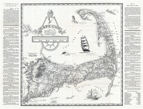
This is a beautiful example of the 1934 Art Deco style pictorial map of Cape Cod. Drawn for the tourist market, this decorative map covers Cape Cod from Race Point and Provincetown to Buzzard bay. The left and right margins feature various notes containing important information for 'Visitors who wish to see the Real Cape Cod…' with details on 'Beautiful Trips off the Main Highways.' The map is exceptionally beautiful and notes lighthouse stations, important towns, cities, including Monument Beach, Chatham, Barnstable, Provincetown among several others. Various ships are shown sailing in the sea along with an illustration of the Sacred Cod of Massachusetts. The title features a compass rose and a sea gull. A key below the title marks various roads. Several points of interests are noted throughout the map with amusing notes including 'from a point off here laid the German Submarine which fired the only shot to land on American soil in the World War,' 'near the end (or if you prefer, the beginning) of the state long bridal trail which reaches to the Berkshires,' etc. This map was drafted by Kenneth e. Morang and published by the Cape Cod Chamber of Commerce, dept. 41M, Hyannis, Massachusetts in 1934.
Condition
Very good. Minor wear along original folds. Blank on verso. Professionally flattened and backed with Japanese tissue.

