
This item below is out of stock, but another example (left) is available. To view the available item, click "Details."
Details
1902 Walker Cycling Map of Cape Cod, Nantucket, Martha's Vineyard, Massachusetts
1902 (dated) $600.00
1917 Walker Map of Cape Cod
CapeCod-walker-1917$175.00

Title
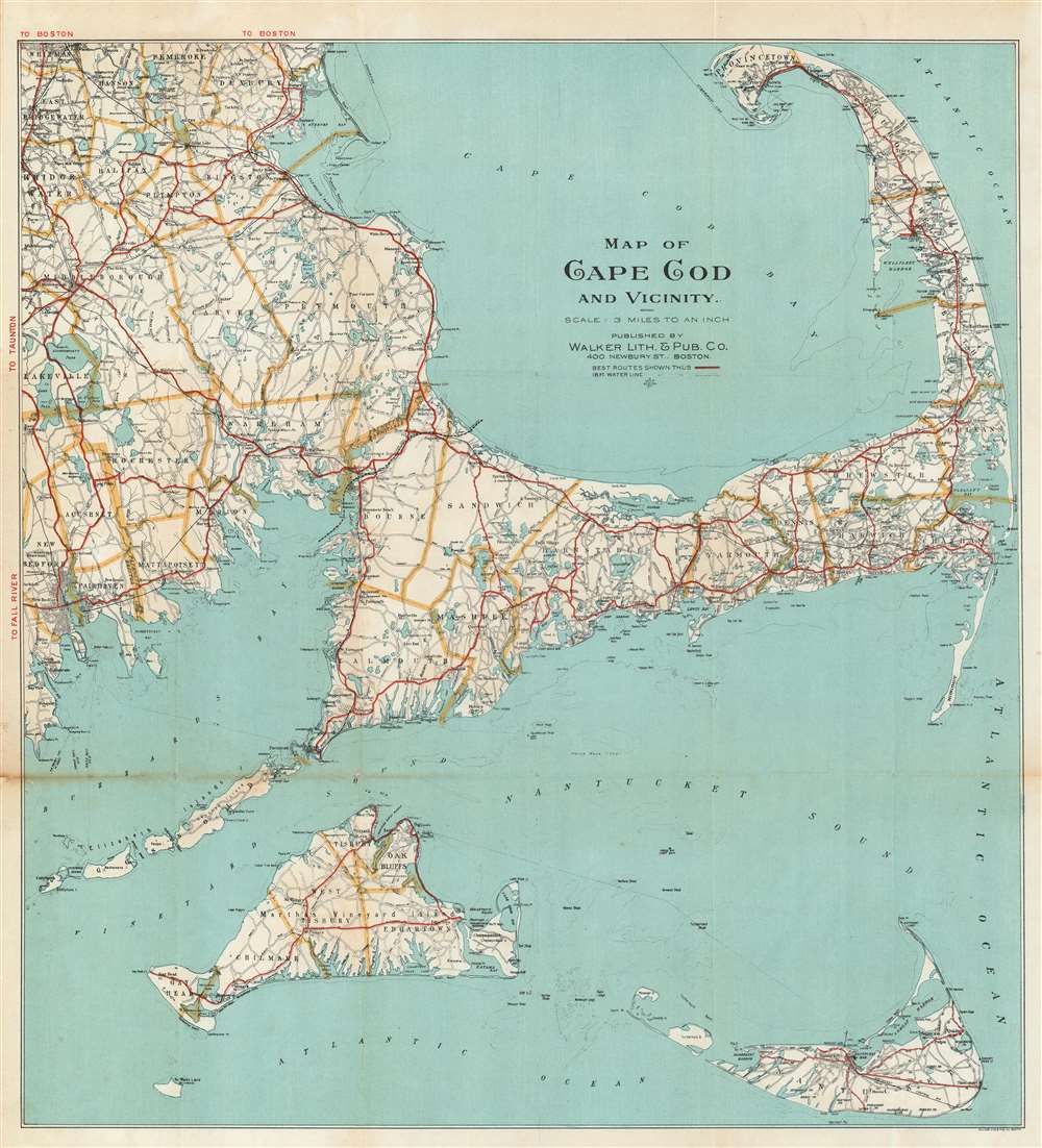
Map of Cape Cod and Vicinity.
1917 (undated) 21.25 x 19.25 in (53.975 x 48.895 cm) 1 : 190080
1917 (undated) 21.25 x 19.25 in (53.975 x 48.895 cm) 1 : 190080
Description
This is a 1917 Walker Lithographic and Publishing Company map of Cape Cod and vicinity. The map depicts the region from New Bedford to the Atlantic Ocean and from Whitman and Provincetown to Nantucket. Created as a road map, Walker identifies the 'best routes' throughout the region by solid red lines. Myriad other roads are illustrated, some of which are labeled. Numerous cities are labeled, including Hyannisport, Yarmouth, W. Yarmouth, Prospect Hill, and Provincetown. Counties are labeled with big block letters and are bordered by thick beige lines, making it easy to differentiate between them. Buzzards Bay and Cape Cod Bay are also illustrated and labeled, as are numerous other bays, points, and other coastal landmarks. Both Martha's Vineyard and Nantucket are included and illustrated in detail.
Publication History and Census
This map was created and published by the Walker Lithographic and Publishing Company in 1917. As this piece is undated and was issued in several different editions, it is difficult to state for certain how many examples are part of institutional collections. We do know that an example is part of the collection at the Norman B. Leventhal Map Center at the Boston Public Library.Cartographer
George Hiram Walker (January 4, 1852 - November 14, 1927) was a Boston based publisher of books, views, and maps active in the late 19th and early 20th centuries. Born in Springfield, Vermont, Walker started his life as a dry goods merchant but developed an active interest in publishing during the early 1870s. Walker began publishing in 1878 when he partnered with an unknown New York Firm. Two years later, Walker brought the operation in house by partnering with his brother, Oscar W. Walker, in the opening of a lithography studio at 81 Milk Street, Boston. Shortly thereafter the firm expanded to new offices at 160 Tremont Street, Boston. The Walker brothers produced a large corpus of works, most of which focused on travel and tourism in New England. Walker also established the Walker-Gordon Milk Laboratory with Dr. Thomas Morgan Rotch and Gustave Gordon. This interesting investment was based on the premise that infant deaths could be avoided by providing higher quality milk. The company eventually became a great success, producing a high-quality cow milk that closely resembled human breast milk. In the process the Walker-Gordon laboratory developed many of the dairy health standards that are still with us today. Walker married Irene L. Loud on March 25, 1885. More by this mapmaker...
Condition
Very good. Even overall toning. A couple of minor wormholes near centerfold. Light wear along original centerfold. Blank on verso.
References
Boston Public Library, Normon B. Leventhal Map Center G3762.C35 1917 .W3.