
1966 Gulf American Land Corp. / Gousha Map of Cape Coral, Florida

This item has been sold.
This is Cape Coral Florida / Cape Coral Pictorial and Giant Florida Map.
Florida's Waterfront Wonderland.
Florida's Waterfront Wonderland.
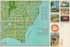
This is an unrecorded c. 1966 Gulf American Land Corporation and H. M. Gousha map of Cape Coral, Florida. It presents the community when it was ground zero for Florida's Postwar population boom, one of the fastest growing areas in one of the fastest growing states in the country.A Closer Look
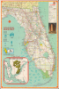
The map shows the Cape Coral development along the shores of the Caloosahatchee River in southwestern Florida. Streets are labeled throughout, while 33 sites are numbered and listed in an index at right. These range from parks, schools, and churches to restaurants, golf courses, and model home villages. Photographs and captions at right present the idyllic living conditions of the community, complete with fishing, barbecuing, and multiple activities at 'Cape Coral's magnificent million-dollar Yacht and Racquet Club.'The verso 'giant' map of Florida focuses on the state's roads, including the recently-designated interstate highway system, with a detailed system of classification explained in the legend at right and mileage between cities and towns recorded. County and state lines are traced, while cities and large towns, state parks, airports, and other features are noted. An inset at bottom-left displays Cape Coral within the wider Cape Coral-Ft. Myers region. Graphics at left emphasize the explosive economic and population growth of Florida, while a photograph at right displays the Gulf American Land Corporation's national headquarters building in Miami.
Cape Coral and the Gulf American Land Corporation
Cape Coral, Florida, was founded by Baltimore real estate developers Leonard and Jack Rosen. The brothers purchased the Redfish Point peninsula in 1957 with the intention of developing a master-planned, organized community under the auspices of the Gulf American Land Corporation (GALC). The development was marketed as a 'Waterfront Wonderland,' with over 400 miles of canals. The Rosens employed aggressive marketing strategies, including nationwide advertising, free 'dinner and a pitch' presentations, and chartered flights for planeloads of prospective buyers from the Northeast and Midwest. After the first four houses were completed in May 1958, the city grew very rapidly, with the GALC becoming the largest land sales company in the country in the following years.By the 1970s, the wider economic situation and backlash against the company's aggressive sales tactics and cavalier environmental practices (rampant canal digging) led it to file Chapter 11 bankruptcy in 1975, but the city continued to grow nonetheless. Cape Coral was incorporated as a city in 1970, transitioning from a developer-controlled community to a self-governed city. Over the decades, Cape Coral has evolved into one of the largest cities in Florida by area, known for its family-friendly environment, extensive canal system, and vibrant community life. In 2017, Forbes named Cape Coral America's fastest growing city.
Publication History and Census
Though not explicitly credited, the recto map was prepared by the GALC, while the verso map modifies an existing H. M. Gousha Co. map of Florida. The recto is undated, but the verso map is dated 1966. We have been unable to locate any examples of this map in institutional collections.Cartographers
H.M. Gousha Company (1926 - 1961) was one of the major publishers of road maps and atlases during the mid-20th century. Founded in Chicago 1926 by former Rand McNally sales executive Harry Mathais Gousha, Gousha quickly became a competitor of Rand McNally thanks to its Touraide, a spiral-bound book with road maps, points of interest, and accommodations that was custom assembled for each client. Gousha moved its headquarters to San Jose, California in 1947. In 1961, the firm was acquired by the Times Mirror Company, and then by Simon and Schuster in 1987. What remained of Gousha was finally acquired by Rand McNally in 1996, and subsequently much of the company's archives were donated to the Newberry Library. Further Details...
Harry Mathais Gousha (May 16, 1892 – September 24, 1970) was an American map publisher. Gousha worked for Rand McNally in Chicago as a sales executive before founding the H.M. Gousha Company in 1926. Gousha's company quickly became a competitor with Rand McNally thanks to its Touraide, a spiral-bound book with road maps, points of interest, and accommodations that was custom assembled for each client. Gousha retired in 1942 but stayed on as a consultant. Gousha and the company's headquarters moved to San Jose, California in 1947. In 1961, the H.M. Gousha Company was acquired by the Times Mirror Company, and then by Simon and Schuster in 1987. What remained of Gousha was finally acquired by Rand McNally in 1996, and subsequently much of the company's archives were donated to the Newberry Library. Further Details...
Condition
Very good. Light wear along original fold lines. Road map of Florida on verso.