
1700 / 1719 Renier and Josue Ottens Map of England

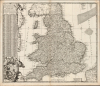

Regni Angliae Nova Tabula, Exhibens Principatum Walliae et aliarum Provinciarum, Civitatum, Oppidorum, una cum itineribus ab uno in aliam civitatem.
Celebrating the Glorious Revolution.
- Digital Map Information
- Suitable for large format printing
- Full resolution TIFF file
- ICC color profile embedded
- Delivered instantly via download link
Celebrating the Glorious Revolution.
This is Johannes de Ram's c. 1689 map of the kingdom of England. The present example is the third state, published c. 1730 by Renier and Josue Ottens, whose imprint appears at bottom-center. The map was published in the wake of the Glorious Revolution (1688 - 1689), the deposition of King James II, and his replacement by Mary II and William III of Orange. This Dutch-produced map celebrates the Revolution as a Dutch triumph; nonetheless, the extensive English text suggests it was intended for a British audience.A Closer Look
The map covers England from Berwick-upon-Tweed in Northumberland to the English Channel. The coast of Flanders appears in the lower right, while the east coast of Ireland can be seen across the Irish Sea. The map includes as many cities, rivers, and roads as could be fit; it is a densely detailed work. Along the shorelines and well into the North Sea, shallows are marked; many are named. To the left is a large table listing cities and market towns, giving both their coordinates and their distance from London. Consistent with both the second and third states of this map, the language of the table is English. (The unacquirably rare first state presents the table in Latin). The base of the table is decorated with an allegorical cartouche in which a warrior - representing William III - stands upon a prostrate leonine figure representing England. The triumphant William offers his hand to a kneeling, crowned Queen Mary. Atop the cartouche, two putti flank the Orange-Stuart coat of arms. To the left, a figure wearing a mural crown bears a banner reading Restituit Rem, 'He Restored the Matter,' alluding to William III's returning the British Crown to a Protestant regime.Publication History and Census
This map was engraved by Johannes de Ram as early as 1689, and in that first state, the table of cities was printed in Latin. We see no examples of this first state clearly represented in institutional collections and are aware only of the example cited by Shirley from his own collection. Some examples of the second state, with the English table but still displaying the De Ram imprint and dedicatory cartouche at upper right, are cataloged and have appeared on the market. We see eleven examples conforming to this third, Ottens, state listed in OCLC.Cartographers
Ottens (fl. c. 1680 - 1785) was a prominent Amsterdam map publishing family active for nearly 100 years. Joachim Ottens (1663 - 1719) was born in Amsterdam to a family of seafarers and educated in Amsterdam's Evangelical Lutheran community. He likely learned copperplate engraving under Frederick de Wit (1629 - 1706), for whom he worked until about 1710. In 1710, he was admitted to the Sint-Lucasgilde (Guild of St. Luke) and, in 1711, Joachim founded his own firm. Although Joachim died only a few years later, in 1719, his widow continued the business, either publishing as either 'I. Ottens', 'Ottens', or 'In de Wereldcaert' [In the World Map]. In 1726, Joachim Otten's sons, Renier (1698 - 1750) and Joshua (1698 - 1750), established a partnership and generally published as 'R. and I. Ottens'. Although they ran separate shops, on Nieuwendijk and Kalverstraat, they worked jointly as a singular business until Renier's death in 1750, at which point Joshua assumed full control. After Joshua's death in 1765, his widow continued the firm with their son, Renier II, changing the imprint to 'Joshua and Reinier Ottens.' Joshua's widow, Johanna de Lindt, held an auction sale of their engraved plates in 1784. Ottens' work stands out in that all of their maps were separate issues, though often found compiled into special, made-to-order multi-volume composite Atlas factice works, such as the Atlas. Some examples of the Atlas include over 800 separately issued maps. Because they were not uniformly issued in standard atlases, Ottens maps are often of the utmost rarity and are notable for their exceptionally rich engraving. Further Details...
Luggert van Anse (fl. 1677-1716) was a Dutch map engraver, who worked in the shops of Visscher, van Keulen, and Pieter Husson. He appears to have been prolific, but as is often the case with Dutch engravers employed by larger printers or publishers, he would have been considered more of a workman than an artist, and consequently his education and early life are poorly documented. Further Details...
Condition
Very good. Marginal mends to upper corners, not impacting printed image.
References
OCLC 611361168. Shirley, R., Printed Maps of the British Isles 1650 - 1750, De Ram 1 State 3, p.120.