1853 U.S. Coast Survey Chart of Cape Flattery, Neah Bay, Olympic Peninsula
CapeFlattery-uscs-1853-2$800.00

Title
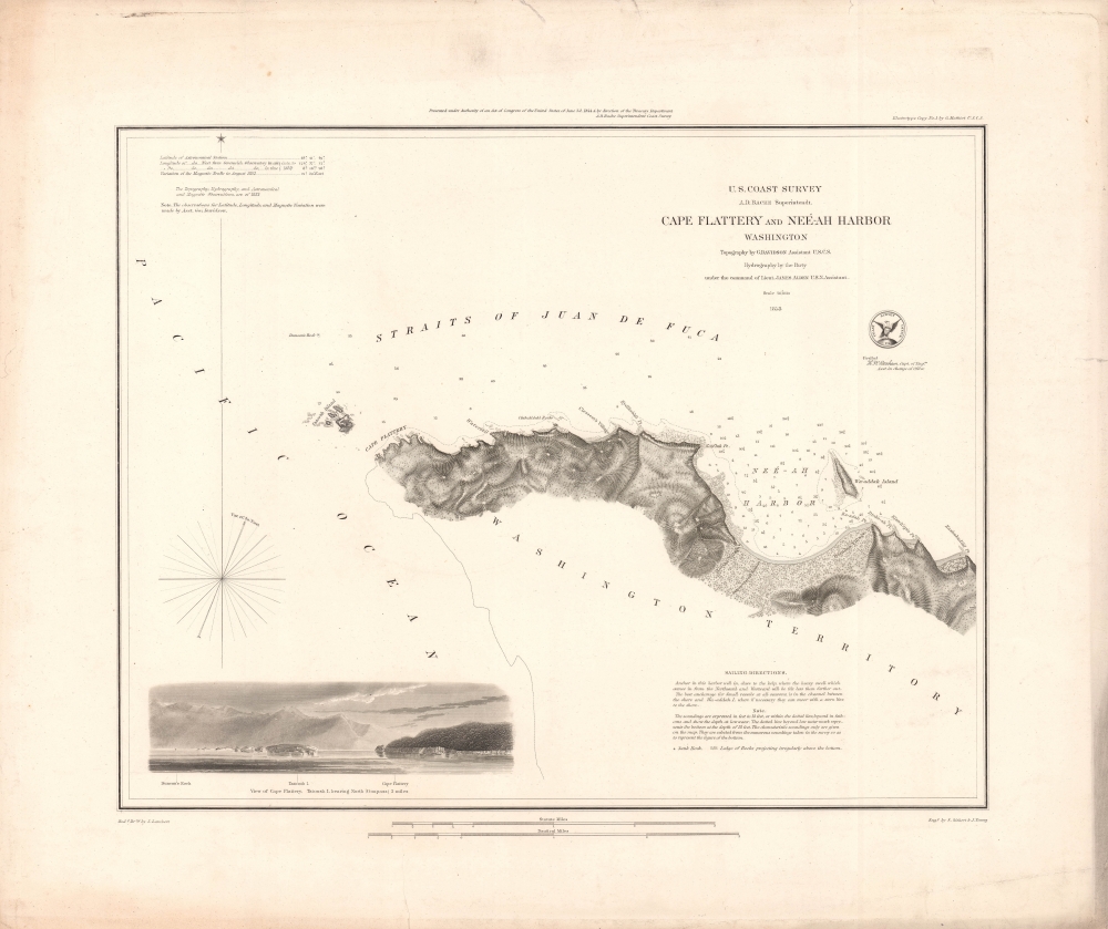
Cape Flattery and Neé-ah Harbor, Washington.
1853 (dated) 14.25 x 17.25 in (36.195 x 43.815 cm) 1 : 40000
1853 (dated) 14.25 x 17.25 in (36.195 x 43.815 cm) 1 : 40000
Description
A rare 1853 nautical chart of Cape Flattery and Neah Harbor on the Juan de Fuca Strait in Washington State, the furthest northwest point in the contiguous United States. This example is printed on thick paper, suggesting intended shipboard use.
The presence and influence of indigenous peoples is immediately evident in the villages indicated and placenames used on the chart (the area is today part of the Makah Indian Reservation). A range of navigational information is provided, including soundings, magnetic variations, shoals, rocks, and sailing directions at bottom-right. At bottom-left is a view, oriented towards the southeast, of Cape Flattery and Tatoosh Island, where a lighthouse (the Cape Flattery Light) was built the following year (1854) which still stands. Behind, the peaks of the Olympic Mountains dominate the horizon.
A Closer Look
Coverage includes Cape Flattery, Neah Bay, and the mouth of the Juan de Fuca Strait, where it meets the Pacific Ocean. This area, corresponding to the northwestern coast of the Olympic Peninsula, was important for both navigational and geopolitical reasons, as the border between the United States and British Columbia was still in dispute at the time.The presence and influence of indigenous peoples is immediately evident in the villages indicated and placenames used on the chart (the area is today part of the Makah Indian Reservation). A range of navigational information is provided, including soundings, magnetic variations, shoals, rocks, and sailing directions at bottom-right. At bottom-left is a view, oriented towards the southeast, of Cape Flattery and Tatoosh Island, where a lighthouse (the Cape Flattery Light) was built the following year (1854) which still stands. Behind, the peaks of the Olympic Mountains dominate the horizon.
Publication History and Census
This chart was produced (using electrotype) by the U.S. Coast Survey in 1853. It is printed on heavy stock, intended for maritime use, rather than the more common thin, fragile paper used for charts folded into the annual Report of the Superintendent of the Coast Survey. The chart is independently cataloged by Brigham Young University, the National Library of Scotland, the University of Wisconsin-Milwaukee, and the Biblioteca Nacional de España, though these examples are more likely to be from the Superintendent's Report.Cartographer
The Office of the Coast Survey (1807 - present) founded in 1807 by President Thomas Jefferson and Secretary of Commerce Albert Gallatin, is the oldest scientific organization in the U.S. Federal Government. Jefferson created the "Survey of the Coast," as it was then called, in response to a need for accurate navigational charts of the new nation's coasts and harbors. The spirit of the Coast Survey was defined by its first two superintendents. The first superintendent of the Coast Survey was Swiss immigrant and West Point mathematics professor Ferdinand Hassler. Under the direction of Hassler, from 1816 to 1843, the ideological and scientific foundations for the Coast Survey were established. These included using the most advanced techniques and most sophisticated equipment as well as an unstinting attention to detail. Hassler devised a labor intensive triangulation system whereby the entire coast was divided into a series of enormous triangles. These were in turn subdivided into smaller triangulation units that were then individually surveyed. Employing this exacting technique on such a massive scale had never before been attempted. Consequently, Hassler and the Coast Survey under him developed a reputation for uncompromising dedication to the principles of accuracy and excellence. Unfortunately, despite being a masterful surveyor, Hassler was abrasive and politically unpopular, twice losing congressional funding for the Coast Survey. Nonetheless, Hassler led the Coast Survey until his death in 1843, at which time Alexander Dallas Bache, a great-grandson of Benjamin Franklin, took the helm. Bache was fully dedicated to the principles established by Hassler, but proved more politically astute and successfully lobbied Congress to liberally fund the endeavor. Under the leadership of A. D. Bache, the Coast Survey completed its most important work. Moreover, during his long tenure with the Coast Survey, from 1843 to 1865, Bache was a steadfast advocate of American science and navigation and in fact founded the American Academy of Sciences. Bache was succeeded by Benjamin Pierce who ran the Survey from 1867 to 1874. Pierce was in turn succeeded by Carlile Pollock Patterson who was Superintendent from 1874 to 1881. In 1878, under Patterson's superintendence, the U.S. Coast Survey was reorganized as the U.S. Coast and Geodetic Survey (C & GS) to accommodate topographic as well as nautical surveys. Today the Coast Survey is part of the National Oceanic and Atmospheric Administration or NOAA as the National Geodetic Survey. More by this mapmaker...
Condition
Good. Tears in margins extending quarter to half inch, professionally closed on verso.
References
Rumsey 2470.059. OCLC 316647277, 431784334.