This item has been sold, but you can get on the Waitlist to be notified if another example becomes available, or purchase a digital scan.
1818 Pinkerton Map of Northeastern South America (Venezuela, Guyana, Surinam)
Caracas-pinkerton-1818$175.00

Title
The Caracas.
1818 (undated) 20 x 27.5 in (50.8 x 69.85 cm)
1818 (undated) 20 x 27.5 in (50.8 x 69.85 cm)
Description
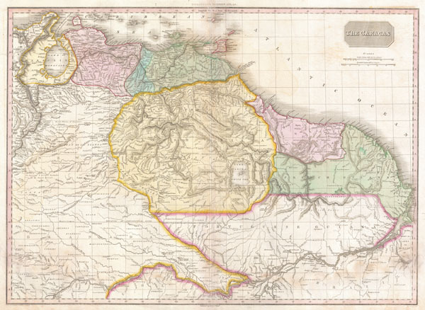
This is a stunning, highly detailed, and extremely interesting map of northeastern South America. Covers the modern day countries of Venezuela, British Guyana, French Guyana, Surinam and parts of Brazil. Pinkerton offers impressive detail throughout noting indigenous groups, missions, towns and cities, swamps, mountains, and river systems. Upper right hand quadrant features the title plate and two distance scales, one in British Miles and the other in Spanish Leagues.
Cartographically speaking this is an often neglected part of the world - especially in the early 19th century. Though the coastlands had been well mapped early in the 16th century, the interior was rarely penetrated. The combination of mountainous terrain, daunting jungles, malaria, and unfriendly indigenous groups combine to make this area all but unexplorable - even today. Nonetheless, Pinkerton make a commendable attempt to piece together early conquistador accounts, explorer's journals, missionary records, and indigenous reports into a coherent mapping of the area.
Probably the most interesting aspect of this map is Pinkerton's treatment of the apocryphal Lake Parima. Lake Parima was first identified by Sir Walter Raleigh in the 16th century - though he admittedly never saw the lake himself. Raleigh associated the lake with indigenous legends of Manoa and the supposed site of El Dorado. Many early maps actually show 'El Dorado' on the shores of Lake Parima, though Pinkerton curiously does not. However, his rendition of Lake Parima is vastly larger than most previous examples from the late 18th century - even those by other English cartographers such as Laurie and Whittle. The reality of Lake Parima and the Manoa is based upon Raleigh's misinterpretation of local trade networks. The Manoas were a river trading tribe based in the Amazon. Each year during the rainy season flooding on the Orinoco and Parima rivers would create a large flood plain and open channels of trade between the two otherwise unconnected regions. Raleigh misinterpreted these watery trade channels as a great lake.
This map's curious elements, however, do not end with Lake Parima. Pinkerton makes several bold attempts to map the various unexplored river systems of the region. He offers duly noted speculative courses for the Orinoco, the Maroni and the Rio Negro, among others. He also notes the sites of various battles and the bases of rebels and escaped slaves.
Drawn by L. Herbert and engraved by Samuel Neele under the direction of John Pinkerton. This map comes from the scarce American edition of Pinkerton's Modern Atlas, published by Thomas Dobson & Co. of Philadelphia in 1818.
CartographerS
John Pinkerton (February 17, 1758 - March 10, 1826) was an Scottish writer, historian, and cartographer. Pinkerton was born in Edinburgh, Scotland. He was a studious youth with a passion for the classics. As a young man, he studied at Edinburgh University before apprenticing as a lawyer. Around this time, he began writing, with his first book, Elegy on Craigmillar Castle published in 1776. Pinkerton moved to London in 1781 to pursue his writing career in earnest. He successfully published several works of literature, poetry, and history. Pinkerton proved passionate in his literary and historical writings, but his correspondence with other cartographers has been labeled as aggressive, even insane. In addition to his work as a writer and historian, Pinkerton was one of the leading masters of the Edinburgh school of cartography which flourished from roughly 1800 to 1830. Pinkerton and his contemporaries (Thomson and Cary) redefined European cartography by abandoning typical 18th century decorative elements such as elaborate title cartouches and fantastical beasts in favor of detail and accuracy. Pinkerton's principle work is Pinkerton's Modern Atlas published from 1808 through 1815 with a special American reissue by Dobson and Co. in 1818. Pinkerton relocated to Paris in 1818, where he managed his publishing business until his death in 1826. More by this mapmaker...
Thomas Dobson (1751 - 1823) was an American publisher active in Philadelphia during the late 18th and early 19th centuries. Dobson was born in Edinburgh, Scotland in 1751 and emigrated to Philadelphia c. 1780. In Philadelphia, he established a successful printing business by republishing edited and updated versions of important British reference materials in matching quality but at a much lower price point. He is best known for publishing the first American edition of the Encyclopedia Britannica. He also published America's first Hebrew Bible. Cartographically Dobson's most notable work is 1818 republication of Pinkerton's fantastic Modern Atlas. Learn More...
Source
Pinkerton, J., A Modern Atlas, from the Lates and Best Authorities, Exhibiting the Various Divisions of the World with its chief Empires, Kingdoms, and States; in Sixty Maps, carefully reduced from the Larges and Most Authentic Sources. 1818, Philadelphia, Thomas Dobson Edition.
Condition
Very good condition. Minor damp staining in lower quadrants. Original centerfold exhibits light toning. Blank on verso.
References
Rumsey 0732.054. Phillips (Atlases) 724. National Maritime Museum, 409.