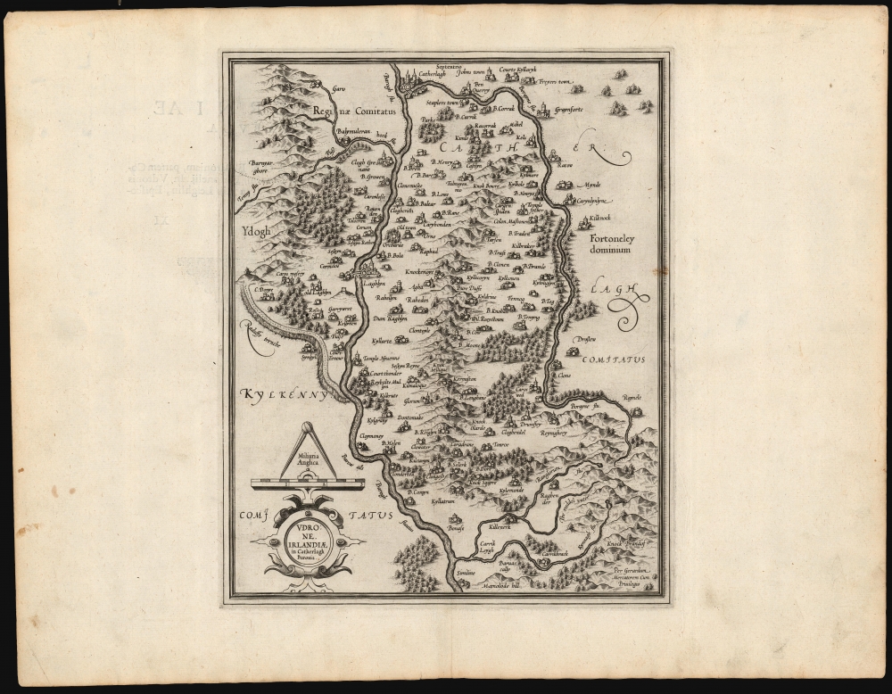
1595 Mercator Map of Udrone / Carlow County, Ireland
Carlow-mercator-1595$450.00

Title
Udrone, Irlandiae in Catherlagh Baronia.
1595 (undated) 13.5 x 10.75 in (34.29 x 27.305 cm) 1 : 96000
1595 (undated) 13.5 x 10.75 in (34.29 x 27.305 cm) 1 : 96000
Description
This is Gerard Mercator's map of the Barony of Idrone in County Carlow, Ireland, here in its 1595 first atlas edition.
A Closer Look
Idrone (Udrone on the map) is bordered by the River Barrow to the west, and the River Burren to the East. The map includes the towns of Carlow (Catherlagh) and Leighlinbridge (Laghlyn) as well as many smaller locales. Hills and forests are shown pictorially. Although many placenames have changed, as with the above towns, the map is remarkably accurate and includes many recognizable places (for example Old Laghlyn / Oldleighlin, Ratow / Rathoe, Mihel / Moyle, Knok Squyre / Knocksquire, Kylemonde / Killedmond). The map includes an ancient earthwork, 'Raduffe Trenche.' This marks County Carlow's border with Kilkenny west of the River Barrow. (Locally it is known as the 'Gripe of the Pig'.)Resulting from Actual Survey
Mercator initially addressed the geography of Ireland in his 1564 wall map of the British Isles. His delineation of Ireland in that map was influential, to the extent that Ortelius reproduced it faithfully in his 1573 map. By the time Mercator produced the present map, however, he had moved beyond that earlier work. The level of detail exhibited, along with the ubiquity of reasonably accurate Irish place names, suggests that Mercator had access to detailed surveys, executed firsthand, by an Irish or English mapmaker. The most convincing candidate is the surveyor Robert Lythe, whose surveys added over three thousand Irish place names to the historical record during his 1567-1571 tenure as military engineer under Sir Henry Sidney, the Queen's deputy in Ireland. Although Lythe eventually mapped the entire island, his surveys between 1569 and 1570 were focused specifically on the region covered here.Publication History and Census
Mercator engraved this map for inclusion in his Atlas, although he would not live to see it published as this first edition appeared a year after his death. The plates were later purchased by Jodocus Hondius, who continued to use them as the basis for his own atlases, gradually adding additional plates. The map remained in the Hondius / Jansson atlases unchanged until 1644. This present map conforms typographically with examples of the 1595 first Latin edition of Mercator's Atlas. In various editions, examples appear on the market from time to time, and the map is reasonably well represented in institutional collections.CartographerS
Gerard Mercator (March 5, 1512 - December 2, 1594) is a seminal figure in the history of cartography. Mercator was born near Antwerp as Gerard de Cremere in Rupelmonde. He studied Latin, mathematics, and religion in Rupelmonde before his Uncle, Gisbert, a priest, arranged for him to be sent to Hertogenbosch to study under the Brothers of the Common Life. There he was taught by the celebrated Dutch humanist Georgius Macropedius (Joris van Lanckvelt; April 1487 - July 1558). It was there that he changed him name, adapting the Latin term for 'Merchant', that is 'Mercator'. He went on to study at the University of Louvain. After some time, he left Louvain to travel extensively, but returned in 1534 to study mathematics under Gemma Frisius (1508 - 1555). He produced his first world map in 1538 - notable as being the first to represent North America stretching from the Arctic to the southern polar regions. This impressive work earned him the patronage of the Emperor Charles V, for whom along with Van der Heyden and Gemma Frisius, he constructed a terrestrial globe. He then produced an important 1541 globe - the first to offer rhumb lines. Despite growing fame and imperial patronage, Mercator was accused of heresy and in 1552. His accusations were partially due to his Protestant faith, and partly due to his travels, which aroused suspicion. After being released from prison with the support of the University of Louvain, he resumed his cartographic work. It was during this period that he became a close fried to English polymath John Dee (1527 - 1609), who arrived in Louvain in 1548, and with whom Mercator maintained a lifelong correspondence. In 1552, Mercator set himself up as a cartographer in Duisburg and began work on his revised edition of Ptolemy's Geographia. He also taught mathematics in Duisburg from 1559 to 1562. In 1564, he became the Court Cosmographer to Duke Wilhelm of Cleve. During this period, he began to perfect the novel projection for which he is best remembered. The 'Mercator Projection' was first used in 1569 for a massive world map on 18 sheets. On May 5, 1590 Mercator had a stroke which left him paralyzed on his left side. He slowly recovered but suffered frustration at his inability to continue making maps. By 1592, he recovered enough that he was able to work again but by that time he was losing his vision. He had a second stroke near the end of 1593, after which he briefly lost speech. He recovered some power of speech before a third stroke marked his end. Following Mercator's death his descendants, particularly his youngest son Rumold (1541 - December 31, 1599) completed many of his maps and in 1595, published his Atlas. Nonetheless, lacking their father's drive and genius, the firm but languished under heavy competition from Abraham Ortelius. It was not until Mercator's plates were purchased and republished (Mercator / Hondius) by Henricus Hondius II (1597 - 1651) and Jan Jansson (1588 - 1664) that his position as the preeminent cartographer of the age was re-established. More by this mapmaker...
Robert Lythe (fl. 1556-1571) was an English surveyor and mapmaker. Nothing is known of his early life. Although he appears to have specialized as a military surveyor, he was sufficiently broadly educated to be able to make references to hydrography, land quality, natural curiosities and local history in his manuscript maps - which were themselves neatly and attractively executed. His earliest known work was a map of the vicinity of Calais produced during an Anglo-French border dispute. His farthest-reaching work were the Irish surveys he executed between 1567 and 1570, on behalf of the British government, in order to better understand how best to garrison and colonize Ireland following the Tudor conquest. Though these surveys were not for many years broadly disseminated, they would inform to a greater or lesser extent the maps executed by Mercator, Plancius, Boazio and Norden. Jodocus Hondius drew on Lythe for the Ireland maps he produced for van der Keere and Speed: thereafter, Speed’s 1610 map of Ireland incorporating Lythe’s surveys would provide the basis for most 17th century maps of the island. Learn More...
Source
Mercator, G., Atlas sive Cosmographicae, (Amsterdam) 1595.
Mercator's Atlas is one of the most important works in the history of cartography. Although in fact Ortelius was the first to publish a proper atlas, the Teatrum Orbis Terrarum, Mercator's work the first book to employ the term Atlas for a collection of maps. The term is derived both from the mythical titan, Atlas, who was forced to bear the world upon his shoulders, and the Libyan king, philosopher, and astronomer of the same name that, so the legend goes, constructed the first globe. Mercator dedicated the final 25 years of his life to compile the Atlas. He published two parts during his lifetime in 1585 and 1589, but the final part published posthumously by his son Rumold Mercator, in 1595. The map plates for the Atlas were later acquired by Jodocus Hondius who published the most complete and well known edition in 1606. It was Jodocus who popularized the Atlas and who did the most to elevate Gerard Mercator's name.
Condition
Excellent. Faint stain to right border, else fine with generous margins and a bold strike.
References
OCLC 633645948. Koeman's Atlantes Neerlandici, (Vol. 1), 5915:1.