This item has been sold, but you can get on the Waitlist to be notified if another example becomes available, or purchase a digital scan.
1561 Ruscelli/ Gastaldi Mariner's Map of the World
CartaMarina-ruscelli-1561-2$1,000.00

Title
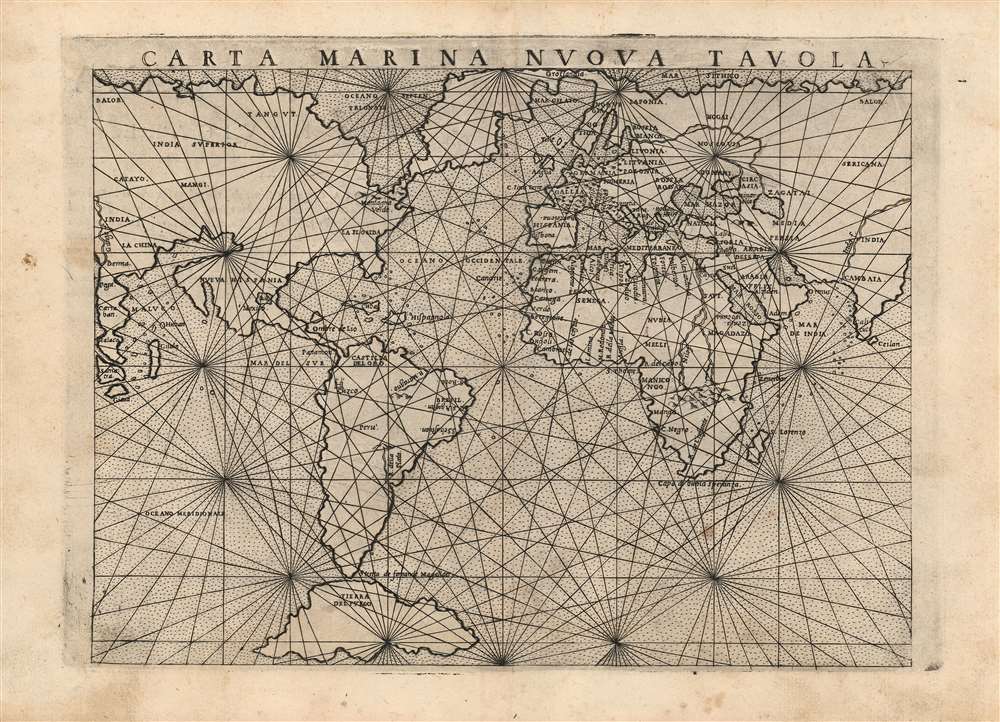
Carta Marina Nuova Tavola.
1561 (undated) 7.5 x 9.5 in (19.05 x 24.13 cm) 1 : 108770000
1561 (undated) 7.5 x 9.5 in (19.05 x 24.13 cm) 1 : 108770000
Description
This is an attractive example of Girolamo Ruscelli's 1561 map of the world,Carta Marina Nuova Tavola. It was one of three maps in Ruscelli's edition of Ptolemy. One of these was Ptolemy's map while two - this, and a double-hemisphere map - were modern works. This striking work, with its array of rhumb lines, was an enlarged and improved version of Giacomo Gastaldi's 1548 Carta Marina Nova Tabula. As such, it reflects the puzzling features of that earlier map: not merely those which differ from modern understanding of the globe, but sharp differences between Gastaldi's own maps of the same period, and indeed differences between this and Ruscelli's other modern map appearing in the same work.
The geography here, preserved from the 1548 map, is distinct from any Gastaldi's other maps thanks to the presence of two great bays appearing in North America: a bay intruding into the Pacific coast north of the unnamed California, and the appearance of the Sea of Verrazano in the northeast. Neither of these appear on any of Gastaldi's other maps. The appearance of the Sea of Verrazano - the wedge-shaped bay bisecting America from the north - may represent an effort by Gastaldi to reconcile his geography with that of his colleague, Sebastian Münster, on whose maps of America and the world that bay had appeared. Münster and Gastaldi were familiar enough with each other's work for the former to write the preface to Gastaldi's 1548 Ptolemy, so it is likely that the idea was one they had discussed. Gastaldi's interpretation of the sea is very different from Münster's however. The German-Swiss scholar's sea appeared to hold out hope for a convenient passage from the Atlantic to the Pacific, whereas Gastaldi's Verrazanean Sea connects not with the Pacific but with a great northern ocean with no connection whatever to either the Atlantic or the Pacific.
Despite Ruscelli's version having been engraved thirteen years after the Gastaldi original, it remains among the earliest maps to show a peninsular California (first appeared on Cabot's 1544 map; Gastaldi had adopted the form as early as 1546.) It shows the Strait of Magellan, and a massive insular Tierra del Fuego - although it does not command the size of the Terra Australis that would appear on Mercator's maps.
Asia and America
One feature held in common with most of Gastaldi's world maps (until 1561) is his emphatic connection of North America and the Asian mainland. On the present work this is unmistakable: the same continent sporting Florida, Mexico and a peninsular California continues onward to reveal the Ganges River at its westward limits; the Malay Peninsula and Sumatra tell the same tale. Gastaldi's conviction on this point ran counter to that of his contemporary Münster, and to many of the mapmakers to follow in the 16th century. (It must be said that European geographers had no concrete evidence of the separation of Asia and America by the Bering Strait until Cook's voyage there in the 18th century.)The geography here, preserved from the 1548 map, is distinct from any Gastaldi's other maps thanks to the presence of two great bays appearing in North America: a bay intruding into the Pacific coast north of the unnamed California, and the appearance of the Sea of Verrazano in the northeast. Neither of these appear on any of Gastaldi's other maps. The appearance of the Sea of Verrazano - the wedge-shaped bay bisecting America from the north - may represent an effort by Gastaldi to reconcile his geography with that of his colleague, Sebastian Münster, on whose maps of America and the world that bay had appeared. Münster and Gastaldi were familiar enough with each other's work for the former to write the preface to Gastaldi's 1548 Ptolemy, so it is likely that the idea was one they had discussed. Gastaldi's interpretation of the sea is very different from Münster's however. The German-Swiss scholar's sea appeared to hold out hope for a convenient passage from the Atlantic to the Pacific, whereas Gastaldi's Verrazanean Sea connects not with the Pacific but with a great northern ocean with no connection whatever to either the Atlantic or the Pacific.
Despite Ruscelli's version having been engraved thirteen years after the Gastaldi original, it remains among the earliest maps to show a peninsular California (first appeared on Cabot's 1544 map; Gastaldi had adopted the form as early as 1546.) It shows the Strait of Magellan, and a massive insular Tierra del Fuego - although it does not command the size of the Terra Australis that would appear on Mercator's maps.
'Carta Marina?'
Despite the title of this little map, and its elaborate latticework of navigator's rhumb lines, this is a work that would plainly be of very little use at sea. That said, its focus is on the seas: very few cities are named, and only the most dramatic land features appear at all. The map's purpose, then, may be to show Gastaldi's ideas about which of the world's seas were navigable, and where one might be able to travel; so the map's 'chartiness' and its nautical title may have been intended to invoke the idea of the sailability of the post-Magellanic world. For even the most housebound armchair traveler, the idea that 'one might be able to get there from here' would have been a compelling message for such a map to deliver.Publication History and Census
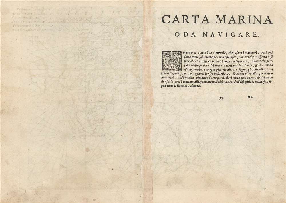
This map was engraved for the 1561 edition of Ruscelli'sLa Geografia di Claudio Tolomeo. The maps of that edition were engraved two-to-a-plate, and consequently the platemark runs off the edge of the sheet at top. Afterwards the plates were divided, and examples from 1574 onwards exhibit a platemark all around the map. This example conforms typographically to the 1574 edition of Ruscelli's work. We see eleven examples of this separate map cataloged in OCLC, in various editions.CartographerS
Girolamo Ruscelli (1500 - 1566) was an Italian polymath, humanist, editor, and cartographer active in Venice during the early 16th century. Born in Viterbo, Ruscelli lived in Aquileia, Padua, Rome and Naples before relocating to Venice, where he spent much of his life. Cartographically, Ruscelli is best known for his important revision of Ptolemy's Geographia, which was published posthumously in 1574. Ruscelli, basing his work on Gastaldi's 1548 expansion of Ptolemy, added some 37 new "Ptolemaic" maps to his Italian translation of the Geographia. Ruscelli is also listed as the editor to such important works as Boccaccio's Decameron, Petrarch's verse, Ariosto's Orlando Furioso, and various other works. In addition to his well-known cartographic work many scholars associate Ruscelli with Alexius Pedemontanus, author of the popular De' Secreti del R. D. Alessio Piemontese. This well-known work, or "Book of Secrets" was a compilation of scientific and quasi-scientific medical recipes, household advice, and technical commentary on a range of topics that included metallurgy, alchemy, dyeing, perfume making. Ruscelli, as Alexius, founded a "Academy of Secrets," a group of noblemen and humanists dedicated to unearthing "forbidden" scientific knowledge. This was the first known experimental scientific society and was later imitated by a number of other groups throughout Europe, including the Accademia dei Secreti of Naples. More by this mapmaker...
Giacomo Gastaldi (c. 1500 - October, 1566) was an Italian astronomer, cartographer, and engineer active in the second half of the 16th century. Gastaldi (sometimes referred to as Jacopo or Iacobo) began his career as an engineer, serving the Venetian Republic in that capacity until the fourth decade of the sixteenth century. During this time he traveled extensively, building a large library relating to voyages and exploration. From about 1544 he turned his attention to mapmaking, working extensively with Gextantiovanni Battista Ramusio, Nicolo Bascarini, and Giovanbattista Pedrezano, as well as taking private commissions for, among others, Venice's Council of Ten. He is credited with the fresco maps of Asia and Africa still extant in the map room of the Doge's Palace. Gastaldi was also one of the first cartographers to embrace copper plate over woodblock engraving, marking an important development in the history of cartography. His 1548 edition of Ptolemy's Geographia was the first to be printed in a vernacular; it was the first to be printed in copperplate. As with his Swiss/German contemporary Münster, Gastaldi's work contained many maps depicting newly discovered regions for the first time, including the first map to focus on the East Coast of North America, and the first modern map of the Indian Peninsula. His works provided the source for the vast majority of the Venetian and Roman map publishers of the 1560s and 70s, and would continue to provide an outsize influence on the early maps of Ortelius, De Jode, and Mercator. Learn More...
Source
Ruscelli, G., La Geografia di Claudio Tolomeo Alessandrino…, (Venice: Vincenzo Valgrisi) 1574.
Beginning in 1561, Girolamo Ruscelli published this important, expanded edition of Giacomo Gastaldi's 1548 Ptolemy. Its maps, engraved in Venice by Giulio Sanuto, were in the main based directly upon those in Gastaldi's 1548 work. The maps were larger format than Gastaldi's, however, and Sanuto's engraving was far clearer and more legible than those appearing in the 1548 work. There are some important additions that distinguish Ruscell's Ptolemy from Gastaldi's. Ruscelli's work contained a map of the habitable world according to Ptolemy, which the Gastaldi lacked; also, the double-hemisphere map appearing in the Ruscelli was new and did not appear in the Gastaldi. Ruscelli's modern map of England was based on the work of George Lily, rather than the Waldseemüller-derived map appearing in the Gastaldi; the Ruscelli is the earliest generally acquirable map of England based on knowledge from someone who lived there. In a fateful innovation, Ruscelli's work included Septentrionalium partium nova tabula,the first copy of Nicolo Zeno's 1558 fraud Carta da Navegar, which introduced a novel mapping of the north parts of the world, including the phantom islands of Frisland, Icaria, Drogeo and Estotiland. Had Ruscelli not copied the Zeno - which had a narrow, brief publication - this preposterous geography would have probably not taken hold. Its inclusion in Ruscelli's beautiful, authoritative and popular work would lead to the adoption of the Zeno map by Mercator, Ortelius, Plancius and their successors, baffling scholars for centuries. Ruscelli's Ptolemy had a long publication history, cementing the influence of the work. It appeared both in Italian and Latin editions, all printed in Venice, throughout the latter 16th century:
- 1561 La Geographia di Claudio Tolomeo Alessandrino, Italian. Venice, Vincenzo Valgrisi.
- 1562 Geographia Cl. Ptolemaei Alexandrini, Latin. Venice, Vincenzo Valgrisi.
- 1564 La Geographia di Claudio Tolomeo Alessandrino, Italian. Venice, Giordano Ziletti.
- 1564 Geographia Cl. Ptolemaei Alexandrini, Latin. Venice, Giordano Ziletti.
- 1574 La Geographia di Claudio Tolomeo Alessandrino, Italian. Venice, Giordano Ziletti.
- 1598 Geographia di Claudio Tolomeo Alessandrino, Italian. Venice, heirs of Melchoir Sessa.
- 1599 Geographia di Claudio Tolomeo Alessandrino, Italian. Venice, heirs of Melchoir Sessa.
Condition
Very good. Some marginal soiling; else excellent with full margins and a sharp strike.
References
Rumsey 11311.13. OCLC 431575011. Shirley, Rodney W., The Mapping of the World: Early Printed World Maps 1472-1700, #111.