1623 Hondius Map of Ceylon or Sri Lanka
Ceilan-hondius-1606$800.00

Title
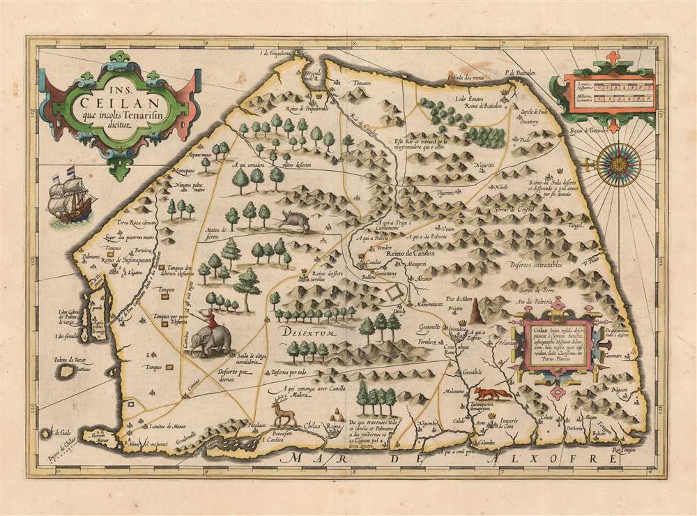
Ins. Ceilan quae incolis Tenarisin dicitur.
1606 (undated) 13.5 x 19.5 in (34.29 x 49.53 cm) 1 : 1000000
1606 (undated) 13.5 x 19.5 in (34.29 x 49.53 cm) 1 : 1000000
Description
This is an attractive edition of the 1606 Jodocus Hondius map of Ceylon of Sri Lanka. As one of the maps introduced to Mercator's Atlas after Hondoius acquired the work, it is among the first maps to address the island from first-hand contemporary reports.
Although the first publication of the present map is predated by a 1605 map derived from Joris Spilbergen's 1601 - 1604 voyage to Sri Lanka, Plancius's work does not appear to have been informed by that voyage and therefore must have preceded it. It is not credible that Plancius would have been ignorant of Spilbergen's voyage. Plancius, as official chartmaker and co-founder of Dutch East India, would have been consulted by fellow co-founder and Dutch merchant Balthazar de Moucheron, who tasked Spilbergen with his voyage to Sri Lanka.
Despite close similarities in the two maps' depictions of the interior and western coastlines, the details pertaining to Spilbergen's landing on the east coast at 'Matecalo' are not evident here, so it is probable that Plancius' map was provided to Hondius prior to the completion Spilbergen's voyage, and reflects the Dutch knowledge of Sri Lanka at the time that Balthazar de Moucheron planned the Dutch effort to establish ties. Also, the map may well have benefited from the reports of Jan van Linschoten, whose Itinerario is cited several times in the descriptive text on the verso.
A Closer Look
This eastern-oriented map presents the island in a schematic yet richly detailed fashion. Its topical detail sets it apart sharply from the Ptolemaic depictions of the island, which dominated earlier cartography. It is a richly decorative piece, with a beautiful compass rose, a fine sailing ship, and an abundance of trees and animals - including an elephant rider, a great fascination for the European reader.Sources
The immediate sources for Hondius' map are credited in the strapwork cartouche in the lower right: Ceilan, the description of which island drawn by the Spanish cosmographer Cyprian Sanchez, was given by the illustrious Petrus Plancius to be included in this work. Sanchez's portolan chart, dating to c. 1560, was informed largely by Portuguese voyages. Plancius' map preserves Spanish descriptive text, as well as the ornate compass rose. The eastern orientation is also derived from Portuguese voyagers, who typically approached the island from the west along the coast. Detail of the map is stronger on the west coast, predominantly, and this also reflects Portuguese contact.Although the first publication of the present map is predated by a 1605 map derived from Joris Spilbergen's 1601 - 1604 voyage to Sri Lanka, Plancius's work does not appear to have been informed by that voyage and therefore must have preceded it. It is not credible that Plancius would have been ignorant of Spilbergen's voyage. Plancius, as official chartmaker and co-founder of Dutch East India, would have been consulted by fellow co-founder and Dutch merchant Balthazar de Moucheron, who tasked Spilbergen with his voyage to Sri Lanka.
Despite close similarities in the two maps' depictions of the interior and western coastlines, the details pertaining to Spilbergen's landing on the east coast at 'Matecalo' are not evident here, so it is probable that Plancius' map was provided to Hondius prior to the completion Spilbergen's voyage, and reflects the Dutch knowledge of Sri Lanka at the time that Balthazar de Moucheron planned the Dutch effort to establish ties. Also, the map may well have benefited from the reports of Jan van Linschoten, whose Itinerario is cited several times in the descriptive text on the verso.
The Riches of Ceylon
Plancius' map contains many notations - in the original Spanish - referring specifically to the political powers on the island, as well as the cinnamon and cardamom to be found there. When Spilbergen met the king of Kandy in 1602, their discussions focused on the spice (cinnamon) trade.Publication History and Census
This map was drawn by Petrus Plancius and engraved by Jodocus Hondius for inclusion in his 1606 edition of Mercator's Atlas. It remained in the Hondius atlases until 1633, at which point it was reengraved. The present example conforms typographically to the examples printed in the Latin edition of Henry Hondius' 1623 Atlas, Edition Quinta. The map is, in its many editions, well represented in institutional collections, and it appears on the market from time to time.CartographerS
Jodocus Hondius (October, 14 1563 - February 12, 1612) was an important Dutch cartographer active in the late 16th and early 17th centuries. His common name, Jodocus Hondius is actually a Latinized version of his Dutch name, Joost de Hondt. He is also sometimes referred to as Jodocus Hondius the Elder to distinguish him from his sons. Hondius was a Flemish artist, engraver, and cartographer. He is best known for his early maps of the New World and Europe, for re-establishing the reputation of the work of Gerard Mercator, and for his portraits of Francis Drake. Hondius was born and raised in Ghent. In his early years he established himself as an engraver, instrument maker and globe maker. In 1584 he moved to London to escape religious difficulties in Flanders. During his stay in England, Hondius was instrumental in publicizing the work of Francis Drake, who had made a circumnavigation of the world in the late 1570s. In particular, in 1589 Hondius produced a now famous map of the cove of New Albion, where Drake briefly established a settlement on the west coast of North America. Hondius' map was based on journal and eyewitness accounts of the trip and has long fueled speculation about the precise location of Drake's landing, which has not yet been firmly established by historians. Hondius is also thought to be the artist of several well-known portraits of Drake that are now in the National Portrait Gallery in London. In 1593, Hondius returned to Amsterdam, where he remained until the end of his life. In 1604, he purchased the plates of Gerard Mercator's Atlas from Mercator's grandson. Mercator's work had languished in comparison to the rival atlas, Theatrum Orbis Terrarum by Ortelius. Hondius republished Mercator's work with 36 additional maps, including several which he himself produced. Despite the addition of his own contributions, Hondius recognizing the prestige of Mercator's name, gave Mercator full credit as the author of the work, listing himself as the publisher. Hondius' new edition of Mercator revived the great cartographer's reputation and was a great success, selling out after a year. Hondius later published a second edition, as well as a pocket version called the Atlas Minor. The maps have since become known as the "Mercator/Hondius series". Between 1605 and 1610 Hondius was employed by John Speed to engrave the plates for Speed's The Theatre of the Empire of Great Britaine. Following Hondius' death in 1612, his publishing work in Amsterdam was continued by his widow and two sons, Jodocus II and Henricus. Later his family formed a partnership with Jan Jansson, whose name appears on the Atlasas co-publisher after 1633. Eventually, starting with the first 1606 edition in Latin, about 50 editions of the Atlas were released in the main European languages. In the Islamic world, the atlas was partially translated by the Turkish scholar Katip Çelebi. The series is sometimes called the 'Mercator/Hondius/Jansson' series because of Jansson's later contributions. Hondius' is also credited with a number of important cartographic innovations including the introduction of decorative map borders and contributions to the evolution of 17th century Dutch wall maps. The work of Hondius was essential to the establishment Amsterdam as the center of cartography in Europe in the 17th century. More by this mapmaker...
Petrus Plancius (1522 - May 15, 1622) was a Dutch-Flemish cartographer, astronomer, and clergyman. Born in Dranouter, he studied theology in Germany and England. He became a minister in the Dutch Reformed Church at the age of 24. In 1585, fearing religious prosecution by the Inquisition after Brussels fell into Spanish hands, Plancius fled to Amsterdam. It was in Amsterdam that he became interested in navigation and cartography and soon became a recognized expert on the shipping routes to India. Plancius published his best known world map in 1592, entitled ‘Nova et exacta Terrarum Tabula geographic et hydrographica’. Plancius was also one of the founders of the Dutch East India Company, for which he drew over 100 maps. Learn More...
Cypriano Sanchez, also Cipriano, also Sanches (15- 16--) was a Spanish or possibly Portuguese cartographer at the end of the sixteenth century. His name is associated with a 1596 manuscript chart of the Atlantic; Petrus Plancius cited him as a source for his map of Sri Lanka, published by Hondius in 1606; the sole printed map associated with Sanchez. Nothing else concrete is known of him. Learn More...
Source
Hondius, H., Atlas, Editio Quinta, (Amsterdam: Hondius) 1623.
Mercator's Atlas is one of the most important works in the history of cartography. Although in fact Ortelius was the first to publish a proper atlas, the Teatrum Orbis Terrarum, Mercator's work the first book to employ the term Atlas for a collection of maps. The term is derived both from the mythical titan, Atlas, who was forced to bear the world upon his shoulders, and the Libyan king, philosopher, and astronomer of the same name that, so the legend goes, constructed the first globe. Mercator dedicated the final 25 years of his life to compile the Atlas. He published two parts during his lifetime in 1585 and 1589, but the final part published posthumously by his son Rumold Mercator, in 1595. The map plates for the Atlas were later acquired by Jodocus Hondius who published the most complete and well known edition in 1606. It was Jodocus who popularized the Atlas and who did the most to elevate Gerard Mercator's name.
Condition
Excellent. Generous borders and a sharp strike.
References
OCLC 1057796533. Rumsey 10501.499. Van der Krogt, P. C. J., Koeman's Atlantes Neerlandici, (Vol. 1), 8380:1A1.