
This item below is out of stock, but another example (left) is available. To view the available item, click "Details."
Details
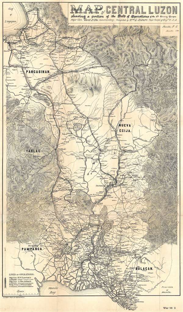
1899 Otis Map of Central Luzon, Philippines, during the Philippine-American War
$850.00
1899 Otis Map of Central Luzon, Philippines, during the Philippine-American War
CentralLuzon-otis-1899$425.00

Title
Map of Central Luzon showing a portion of the Field of Operations of the 8th Army Corps.
1899 (dated) 26 x 15 in (66.04 x 38.1 cm) 1 : 260000
1899 (dated) 26 x 15 in (66.04 x 38.1 cm) 1 : 260000
Description
This is an extremely rare map of central Luzon, the Philippines, issued at the height of the Philippine-American War (1899 – 1902) by William L. Sibert of the 8th Army Engineering Corps and the Military Governor in the Philippines, Major General Elwell Stephen Otis. Drawn on a scale of 1 : 240000, this map is one the most detailed cartographic productions to emerge from the Philippine-American War. The map covers central Luzon, specifically the lands including and just north of Manila and Manila Bay to Lingayen Gulf. During the early stages of the Philippine-American War, this area was largely controlled by Philippine forces and was the most active theater. Three different 'lines of operations' are illustrated, marking the advance of three different columns of troops under the command of Major General Henry Ware Lawton, Major General Arthur MacArthur Jr., and Brigadier General Loyd Wheaton. Numerous cities, towns, and villages are labeled throughout along with rivers and lakes. Roads and telegraph lines are also illustrated. Topography is shown by hachure.
Publication History and Census
This map was prepared by the William L. Sibert, a captain with the 8th Army Engineering Corps, on the order of Major General E. S. Otis, and was printed by A. B. Graham Photo Lithography of Washington, D. C. It appears to be quite scarce, with only one example identified in the OCLC and we know of only one example in a private collection.CartographerS
Andrew B. Graham (1845 - September 9, 1909) was an American lithographer active in Washington, D.C. in late 19th and early 20th century. Graham was born in Washington D.C., the son of a lithographer and engraver. After college, he joined the U.S. Coast Survey, where he was a draftsman until 1889. He retired from the Coast Survey to take over management of his father's lithography firm. The firm, Andrew B. Graham Company, was one of several that thrived on lucrative government publication contracts. Graham died of 'brain fever' in his Washington D. C. residence on September 9 of 1909. Some of his work was republished posthumously until about 1917, and his firm was active until at least the early 1920s. More by this mapmaker...
Elwell Stephen Otis (March 25, 1838 - October 21, 1909) was a United States army officer who served in the American Civil War, Indian Wars, the Philippines late in the Spanish-American War and during the Philippine-American War, where he commanded the Eighth Corps. He served following the Philippine-American War as the Military Governor General of the Philippines. While not popular in the Philippines due to his authoritarian and 'pompous' manner, he was a skilled and capable administrator. Otis was replaced in the Philippines by the more popular Douglas MacArthur in 1900. Otis died in Rochester, New York on October 21, 1909 from painful angina. Learn More...
William Luther Sibert (October 12, 1860 – October 16, 1935) was a American army officer active in several foreign wars. Sibert was born in Gadsden, Alabama, and attended the University of Alabama before entering the United States Military Academy at West Point. Upon graduating he was commissioned into the Army Engineering Corps. During the Philippine-American War (1899-1902) he was appointed Chief Engineer of the 8th Army Engineering Corps, during which he oversaw the compilation of several important maps. During World War I, he was deployed with the first four regiments of the American Expeditionary Force in France. In June of 1918, Sibert was assigned to the War Department's newly created Chemical Warfare Service, which he led until 1920. Following the war Sibert retired from active duty and moved to Bowling Green, Kentucky. As a civilian he engaged in numerous improvement projects in Alabama and on the Hoover Dam. General Sibert is buried at Arlington National Cemetery. He was elected to the University of Alabama Engineering Hall of Fame oi 1961. Learn More...
Condition
Good. Professionally flattened and laid on archival tissue. Some wear and soiling along original fold lines. Even overall toning.
References
OCLC 380832734.