This item has been sold, but you can get on the Waitlist to be notified if another example becomes available, or purchase a digital scan.
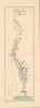
1879 Lombard Map of the Chao Phraya River, Siam (Thailand)
ChaoPhraya-lombard-1879$750.00


Title
Royaume de Siam Cours du fleuve Me-Nam (Mè Năm Chào Phăja).
1879 (dated) 29 x 9 in (73.66 x 22.86 cm) 1 : 740000
1879 (dated) 29 x 9 in (73.66 x 22.86 cm) 1 : 740000
Description
An important 1879 Émile Lombard missionary map of the Chao Phraya River, Thailand (Siam). It is significant as the first major upgrade to Siamese inland cartography since the 1828 John Crawfurd Map (SoutheastAsiaSiam-crawfurdwalker-1828-3). It is the first map to accurately identify towns and villages along the Chao Phraya, and the first we are aware of to use the term 'Chao Phraya'. It is of note that, while in most cases we would emphasize this work as the 'first European mapping' of the region, in this case, indigenous Siamese mapmaking is extremely limited and practically unknown until the 20th century, so this work marks the first time most of these villages appeared in any cartographic context.
A Closer Look
Oriented towards the north, this map follows the main course and portions of several tributaries of the Chao Phraya River, known in contemporary European sources as the Me-Nam. Bangkok sits at bottom with several sites noted, including the French consulate, Catholic churches, canals, and Thai royal palaces. Other cities are indicated with large text, including Phitsanulok at top, Nakhon Sawan at center, and Juthia (Krung Kao, former capital of the Ayutthaya Kingdom, a powerful regional empire with international trading links in the 17th and 18th centuries.) However, this map is most remarkable for the encyclopedic cataloging of large and small villages along the river, areas of elevation, and tributaries, ponds, and other waterways tying in with the Chao Phraya, marked with letters explained in the legend at bottom-left.A Trip Up the Me-Nam
This map is a notable improvement on earlier European maps of the Chao Phraya, especially in its cataloging of villages and other features along the river. Lombard compiled it based on first-hand experience (1878-79) as a missionary traveling on the river. He initially set out with a companion, Father Rousseau, on an informal excursion, as the areas upriver were effectively unknown. Rousseau soon fell ill, but Lombard continued, proselytizing and meeting disparate Christians who had been out of contact with each other or missionaries for ages. Continuing as far as Phitsanulok, he was one of the first Europeans to travel into the interior of Siam offering unique cartographic matieral to the Western geographical community.Publication History and Census
This map was drawn by Émile Lombard soon after completing his trip up the Chao Phraya. It was engraved by Rémy Hausermann, printed by Lemercier, and issued in the 1886 issue of Les Missions catholiques bulletin hebdomadaire de l'Oeuvre de la propagation de la foi. The map is only independently cataloged among the holdings of the Bibliothèque nationale de France, Université Bordeaux Montaigne, Staatsbibliothek zu Berlin, and Universiteit Antwerpen.CartographerS
Émile Lombard (1849 - 1883) was a French missionary active in Siam (Thailand) during his brief missionary career. He was born in Bénévent-et-Charbillac, in the French Alps, and in 1868 entered the seminary of the Missions Etrangères de Paris. After training, he left for Siam in 1873. After managing a parish in Bangkok for two years, he began to teach at the seminary there before, in 1878-79, making a journey up the Chao Phraya River to Phitsanulok, meeting scattered communities along the way. Afterwards, he drew a map of the river and its villages, itself a significant advancement on existing European maps of the region. He died shortly afterwards, in 1883, in Bangkok, likely of malaria. More by this mapmaker...
Rose-Joseph Lemercier (June 29, 1803 - 1887) was a French photographer, lithographer, and printer. One of the most important Parisian lithographers of the 19th century, Lemercier was born in Paris into a family of seventeen children. His father was a basket maker, and he even began working as a basket maker at the age of fifteen, but Lemercier was drawn to lithography and printing and soon entered into an apprenticeship with Langlumé, where he worked from 1822 until 1825. After working for a handful of other printers, Lemercier started his own firm in 1828 at 2, rue Pierre Sarrazin with only one printing press. He subsequently moved a few more times before arriving at 57, rue de Seine, where he founded the printing firm Lemercier and Company. He created the firm Lemercier, Bénard and Company in 1837 with Jean François Bénard. Lemercier bought out Bénard's share in the firm in 1843 and, since his two sons died at a young age, he decided to bring his nephew Alfred into the business beginning in 1862, who would progressively take on more and more responsibility in running the firm. Between 1850 and 1870, Lemercier's firm was the largest lithographic company in Paris. The firm began to decline in prestige in the early 1870s, and, after Lemercier's death in 1887, its descent only quickened. It is unclear when the firm closed, but Alfred directed the firm until his death in 1901. Learn More...
Rémy Hausermann (1843 - 1933) was a French map engraver who, among other roles, was the main engraver for the Missions Catholiques de Lyon, allowing him to introduce the geography of areas previously little known or unknown to a European audience. Little is known about his early life and training, but by 1879 he was the Vice President of the Congrès des Sciences géographiques. He was well-known and well-regarded in geographical study circles in the late 19th century, writing school textbooks on the subject and receiving accolades at the 1878 exposition universelle in Paris. Learn More...
Source
L'Oeuvre pontificale de la propagation de la foi, Les Missions catholiques bulletin hebdomadaire de l'Oeuvre de la propagation de la foi, (Paris et Lyon) 1886.
Condition
Very good. Light wear on original folds. Centerfold repaired on verso.
References
OCLC 904998067, 902292555, 1244528846.