
This item below is out of stock, but another example (left) is available. To view the available item, click "Details."
Details
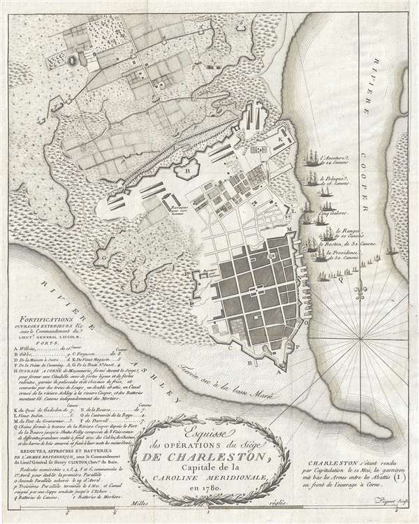
1787 Picquet Map of Charleston illustrating the Siege of Charleston
1787 (undated) $1,750.00
1787 Picquet Map of Charleston illustrating the Siege of Charleston
Charleston-picquet-1787$875.00

Title
Esquisse des Opérations du Siège de Charleston, Capitale de la Caroline Méridionale, en 1780.
1787 (undated) 14.25 x 11.5 in (36.195 x 29.21 cm) 1 : 12000
1787 (undated) 14.25 x 11.5 in (36.195 x 29.21 cm) 1 : 12000
Description
An excellent highly detailed 1787 American Revolutionary War map of Charleston, South Carolina. Illustrating the 1780 Siege of Charleston, a major American Revolutionary War battle, the map covers the peninsular tip of Charleston and predates many of the landfills and expansions that followed as the city developed. The port is evident as is the early grid structure. The Circular Congregational Church, which still stands and was built in 1695, is recognizable. Swampland is mapped to the west of the city and farmland appears just north of the city fortifications.
The Siege of Charleston took place from April 1st to May 12th, 1780, late in the war when British forces, suffering setbacks in the northeastern colonies, instead decided focus on winning the south. Over some six weeks, the British under the command of General Sir Henry Clinton, outmaneuvered the Continental defenders led by General Benjamin Lincoln. The resulting Continental defeat and surrender was the Revolutionary War's greatest single troop loss. Detailed letter keys identify both American and British fortifications. The blockading British fleet, comprising 9 ships each of which is named, appears in the Cooper River.
This map was issued to accompany the 1787 first French edition of David Ramsay's (1747-1815) History of the Revolution of South-Carolina or, more properly, Histoire de la Revolution d'Amerique par rapport a la Caroline Meridionale. The French edition of Ramsay's history was issued 2 years after the English edition. The map, which was originally engraved by the Charleston engraver Thomas Abernethie, has here been re-engraved in French by Charles Picquet. While cartographically similar, Piquet's engraving is more sophisticated and refined. This is one of the earliest obtainable maps of Charleston and is rare on the market.
Cartographer
Charles Picquet (April 15, 1771 – January 15, 1827) was a French cartographer active in Paris during the Napoleonic and post-Napoleonic Eras. Picquet was born in Romagna-sous-Montfaucon, Meuse, France. From about 1798 Picquet supplied maps to the Dépôt de la Guerre. From 1806 he was appointed to Napoleon's Cabinet Topographique. Being politically dexterous, he was able to retain this position after the fall of Napoleon under both Louis XVIII and Charles X. Under Louis XVIII he also obtained the Brevet de Géographe Ordinaire du Cabinet Topographique. He worked with the cartographer Adrien-Hubert Brué on a major atlas project. When Charles Picquet died in 1827, his son, Pierre-Jacques Picquet, continued to publish under his father's imprint name well into the middle part of the 19th century. More by this mapmaker...
Source
Ramsay, D., Histoire de la Revolution d'Amerique par rapport a la Caroline Meridionale, (Paris) 1787.
Condition
Very good. Upper right margin extended.
References
OCLC 494256020. Nebenzahl (Biblio) #84.