1868 Eldridge Nautical Chart or Map of the Chesapeake Bay
ChesapeakeBay-eldridge-1868$1,800.00


Title
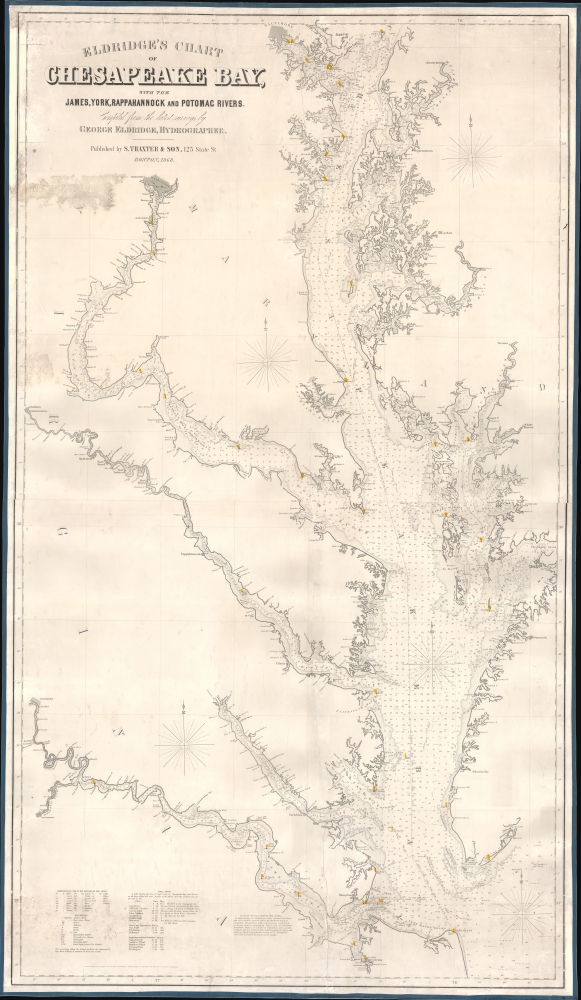
Eldridge's Chart of Chesapeake Bay, with the James, York, Rappahannock and Potomac Rivers.
1868 (dated) 57.25 x 33 in (145.415 x 83.82 cm) 1 : 246000
1868 (dated) 57.25 x 33 in (145.415 x 83.82 cm) 1 : 246000
Description
A rare first edition 1868 Eldridge / Thaxter nautical chart or maritime map of the Chesapeake Bay. This expansive chart covers the Chesapeake from its mouth at Cape Henry to Baltimore. It extends westward to include the James, York, Rappahannock, and Potomac River estuaries. In a brilliant aesthetic flourish, Washington D.C. appears centered directly below the title area, with the President's House, the Capitol, and the Smithsonian Institution labeled. Includes original hand color highlighting of lighthouses.
Eldridge Charts
According to Guthorn,Although based upon the official Coast Surveys, the Eldridge charts were unsubsidized and more expensive. They survived because of good design, simplicity, omission of extraneous shore topography, legible sounding and notes, and the use of compass courses only.… Their loyal public, fishermen, coaster, tug masters, and yachtsmen, often continued to use obsolete Eldridge charts until the beginning of World War II. (Guthorn, U. S. Coastal Charts, p. 12.)
Blueback Charts
Blueback nautical charts began appearing in London in the late 18th century. Bluebacks, as they came to be called, were privately published large format nautical charts known for their distinctive blue paper backing. The backing, a commonly available blue manila paper traditionally used by publishers to wrap unbound pamphlets, was adopted as a practical way to reinforce the low-quality paper used by private chart publishers in an effort to cut costs. That being said, not all blueback charts are literally backed with blue paper. The earliest known blueback charts include a 1760 chart issued by Mount and Page, and a 1787 chart issued by Robert Sayer. The tradition took off in the early 19th century, when British publishers like John Hamilton Moore, Robert Blachford, James Imray, William Heather, John William Norie, Charles Wilson, David Steel, R. H. Laurie, and John Hobbs, among others, rose to dominate the chart trade. Bluebacks became so popular that the convention was embraced by chartmakers outside of England, including Americans Edmund March Blunt and George Eldridge, as well as Scandinavian, French, German, Russian, and Spanish chartmakers. Blueback charts remained popular until the late 19th century, when government subsidized organizations like the British Admiralty Hydrographic Office and the United States Coast Survey, began issuing their own superior charts on high quality paper that did not require reinforcement.Publication History and Census
Eldridge first issued this chart in 1868 (present example) in partnership with Samuel Thaxter Cushing. It was published and printed by Samuel Thaxter, who also served as Eldridge's sales agent. The chart was one of Eldridge's most popular and went through multiple updates. We are aware of subsequent issues in 1870, 1872, 1874, 1878, 1879, 1882, 1883, and 1895.CartographerS
George Eldridge (November 27, 1821 - August 23, 1900) and his son George Washington Eldridge (1845 - 1914) were American makers of nautical charts and Pilot Books active in the late 19th century. George Eldridge was a Cape Cod fisherman known locally as an excellent ship's pilot. While recuperating from an injury in 1851, Eldridge drew his first nautical chart. The chart proved popular, and its success led Eldridge to pursue a career in hydrography - the science of mapping the sea with a special focus on navigation. Eldridge produced numerous subsequent maps and is credited with issuing some of the earliest accurate nautical charts of the American Atlantic coast. In time George Eldridge passed his thriving business on to his son, George Washington Eldridge, who continued to produce beautiful and practical maritime charts until 1924.Though most of Eldridge's charts were loosely based on U.S. Coast Survey work, they proved popular with navigators. The Eldridges possessed a talent, shared by both father and son, for distilling the often convoluted Coast Survey maps into practical nautical charts for the working mariner. From 1875, in addition to large format independently issued nautical charts, Eldridge also issued annual editions of Eldridge's Tide and Pilot Book and The Book of Harbor Charts. The Eldridge offices were located at 103 State St. Boston, Massachusetts. After the deaths of George and George Washington Eldridge, the firm passed into the hands of the latter's widow Sydna, and son-in-law, Wilfrid O. Wight. Wight's son and subsequent generations have continued to publish the Eldridge Tide and Pilot Book down to the present. More by this mapmaker...
Samuel Thaxter and Son (fl. 1792 - 1916). Samuel Thaxter (1769 - 1842) is the founder of a Boston dynasty of manufacturers of mathematical instruments and nautical charts. He founded the firm in 1792 and is first referenced in the 1796 Boston Directory. Around 1822 he incorporated his son, Joseph H. Thaxter (1801 - 1835), into the business renaming it 'Samuel Thaxter and Son'. The firm would retain this name for the remainder of its existence. This successful business was subsequently passed to Joseph H. Thaxter's son, Samuel Thaxter Cushing (1821 - 1882), in 1843. It was Thaxter Cushing who developed the firm's publishing arm, partnering with the Boston nautical chart maker George Eldridge. They are best known for 13 large format blueback charts focusing on the east cost of the United States published in the second half of the 19th century. They also published numerous smaller maps and pilot books. After Thaxter Cushing died the firm was taken over by his widow, Abby C. Cushing, who managed it until 1905. It was subsequently managed by Herbert Risteen Starratt and continued to be registered in the Boston Directory until about 1916. Learn More...
Condition
Very good. Full professional restoration. Original 'blue' backing replaced with linen for stability. Some scuffing. Closed tear extending thirty-three-and-one-half (33.5) inches into printed area from bottom margin professionally repaired on verso. Two closed tears extending eleven (11) inches into printed area from top margin professionally repaired on verso. Edged in beautiful blue silk.
References
OCLC 649718496. Phillips (America), p. 228 (1868 ed.).