This item has been sold, but you can get on the Waitlist to be notified if another example becomes available, or purchase a digital scan.
1860 U.S. Coast Survey Map of the Chesapeake Bay and Delaware Bay
ChesapeakeBay-uscs-1860$300.00

Title
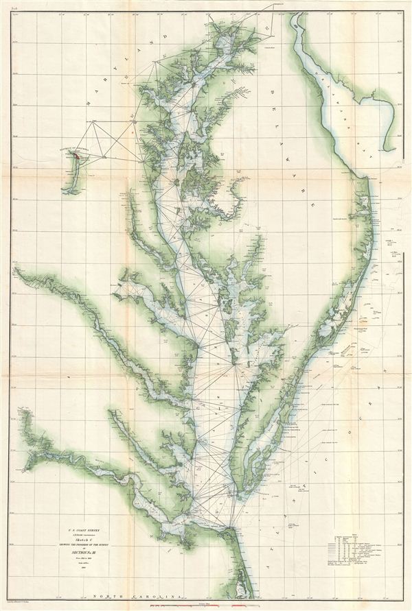
Sketch C Showing the Progress of the Survey in Section No. III From 1842 to 1860.
1860 (dated) 31.5 x 25 in (80.01 x 63.5 cm) 1 : 400000
1860 (dated) 31.5 x 25 in (80.01 x 63.5 cm) 1 : 400000
Description
This is an exceptional example of the 1860 U.S. Coast Survey's progress chart of the Chesapeake Bay. The map covers from the mouth of the Susquehanna River southwards as far as Cape Henry and Norfolk. This chart includes both the Chesapeake Bay and Delaware Bay in full, as well as small portions of the Potomac River, Rappahannock River, York River, James River, Patapsco River, and Patuxent River. Washington D.C., Cape May, Charleston, Baltimore, Annapolis, Chestertown, Easton, Cambridge and Norfolk, are identified. Triangulation points are noted throughout the region as well as all major islands, rivers, and inlets. This map was issued in the years just prior to the American Civil War (1861 - 1865) when the Chesapeake Bay area would become one of the most active theaters. The work of the U.S. Coast Survey, nearly to a man dedicated Union supporters, played a significant role in the superior Union Navy's ability to control the American coastlines, thereby limiting troop movements and strangling Confederate supply lines. To Prepared under the supervision of A. D. Bache 1860 Superintendent's Report.
Cartographer
The Office of the Coast Survey (1807 - present) founded in 1807 by President Thomas Jefferson and Secretary of Commerce Albert Gallatin, is the oldest scientific organization in the U.S. Federal Government. Jefferson created the "Survey of the Coast," as it was then called, in response to a need for accurate navigational charts of the new nation's coasts and harbors. The spirit of the Coast Survey was defined by its first two superintendents. The first superintendent of the Coast Survey was Swiss immigrant and West Point mathematics professor Ferdinand Hassler. Under the direction of Hassler, from 1816 to 1843, the ideological and scientific foundations for the Coast Survey were established. These included using the most advanced techniques and most sophisticated equipment as well as an unstinting attention to detail. Hassler devised a labor intensive triangulation system whereby the entire coast was divided into a series of enormous triangles. These were in turn subdivided into smaller triangulation units that were then individually surveyed. Employing this exacting technique on such a massive scale had never before been attempted. Consequently, Hassler and the Coast Survey under him developed a reputation for uncompromising dedication to the principles of accuracy and excellence. Unfortunately, despite being a masterful surveyor, Hassler was abrasive and politically unpopular, twice losing congressional funding for the Coast Survey. Nonetheless, Hassler led the Coast Survey until his death in 1843, at which time Alexander Dallas Bache, a great-grandson of Benjamin Franklin, took the helm. Bache was fully dedicated to the principles established by Hassler, but proved more politically astute and successfully lobbied Congress to liberally fund the endeavor. Under the leadership of A. D. Bache, the Coast Survey completed its most important work. Moreover, during his long tenure with the Coast Survey, from 1843 to 1865, Bache was a steadfast advocate of American science and navigation and in fact founded the American Academy of Sciences. Bache was succeeded by Benjamin Pierce who ran the Survey from 1867 to 1874. Pierce was in turn succeeded by Carlile Pollock Patterson who was Superintendent from 1874 to 1881. In 1878, under Patterson's superintendence, the U.S. Coast Survey was reorganized as the U.S. Coast and Geodetic Survey (C & GS) to accommodate topographic as well as nautical surveys. Today the Coast Survey is part of the National Oceanic and Atmospheric Administration or NOAA as the National Geodetic Survey. More by this mapmaker...
Source
Bache, A. D., Report of the Superintendent of the United States Coast Survey, (Washington) 1860.
Condition
Very good condition. Slight toning and wear on original fold lines - especially at fold intersections. Backed on archival tissue for stability.
References
Swem, E. G., Maps Relating to Virginia, no. 1212.