This item has been sold, but you can get on the Waitlist to be notified if another example becomes available, or purchase a digital scan.
1857 U. S. Coast Survey Map of the Chesapeake Bay (3 parts)
ChesapeakeBay3part2-uscs-1857$875.00

Title
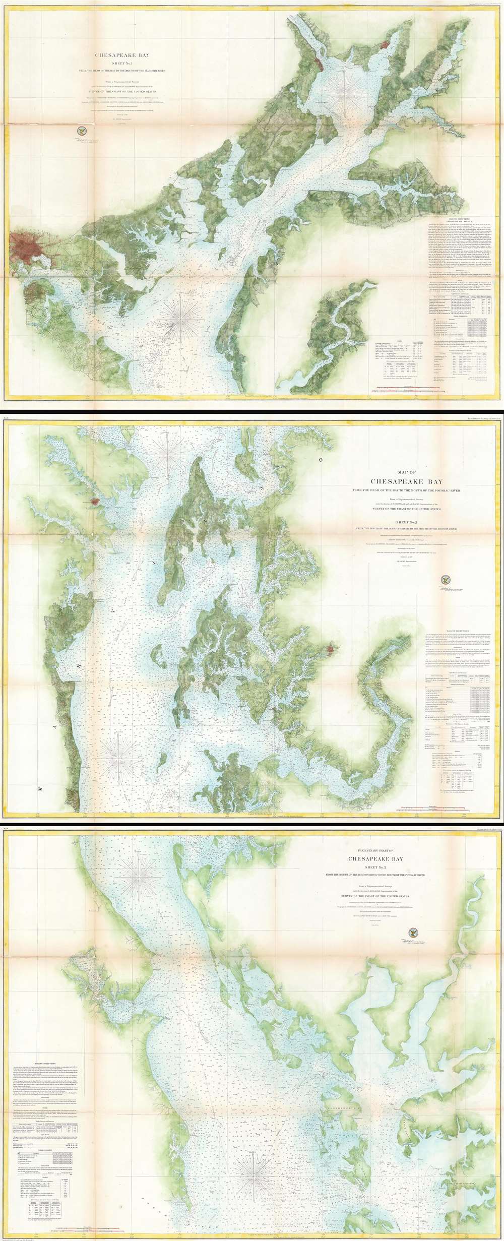
Chesapeake Bay Sheet No. 1 From the Head of the Bay to the Mounth of the Magothy River. - Chesapeake Bay From the Head of the Bay to the Mouth of the Potomac River. Sheet No. 2 From the Mouth of the Magothy River to the Mouth of the Hudson River. - Preliminary Chart of Chesapeake Bay Sheet No. 3 From the Mouth of the Hudson River to the Mouth of the Potomac River.
1857 (dated) 93 x 38 in (236.22 x 96.52 cm) 1 : 80000
1857 (dated) 93 x 38 in (236.22 x 96.52 cm) 1 : 80000
Description
This is a monumental and rarely available three-part 1857 nautical chart or maritime map of the Chesapeake Bay. Prepared for the 1857 edition of the U.S. Coast Survey's Superintendent's Report this giant map depicts the Chesapeake Bay from the head of the bay and the mouth of the Susquehanna River south to the mouth of the Potomac River. The top or first chart covers from the head of the bay to the mouth of the Magothy River, inclusive of the Patapsco River and the city of Baltimore – which is detailed to street level. The second or middle chart covers from the Magothy River to the mouth of the Hudson River and includes Annapolis, Cambridge, and Easton. This second chart also bears the title of the three-map series in addition to its individual title. The bottom or third chart in this series covers from the mouth of the Little Choptank River River to the mouth of the Potomac River.
Mapping the Chesapeake
The United States Coast Survey considered the construction of a detailed map of the Chesapeake Bay to be one of its top priorities. Various commands under Blunt, Maffit, Cutts, Hassler, Lee, Nelson, Gerdes, and others contributed extensive data to the multi-year effort. Careful observers will note that the upper sheets seem darker than the lower sheets. In the effort to map this region, the northern extremes of the Chesapeake Bay, long considered the most dangerous and poorly charted, where given precedence. Thus does a density of data, including countless depth soundings, topographical data, and sailing instructions, give evidence to the stately progress of the survey in the Chesapeake Bay.Publication History and Census
Each sheet from this series measures some 30 x 37 inches for an overall dimension of roughly 93 x 38 inches. Though these maps do occasionally appear individually they are rarely available as a set. The maps were created under the supervision of A. D. Bache, one of the most active and influential Superintendents of the U.S. Coast Survey and published in the Report of the Superintendent of the United States Coast Survey in 1857.CartographerS
The Office of the Coast Survey (1807 - present) founded in 1807 by President Thomas Jefferson and Secretary of Commerce Albert Gallatin, is the oldest scientific organization in the U.S. Federal Government. Jefferson created the "Survey of the Coast," as it was then called, in response to a need for accurate navigational charts of the new nation's coasts and harbors. The spirit of the Coast Survey was defined by its first two superintendents. The first superintendent of the Coast Survey was Swiss immigrant and West Point mathematics professor Ferdinand Hassler. Under the direction of Hassler, from 1816 to 1843, the ideological and scientific foundations for the Coast Survey were established. These included using the most advanced techniques and most sophisticated equipment as well as an unstinting attention to detail. Hassler devised a labor intensive triangulation system whereby the entire coast was divided into a series of enormous triangles. These were in turn subdivided into smaller triangulation units that were then individually surveyed. Employing this exacting technique on such a massive scale had never before been attempted. Consequently, Hassler and the Coast Survey under him developed a reputation for uncompromising dedication to the principles of accuracy and excellence. Unfortunately, despite being a masterful surveyor, Hassler was abrasive and politically unpopular, twice losing congressional funding for the Coast Survey. Nonetheless, Hassler led the Coast Survey until his death in 1843, at which time Alexander Dallas Bache, a great-grandson of Benjamin Franklin, took the helm. Bache was fully dedicated to the principles established by Hassler, but proved more politically astute and successfully lobbied Congress to liberally fund the endeavor. Under the leadership of A. D. Bache, the Coast Survey completed its most important work. Moreover, during his long tenure with the Coast Survey, from 1843 to 1865, Bache was a steadfast advocate of American science and navigation and in fact founded the American Academy of Sciences. Bache was succeeded by Benjamin Pierce who ran the Survey from 1867 to 1874. Pierce was in turn succeeded by Carlile Pollock Patterson who was Superintendent from 1874 to 1881. In 1878, under Patterson's superintendence, the U.S. Coast Survey was reorganized as the U.S. Coast and Geodetic Survey (C & GS) to accommodate topographic as well as nautical surveys. Today the Coast Survey is part of the National Oceanic and Atmospheric Administration or NOAA as the National Geodetic Survey. More by this mapmaker...
Alexander Dallas Bache (July 19, 1806 - February 17, 1867) was an American physicist, scientist and surveyor. Bache is best known in cartographic circles as the Superintendent of the U.S. Coast Survey from 1843 to 1865. Born in Philadelphia, Bache, a great grandson of the statesman and inventor Benjamin Franklin, had a varied career primarily focused on education. He toured Europe on behalf of Girard College and composed an important treatise on European Education. Later he served as president of Philadelphia's Central High School and was a professor of natural history and chemistry at the University of Pennsylvania. On the death of Ferdinand Rudolph Hassler, Bache was appointed Superintendent of the United States Coast Survey. Picking up where Hassler left off Bache presided over the Survey during its most prolific period and oversaw the mapping of most of the United States coastline. To this day his name appears on countless marine pilot books and U.S. Coast Survey nautical charts. For his work he was elected Associate Fellow of the American Academy of Arts and Sciences, a Fellow of the Royal Society of Edinburgh, and a Foreign Member of the Royal Society. Following the Civil War, Bache was elected a 3rd Class Companion of the Military Order of the Loyal Legion of the United States. He died at Newport, Rhode Island and was buried in the Congressional Cemetery in Washington, DC, where he is commemorated with a monument built by American architect Henry Hobson Richardson. Learn More...
Source
Bache, A.D., Report of the Superintendant of the United States Coast Survey, (Washington) 1857.
Condition
Good. Three sheets. Each sheet backed on archival tissue for stability. Varying degrees of wear and toning evident on each sheet. Areas of infill along fold lines and at fold intersections on each sheet. Close left and right margin on Sheet No. 3. Each sheet is blank on verso.