This item has been sold, but you can get on the Waitlist to be notified if another example becomes available.
1957 Davis Pictorial Map of Chesterfield County, Virginia
ChesterfieldCounty-davis-1957$475.00

Title
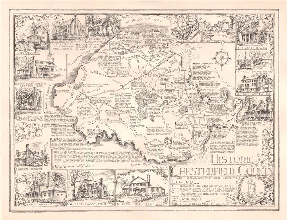
Historic Chesterfield County.
1957 (undated) 19 x 24.5 in (48.26 x 62.23 cm)
1957 (undated) 19 x 24.5 in (48.26 x 62.23 cm)
Description
This is a signed 1957 Bernard W. Davis pictorial map of Chesterfield County, Virginia. The map depicts the region between Richmond and Petersburg, Virginia, which witnessed the end of the American Civil War (1861 - 1865). Davis places great emphasis on the Civil War and refers to it as the 'War Between the States' at least once. Black arrows trace the retreat of Generals Longstreet, Gordon, and Robert E. Lee from Petersburg following their defeat by Grant. Other arrows illustrate the retreat of Generals Ewell, Custus, and Lee from Richmond, as well as the flight of Jefferson Davis and his cabinet.
An Historical Map
Per Davis, he created this piece 'as an historical map' and he filled it will historical information about the county covering from 1600 until the late 19th century. There are even a few notes dating to the early 20th century. Short annotations describe historic buildings and their significance, American Civil War battles, and stories of the county's coal mines. Fifteen views create a pictorial border and illustrate historic buildings. Each view is labeled and numbered, corresponding with a number on the map marking the building's location. Only major roads are illustrated and, per Davis, 'those roads indicated are shown only if they lead to historical points of interest shown on the map or if their indication is necessary to orient those unfamiliar with the county'. Likewise, only railroads in operation during the Civil War are illustrated.Publication History and Census
This map was created by Bernard W. Davis, lithographed by the Everett Waddey Company, and published in 1957. The present example is signed by Davis and numbered 9 of 600, suggesting that only 600 of these were published. An example is cataloged in OCLC and is part of the collection at the University of Virginia. Per the OCLC, that example was donated by Davis himself in July 1957.CartographerS
Bernard Woodrow Davis (February 14, 1919 - February 19, 1968) was an American artist and educator. Born in Richmond, Virginia, Davis attended the University of Virginia. He served as a technical sergeant during World War II with the 335th Engineers and was a draftsman before he entered the army. He was at Pearl Harbor when the Japanese attacked and served in Europe. After the war, Davis taught art Manchester High School in Manchester, Virginia. He was appointed Chesterfield County's first building inspector in 1950 and held the position for two years before resigning. He married Frieda Goode Jackson on May 12, 1942, with whom he had a son and a daughter. More by this mapmaker...
The Everett Waddey Company (1872 - Present) was founded in 1872 by Everett Waddey (March 25, 1853 - January 14, 1908). The company, based in Richmond, Virginia, grew into a major East Coast printing firm and employed hundreds of people in Richmond. Bob DeLille bought the company in 1995 and renamed it Creative. Learn More...
Condition
Very good. Exhibits minor damp staining in bottom margin not effecting the printed area.
References
OCLC 463594767.