This item has been sold, but you can get on the Waitlist to be notified if another example becomes available, or purchase a digital scan.
1949 War Office Survey Map of Cheung Chau, Shek Kwu Islands, Hong Kong
CheungChauHK-waroffice-1949$250.00


Title
Hong Kong and the New Territories. Cheung Chau Island.
1949 (dated) 25.25 x 34.5 in (64.135 x 87.63 cm) 1 : 20000
1949 (dated) 25.25 x 34.5 in (64.135 x 87.63 cm) 1 : 20000
Description
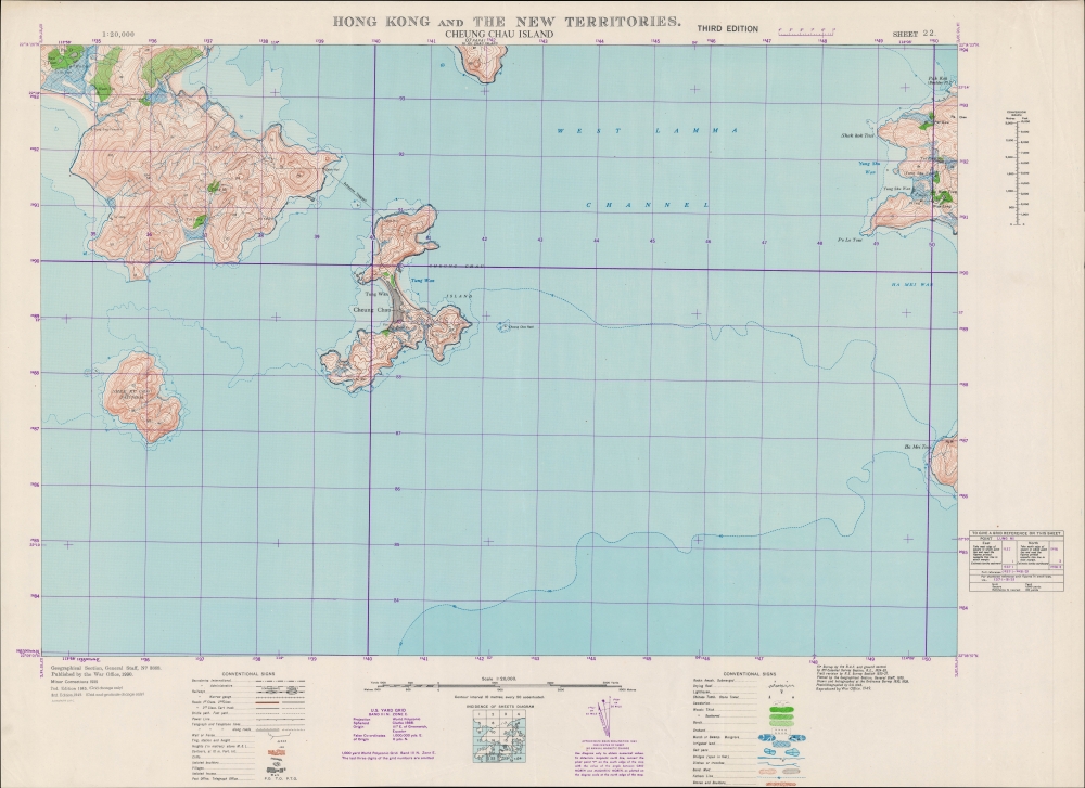
An impressive large-format 1949 War Office map of Cheung Chau Islands and environs, part of the New Territories of Hong Kong.
Lantau Island, the southeastern portion of which is included here, also was characterized by sporadic fishing villages in pre-British times, but in recent years has been known as the home of Hong Kong Disneyland and (like Lamma Island) as a refuge for Hong Kongers fed up with the urban rat race. The area seen here, though, has been mostly protected as parkland and remains undeveloped.
The United Kingdom was the earliest Western power to recognize the People's Republic of China, in January 1950, in a bid to protect Hong Kong. Still, it was not at all clear that Hong Kong would be safe from a Communist invasion, and Britain was hardly in a position to try to defend the colony at the time. We now know that part of the reason the Communists left Hong Kong alone is because it served a vital function as a window to the capitalist world, allowing, for instance, the evasion of a U.S. blockade to receive critical supplies during the Korean War. Though tens of thousands of refugees fled the mainland for Hong Kong in the late 1940s, the border between Hong Kong and 'red' China was quite open in the early-mid 1950s, allowing Hong Kong residents to travel to their home villages and visit relatives. Though this 'travel,' often an excuse for trading, was a thorn in the side of the Communists, who were attempting to institute a strict customs regime and control the flow of precious metals to support the renminbi, it also was an economic boon, especially to Guangdong and Fujian provinces.
A Closer Look
Coverage includes Cheung Chau, Shek Kwu, and portions of Lantau, Hei Ling, and Lamma Islands. These islands and waters lie to the southwest of Hong Kong Island. Information is indicated at a granular level of detail, down to individual orchards and irrigated fields, power lines, fences, and footpaths. Though not a chart per se, fathoms, hazards, reefs, and other maritime features are also noted. The purple grid overlying the map corresponds to a World Polyconic Projection using the U.S. Yard Grid system, developed for the 'Southwest Pacific' region during World War II by modifying a pre-existing British grid system.The Islands
Historically, Cheung Chau has been a fishing village, even in the days prior to the British presence on Hong Kong Island, and it was only incorporated into the British colony when the New Territories were added in 1898. At right is a portion of Lamma Island, the name of which is notable for being a transliteration of a Portuguese name for the island that was then misinterpreted by Alexander Dalrymple on an early English chart of the area, rather than an English transliteration of a Cantonese name, as is standard for placenames in Hong Kong. Shek Kwu or Shek Wu was uninhabited at the time this map was produced; in subsequent decades, it has been used as a rehabilitation site for drug addicts.Lantau Island, the southeastern portion of which is included here, also was characterized by sporadic fishing villages in pre-British times, but in recent years has been known as the home of Hong Kong Disneyland and (like Lamma Island) as a refuge for Hong Kongers fed up with the urban rat race. The area seen here, though, has been mostly protected as parkland and remains undeveloped.
Historical Context
This map was one part of a 24-sheet survey map series of Hong Kong, first undertaken in 1929 - 1930 and updated periodically thereafter. This ambitious undertaking was no doubt one of the largest, if not the largest, topographical surveys of Hong Kong at the time. The updates made after the Second World War (2nd and 3rd editions) were no doubt motivated by taking stock after the city's occupation by the Japanese. But the third edition in 1949 also coincides with the Communist revolution in mainland China, which presented a serious threat to the colony.The United Kingdom was the earliest Western power to recognize the People's Republic of China, in January 1950, in a bid to protect Hong Kong. Still, it was not at all clear that Hong Kong would be safe from a Communist invasion, and Britain was hardly in a position to try to defend the colony at the time. We now know that part of the reason the Communists left Hong Kong alone is because it served a vital function as a window to the capitalist world, allowing, for instance, the evasion of a U.S. blockade to receive critical supplies during the Korean War. Though tens of thousands of refugees fled the mainland for Hong Kong in the late 1940s, the border between Hong Kong and 'red' China was quite open in the early-mid 1950s, allowing Hong Kong residents to travel to their home villages and visit relatives. Though this 'travel,' often an excuse for trading, was a thorn in the side of the Communists, who were attempting to institute a strict customs regime and control the flow of precious metals to support the renminbi, it also was an economic boon, especially to Guangdong and Fujian provinces.
Publication History and Census
This map was initially produced by the British War Office in 1930 incorporating air surveys undertaken by the Royal Air Force and Royal Engineers. It was updated in 1945 and this third edition appeared in 1949, with assistance from the Ordnance Survey (subsequent editions were produced in 1952, 1957, and 1969). This is the 22nd Sheet in a series of 24 (a diagram of the full survey is included at bottom-center). It appears in the collections of about 20 institutions worldwide, though the complexities of dating the map make establishing a precise census difficult, and it is unclear if any institution holds this edition of the map. The National Library of Australia holds the entire series, but with individual maps from different editions which are not clearly indicated in the catalog listing.CartographerS
The British War Office (1857 - 1964) was a department of the British Government responsible for the administration of the Royal Army until 1964, when its functions were transferred to the Ministry of Defense. The War Office was to the Royal Army what the Admiralty was to the Royal Navy, and later, the Air Ministry. Within the War Office, the General Staff Topographical Section was responsible for thousands of maps issued for British intelligence and military use. The Topographical Section was renamed Geographical Section in April 1907. Many, once their military use passed, were offered through licensed agents to the general public. The sole London agent for War Office material was Edward Stanford. More by this mapmaker...
The British Ordnance Survey (1791 - present) is the national mapping agency of Great Britain and is one of the largest producers of maps in the world. This non-ministerial department of the government of the United Kingdom is responsible for producing maps of Great Britain and many of its overseas possessions. The history of the Ordnance Survey goes back as far as 1747, following the Jacobite rising, when King George II commissioned a comprehensive military survey of Scotland to assist further campaigns. The result, produced by Paul Sandby, John Mason and William Roy, was the Duke of Cumberland's Map, the first military quality map of the British Isles. This grew into the Principal Triangulation of Great Britain (1783-1853) under William Roy, and eventually lead to the creation of the Ordnance Survey in 1791. Today the Ordnance Survey produces a large variety of paper maps and digital mapping products. Its large scale maps, issued to the scale of 1:10000, available in sheet map form until the 1980s, are now only available digitally. All maps produced by the Ordnance Survey are in copyright for 50 years after publication. Learn More...
Condition
Very good.