This item has been sold, but you can get on the Waitlist to be notified if another example becomes available, or purchase a digital scan.
1909 Blanchard / Cram Folding Map of Chicago
Chicago-blanchard-1909$300.00


Title
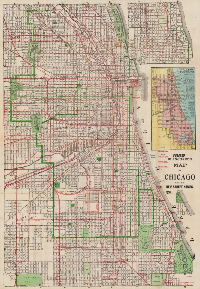
Blanchard's map of Chicago with new street names, steam railroads, street car lines, street numbers and sections.
1909 (dated) 35.75 x 24 in (90.805 x 60.96 cm) 1 : 20500
1909 (dated) 35.75 x 24 in (90.805 x 60.96 cm) 1 : 20500
Description
A large 1909 folding map of Chicago published by Rufus Blanchard and George F. Cram. Among other features, it highlights the renumbering of the city's streets that began the year of publication.
A Closer Look
Roads, transportation lines, major public institutions, and parks are noted throughout. Two insets depict the coastline north and south of the city beyond the scope of the main map. As indicated to the left of the title, the jagged lines represent elevated trains (the 'L'), and dashed lines represent streetcar lines. The city's impressive railway network is also marked, leading to the Union Stock Yards, at center towards bottom, freight depots, or one of several passenger terminals: the Grand Central Depot, Dearborn Station, the Rock Island Depot (LaSalle Street Station), the Illinois Central Depot (Central Station), Union Depot, and the Nickel Plate Depot. Except for Union Station, these were all at least partially demolished in the 1970s and 1980s.New Street Names
The 'new street names' referred to in the title and highlighted in the inset map relate to the systematic renaming of Chicago's streets in 1909 - 1911. Although Chicago's street names had been partially regulated in 1871, some street names were repeated in different parts of the city, some streets changed names seemingly randomly along their course, and some streets had multiple informal names. To rationalize both streets and addresses, the city passed an ordinance that beginning on September 1, 1909, a new system of numbering would go into effect whereby State Street would divide western and eastern sections of streets, and Madison Street would divide northern and southern sections of streets. One hundred house numbers or addresses were assigned to each one-eighth portion of a street, as indicated in the inset map above the title.Publication History and Census
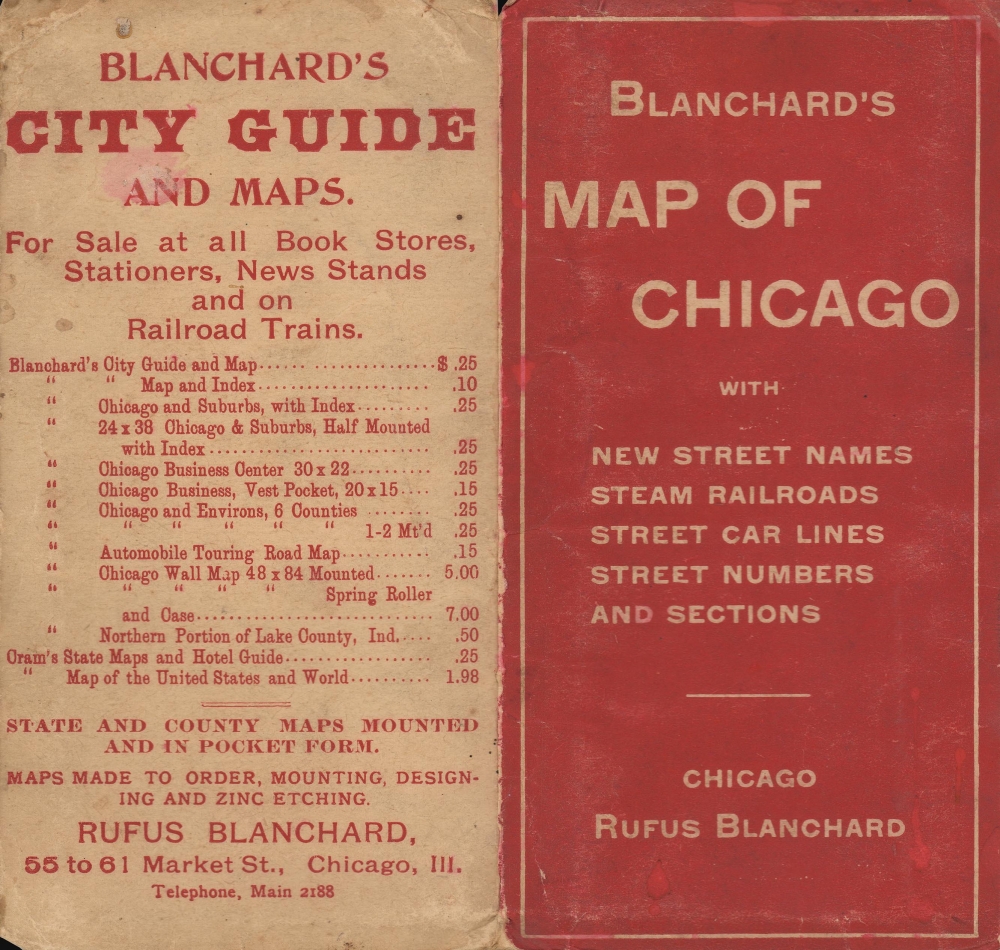
This map was published in 1909 by the firm of Rufus Blanchard, who had died five years prior, while the copyright of George F. Cram can be seen in the inset map above the title. It should not be confused with the similar 1909 'Blanchard's map of Chicago and suburbs: showing wards, congressional and senatorial districts,' which also lists George F. Cram as the publisher. Cram was Blanchard's nephew, and the two co-owned a map publishing house that was destroyed in the 1871 Great Chicago Fire. Afterward, Cram started his own publishing house, but there appears to have been a residual relationship between the two. Blanchard regularly published maps with this title or similar titles in the late 19th and early 20th century, all of which are fairly rare now. The present map is only listed in the OCLC among the holdings of the Chicago Public Library.CartographerS
Rufus Blanchard Evanston (March 7, 1821 - January 3, 1904) was an American photographer, mapmaker, publisher, viewmaker, bookseller, and publisher active in Chicago in the second half of the 19th century. Blanchard was born in Lyndeborough, New Hampshire. He studied at Ipswich Academy showing proficiency in Latin and Mathematics. He relocated to New York in 1835 to live with this brother, Calvin Blanchard, who ran a book store at 78 Nassau St. He was present for both the New York Fire of 1835 and the Wall Street bank panic of 1836. Perhaps deciding the civilization was doomed, he moved to the backwoods of Ohio where he spent three years, bushwhacking, hunting, and trapping. Returning to New York in 1840, Blanchard took work with the Harper Brothers publishing house. The publishing business suited Blanchard, leading to his relocation to Lowell, Massachusetts in 1843 to open a bookshop. This business lasted just 3 years before the restless young man moved again, this time to Cincinnati, who he established another shop in connection with his brother Edwin Blanchard. Meeting some success here, he established an annex office in New Orleans. The Cholera epidemic of 1847-1848, followed by the great fire of St. Louis, unfortunately, devastated his interests in the region. He moved back to New York in 1849, briefly establishing a printing concern with Charles Morse, son of the famous inventor, and working with the J. H. Colton firm. He relocated to Chicago sometime before 1853, when he established in that city as a printer and publisher. He relocated his business to the railroad hub of Chicago (52 LaSalle Street) in 1854 to capitalize on the national need for good railroad maps. In 1857, he published Chicago's first street guide. In addition to his Chicago business, he also had an office in Wheaton, Illinois. His nephew, George Cram (1842 - 1928) joined his business in 1867, after being discharged from the Union Army, and they rebranded as 'Blanchard and Cram.' Both 'Blanchard and Cram' of Chicago and the Wheaton businesses were destroyed in 1871 - the main business by the Great Chicago Fire, and the Wheaton office, in a smaller fire. Nonetheless, Blanchard persevered, rebuilding both enterprises, although without Cram, who established his own firm, the George F. Cram and Company. In 1885 his business was again destroyed by fire, wherein he lost much of his map stock, but he again persevered and rebuilt. Blanchard's personal life was a notable for highs and lows as his business life. He first married in 1856, to Permilla Far (1829 - 1857). On their honeymoon, Permilla was severely injured, dying shortly thereafter, in 1857, from related complications. He remarried in 1858 to Anna E. Hall (1842 - 1925). Blanchard lived to 83, and during the entire time, continued to actively photograph, write, and publish. It is said that he 'never grew old in heart or brain.' More by this mapmaker...
George Franklin Cram (May 20, 1842 - 1928) was an American map publisher active in the late 19th and early 20th centuries. During the American Civil War, Cram served as a staff cartographer for the Union General Ulysses S. Grant and participated in Sherman's 'March to the Sea'. In 1867, after being discharged from the army, George Cram moved to Chicago, where he founded 'Blanchard and Cram' with his uncle Rufus Blanchard Evanston. Blanchard and Cram was a supply house for the book trade - though they also published a few maps during this period. This short lived business was destroyed in the 1871 by the Great Chicago Fire. After the fire, recognizing a business opportunity in the burgeoning railroad industry, Cram reinvented himself as cartographic publisher, opening the Cram Map Depot. Like fellow Chicago publisher Rand McNally, Cram took advantage of the economical wax engraving processes to inexpensively produce maps in vast quantities. His signature publication, the Unrivaled Atlas of the World became the world's best-selling atlas and was published from the 1880s to 1952. On retiring in 1921, Cram sold his company to Edward A. Peterson of the National Map Company (Scarborough Company). Peterson moved the company to Indianapolis where, following Cram's death, he rebranded the National Map Company as the George F. Cram Company, surely thinking to capitalize on the established identity of the firm. In 1930 he entered the globe market for which the firm was best known from the mid-20th century. In time the firm expanded globally passing becoming a major concern. Loren B. Douthit became company president in 1968 and the Douthit family ran the business until Herff Jones, Inc., bought the company in 2005. Learn More...
Condition
Good. Verso repairs and reinforcements to fold separations and at fold intersections. Slight loss at a handful of fold intersections. Light soiling.
References
Rumsey 4464.000, OCLC 865507164.