
1909 Blanchard / Cram Folding Map of Chicago

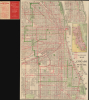

Blanchard's map of Chicago with new street names, steam railroads, street car lines, street numbers and sections.
Reconsidering Chicago's streets.
- Digital Map Information
- Suitable for large format printing
- Full resolution TIFF file
- ICC color profile embedded
- Delivered instantly via download link
Reconsidering Chicago's streets.
This is a large 1909 folding map of Chicago issued under the Rufus Blanchard imprint, with a supplementary diagram copyrighted by George F. Cram. Published as Chicago introduced its modern house-numbering system, it captures a metropolis working to bring order to decades of rapid expansion. An extensive network of railroads, elevated trains, and streetcar lines links the city's neighborhoods, passenger terminals, industrial districts, and the Union Stock Yards.A Closer Look
The map details streets, transportation routes, major public institutions, and parks, with two insets extending coverage along the Lake Michigan shoreline north and south of the main map. Distinctive jagged lines identify the elevated railways, or 'L.' In contrast, dashed lines trace streetcar routes, revealing the interconnected transit network that sustained the growing city.Chicago's role as a national railroad hub is especially prominent. Tracks converge on freight depots, the Union Stock Yards, and passenger terminals labeled Grand Central Depot, Dearborn Station, Rock Island Depot, Illinois Central Depot, Union Depot, and Nickel Plate Depot. Much of this railway landscape subsequently disappeared or was rebuilt. Grand Central and Central stations were demolished in the 1970s, followed by the old LaSalle Street Station in 1981. Dearborn Station retained its main building but lost its train shed and tracks, while the Union Depot depicted here preceded the present Union Station, opened in 1925.
Chicago's New Address System
The title's reference to 'new street names' accompanies a particularly timely feature: a diagram explaining Chicago's new house-numbering system. Rapid growth and successive annexations had left the city with inconsistent addresses, duplicate street names, and roads that changed names along their course. The reforms sought to make this sprawling urban geography easier to navigate.Adopted by ordinance on June 22, 1908, the new numbering system took effect across most of Chicago on September 1, 1909. State Street became the baseline for east-west addresses, and Madison Street the baseline for north-south addresses. Numbers generally increased by 800 per mile, or 100 per eighth-mile block, with established exceptions on the South Side. The diagram above the title illustrates the relationship between house numbers and the city's mile and half-mile streets.
The downtown district was initially exempted and adopted the system on April 1, 1911. The map thus documents the introduction of an addressing framework that continues to organize Chicago today.
Publication History and Census
This map was published in 1909 by the firm of Rufus Blanchard, who had died five years earlier, while the copyright of George F. Cram appears in the inset map above the title. The present example is undated, but we previously sold a comparable dated example from 1909. It is possible that this example was issued shortly after, in 1910 or 1911. It should not be confused with the similar 1909 'Blanchard's map of Chicago and suburbs: showing wards, congressional and senatorial districts,' which also lists George F. Cram as the publisher. Cram was Blanchard's nephew, and the two co-owned a map publishing house that the 1871 Great Chicago Fire destroyed. Afterward, Cram started his own publishing house, but a residual relationship between the two appears to have continued. Blanchard regularly published maps with this title or similar titles in the late 19th and early 20th century, all of which are scarce today. The present map is only listed in the OCLC among the holdings of the Chicago Public Library.Cartographers
Rufus Blanchard Evanston (March 7, 1821 - January 3, 1904) was an American photographer, mapmaker, publisher, viewmaker, bookseller, and publisher active in Chicago in the second half of the 19th century. Blanchard was born in Lyndeborough, New Hampshire. He studied at Ipswich Academy, where he showed proficiency in Latin and Mathematics. He moved to New York in 1835 to live with his brother, Calvin Blanchard, who ran a bookstore at 78 Nassau St. He witnessed both the New York Fire of 1835 and the Wall Street bank panic of 1836. Perhaps believing civilization was doomed, he moved to the backwoods of Ohio, where he spent three years bushwhacking, hunting, and trapping. Returning to New York in 1840, Blanchard worked for the Harper Brothers publishing house. The publishing business suited Blanchard, leading to his relocation to Lowell, Massachusetts in 1843 to open a bookshop. This business lasted just 3 years before the restless young man moved again, this time to Cincinnati, where he opened another shop with his brother Edwin Blanchard. After some success, he established an annex office in New Orleans. The Cholera epidemic of 1847-1848, followed by the great fire of St. Louis, unfortunately, devastated his interests in the region. He moved back to New York in 1849, briefly establishing a printing concern with Charles Morse, son of the famous inventor, and working with the J. H. Colton firm. He relocated to Chicago sometime before 1853, when he established himself there as a printer and publisher. He relocated his business to the railroad hub of Chicago (52 LaSalle Street) in 1854 to capitalize on the national need for good railroad maps. In 1857, he published Chicago's first street guide. In addition to his Chicago business, he also had an office in Wheaton, Illinois. His nephew, George Cram (1842 - 1928), joined his business in 1867, after being discharged from the Union Army, and they rebranded as 'Blanchard and Cram.' Both 'Blanchard and Cram' of Chicago and the Wheaton businesses were destroyed in 1871 - the main business by the Great Chicago Fire, and the Wheaton office in a smaller fire. Nonetheless, Blanchard persevered and rebuilt both enterprises, though without Cram, who established his own firm, the George F. Cram and Company. In 1885, fire again destroyed his business, and he lost much of his map stock, but he persevered and rebuilt. Blanchard's personal life mirrored the highs and lows of his business life. He first married Permilla Far (1829 - 1857) in 1856. On their honeymoon, Permilla was severely injured and died shortly thereafter, in 1857, from related complications. He remarried in 1858 to Anna E. Hall (1842 - 1925). Blanchard lived to 83, and during the entire time, continued to actively photograph, write, and publish. It is said that he 'never grew old in heart or brain.' Further Details...
George Franklin Cram (May 20, 1842 - 1928) was an American map publisher active in the late 19th and early 20th centuries. During the American Civil War, Cram served as a staff cartographer for the Union General Ulysses S. Grant and participated in Sherman's 'March to the Sea'. In 1867, after being discharged from the army, George Cram moved to Chicago, where he founded 'Blanchard and Cram' with his uncle Rufus Blanchard Evanston. Blanchard and Cram was a supply house for the book trade - though they also published a few maps during this period. This short lived business was destroyed in the 1871 by the Great Chicago Fire. After the fire, recognizing a business opportunity in the burgeoning railroad industry, Cram reinvented himself as cartographic publisher, opening the Cram Map Depot. Like fellow Chicago publisher Rand McNally, Cram took advantage of the economical wax engraving processes to inexpensively produce maps in vast quantities. His signature publication, the Unrivaled Atlas of the World became the world's best-selling atlas and was published from the 1880s to 1952. On retiring in 1921, Cram sold his company to Edward A. Peterson of the National Map Company (Scarborough Company). Peterson moved the company to Indianapolis where, following Cram's death, he rebranded the National Map Company as the George F. Cram Company, surely thinking to capitalize on the established identity of the firm. In 1930 he entered the globe market for which the firm was best known from the mid-20th century. In time the firm expanded globally passing becoming a major concern. Loren B. Douthit became company president in 1968 and the Douthit family ran the business until Herff Jones, Inc., bought the company in 2005. Further Details...
Condition
Very good. Archival tissue verso reinforcments at most fold intersection points - for stability, not necessary to repair any damage. Othewise excellent.
References
Rumsey 4464.000, OCLC 865507164.