This item has been sold, but you can get on the Waitlist to be notified if another example becomes available, or purchase a digital scan.
1905 Chicago and Eastern Illinois Railroad Map of the Central United States
ChicagoEasternIllinois-poolebros-1905$62.50

Title
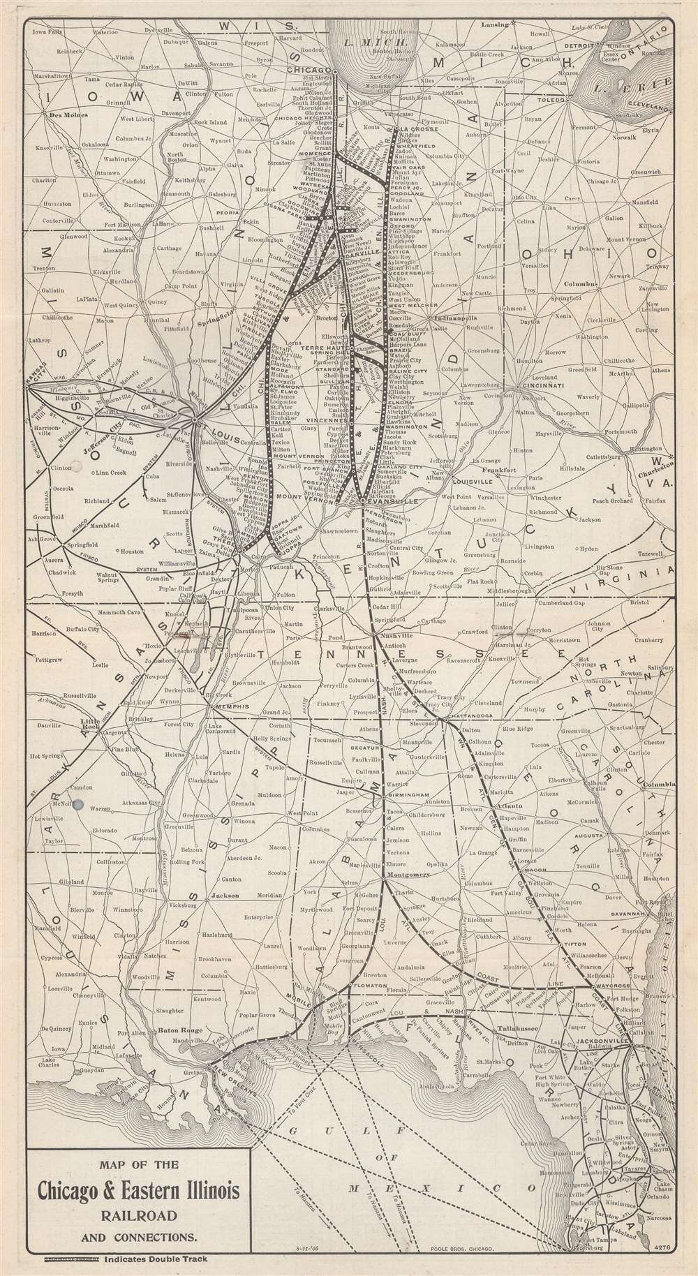
Map of the Chicago and Eastern Illinois Railroad and Connections.
1905 (undated) 15.75 x 8.5 in (40.005 x 21.59 cm) 1 : 4350000
1905 (undated) 15.75 x 8.5 in (40.005 x 21.59 cm) 1 : 4350000
Description
This is a 1901 Poole Brothers and Chicago and Eastern Railroad map of the central United States. Focused on the Chicago and Eastern Railroad's network in Illinois and Indiana, the map depicts from Lake Michigan south to Tampa, Florida and from Kansas City, Missouri to Cleveland, Ohio, and Charleston, West Virginia. Thick black lines highlight the Chicago and Eastern's rail lines and every stop along their routes. As would be expected from a railroad map, connecting railroads are illustrated as well.
The Chicago and Eastern Illinois Railroad
The Chicago and Eastern Illinois Railroad connected Chicago with southern Illinois, Evansville, and St. Louis. Founded in 1877, the Chicago and Eastern Illinois was created by consolidating three railroads: the 'Chicago, Danville and Vincennes Railroad', the 'Evansville, Terre Haute and Chicago Railroad', and the 'Evansville and Terre Haute Railroad'. The Chicago and Eastern Illinois then built an extension to the Mississippi River at Thebes, Illinois. The railroad continued to grow throughout the central United States until 1933, when it entered bankruptcy. It emerged from bankruptcy in 1940, just before World War II, and began a second expansion phase, reaching St. Louis in 1954. In 1961, the Missouri Pacific Railroad began quietly purchasing Chicago and Eastern Illinois stock and assumed full control of the railroad in 1967. The Chicago and Eastern Railroad was a separate subsidiary of the Missouri Pacific until 1976, when the Missouri Pacific merged the Chicago and Eastern into their network.Publication History and Census
This map was created by Poole Brothers and published by the Chicago and Eastern Illinois Railroad in 1905. This is the only known surviving example.Cartographer
Poole Brothers (1878 - 1968) were a Chicago based firm active in the late 19th and early 20th century with an initial focus on promotional railroad maps. Poole Brothers was founded by George Amos Poole (March 20, 1843 – September 7, 1918). In 1868, Poole, along with his uncle William H. Rand (1828 - 1915) and Andrew McNally (1836 - 1904), purchased the Chicago Tribune's job printing plant and formed the firm Rand McNally. In 1878, he left Rand McNally to form, with his brother William H. Poole, Poole Brothers, a direct competitor to Rand McNally for the lucrative railroad business. Like many of its competitors, Poole Brothers maintained an office on Chicago's Printer's Row (downtown Loop district). Their earliest known work is an 1880 map of Yellowstone National Park. In 1887, Poole Brothers, Andrew McNally, and several others formed the United Typothetae of America, a master printers association. In 1848, they were cited, along with Rand McNally and George Cram, by the Federal Trade Commission for price fixing. Their earliest known work is an 1880 map of Yellowstone National Park. Afterward they went on to produce a vast range of maps and other print products including tickets, cards, coupons, and restaurant menus. In time Poole Brothers merged with Newman-Randolph, which was then acquired by the American Can Company in the early 1960s. The American Can Company liquidated its printing concerns later in the same decade. More by this mapmaker...
Condition
Very good. Bound into Chicago and Eastern Illinois time table booklet dated October 1905.