This item has been sold, but you can get on the Waitlist to be notified if another example becomes available, or purchase a digital scan.
1788 Molina map of Chile and Argentina
Chile-molina-1788$1,250.00

Title
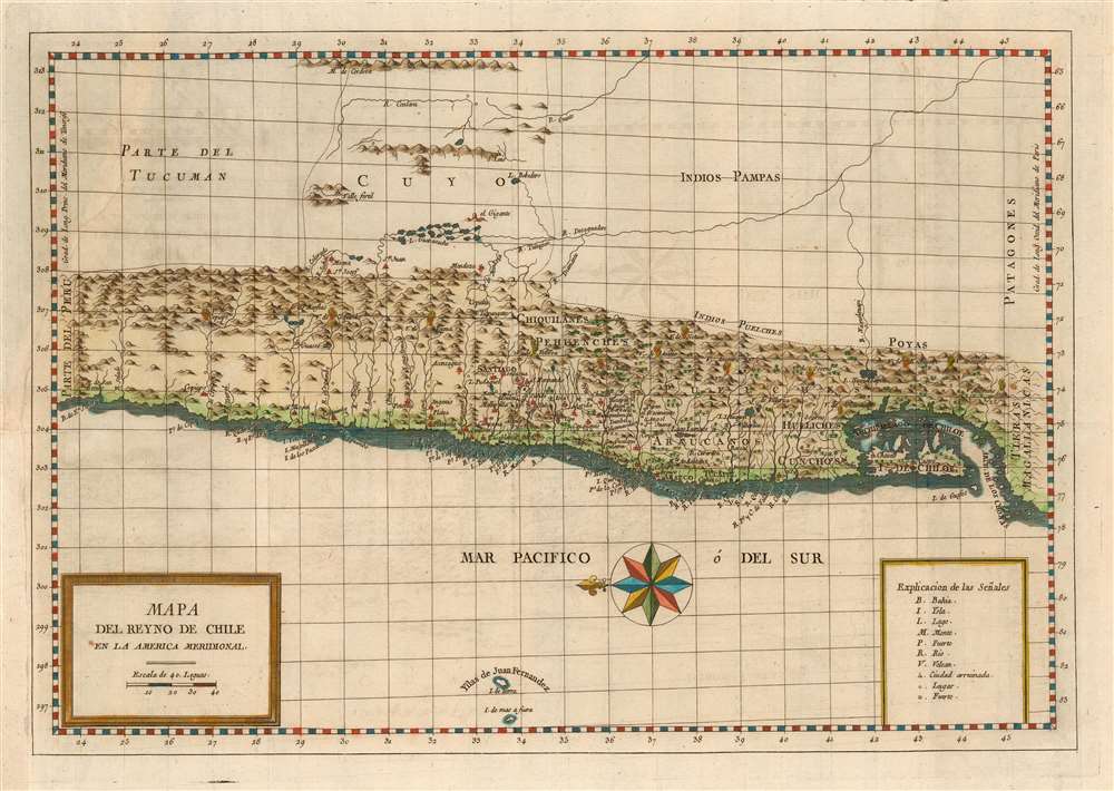
Mapa Del Reyno De Chile En La America Meridional.
1788 (undated) 11.25 x 16.25 in (28.575 x 41.275 cm) 1 : 6172833
1788 (undated) 11.25 x 16.25 in (28.575 x 41.275 cm) 1 : 6172833
Description
This is a 1788 map of the Kingdom of Chile, produced for inclusion in Juan Ignacio Molina's Compendio de la Historia Geográfica, Natural y Civil del Reino de Chile. The map is among the few maps of the region based on information from someone who actually lived there; Molina's experience as a naturalist and ornithologist brought him far afield, and the map reflects a deeper knowledge of areas away from the coastline than do previous maps. The east-oriented map extends from Peru to south of Chiloe island. The abundant settlement of the coastal strip and its rivers are clearly defined. Chile's mountainous terrain is depicted pictorially, and thirteen active volcanoes are marked on the map.
The Cuyo Region
Molina's travels appear to have brought him to the Cuyo region, which is shown in higher detail than on any earlier map we have seen. It is bounded by mountains to the east and west - the the Sierras Grandes and the Andes respectively - with the Valle Fertilities shown at its northern extent. Within the region can be seen a complexity of interlocking lakes, the Lagunas de Guanacache; this was an exohreic system of marshes fed by the Mendoza and San Juan rivers and discharging into Desagüadero river. Originally there were a total of 25 interconnected lagoons with abundant islands, surrounded by fertile land. Beginning in the late 19th century overexploitation of the waters of the Desaguadero, Mendoza and San Juan rivers has led to the region drying up, with the lagoons appearing only in seasons of great thaws.El Gigante?
A mountain, seemingly orphaned from any attendant range, appears at the southeastern reach of the Lagunas; it would seem to correspond with the geological formations of the Sierra de las QuijadasPublication History and Census
This map appears to be rare. We do not see it in dealers' catalogues or auction records. OCLC lists the separate map only in the Biblioteca Nacional de Espana, and there Ibero-Amerikanisches Institut. Molina's Compendio de la Historia Geográfica, Natural y Civil del Reino de Chile is well represented in institutional collections.CartographerS
Juan Ignacio Molina (June 24, 1740 - September 12, 1829) was a Spanish/ Chilean Jesuit priest, naturalist, historian, botanist, ornithologist and geographer. He was born in Guaraculén in the current province of Linares, in the Maule Region of Chile. He was educated at Talca and the Jesuit College at Concepción. In 1768 he (like the rest of his order) was expelled from the Spanish Empire, forcing him to leave Chile. He settled in Bologna, Italy, where he would become professor of natural sciences. There he wrote Saggio sulla Storia Naturale del Chili , the first account of the natural history of that country. As early as 1787 Molina theorized that South America had been populated from south Asia through the "infinite island chains" of the Pacific while North America could have been populated from Siberia. A number of genuses of plant are named after him, as is a species of Chilean lizard. More by this mapmaker...
Antonio de Sancha (1720—1790) was a Spanish printer active in Madrid. He worked for the printer-bookseller Sanz before opening his own bookshop and, in 1771, a printing office. Learn More...
Source
Molina, J. I. Compendio de la historia geografica, natural y civil del reyno de Chile (Sancha, Madrid) 1788.
Condition
Good condition. Surface mend with virtually no loss. Fine hand color.
References
OCLC 8371160587.